THIS AVALANCHE FORECAST EXPIRED ON March 4, 2020 @ 6:59 am
Avalanche Forecast published on March 3, 2020 @ 6:59 am
Issued by Andy Anderson - Tahoe National Forest - Sierra Avalanche Center

Increased warming today means that loose wet avalanches will become likely on sunny slopes as the day warms up. Some fragile slabs of wind drifted snow may also still linger at on leeward aspects. CONSIDERABLE avalanche danger exists at all elevations. 

3. Considerable

?

Above Treeline
Dangerous avalanche conditions. Careful snowpack evaluation, cautious route-finding and conservative decision-making essential.

3. Considerable

?

Near Treeline
Dangerous avalanche conditions. Careful snowpack evaluation, cautious route-finding and conservative decision-making essential.

3. Considerable

?

Below Treeline
Dangerous avalanche conditions. Careful snowpack evaluation, cautious route-finding and conservative decision-making essential.
    Dangerous avalanche conditions. Careful snowpack evaluation, cautious route-finding and conservative decision-making essential.
Avalanche Problem 1: Loose Wet
  • Type ?
  • Aspect/Elevation ?
  • Likelihood ?
    Certain
    Very Likely
    Likely
    Possible
    Unlikely
  • Size ?
    Historic
    Very Large
    Large
    Small

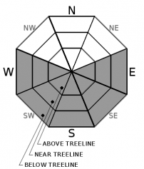
Today's forecast calls for decreased ENE winds and increased daytime temperatures. These warm temperatures combined with the strong March sunshine may cause enough rapid warming for loose wet avalanches to become more widespread later today on sunny E-SE-S-SW-W aspects. As the day warms, human triggered loose wet avalanches should become likely and some natural loose wet avalanches may be possible. These could entrain all of the new snow and would slide on the old crusts. They could have serious consequences especially on long, steep, sunny slopes where they could run farther and entrain more snow.

Traveling before the snowpack warms up or on colder northerly facing aspects could lead to finding colder softer snow and avoiding potential loose wet problems. As soon the snowpack starts to show signs of warming like roller balls or pinwheels, dripping trees, or wet sticky surface snow, it is time to move to lower angle slopes, colder aspects, or head to the lake for a picnic.

Avalanche Problem 2: Wind Slab
  • Type ?
  • Aspect/Elevation ?
  • Likelihood ?
    Certain
    Very Likely
    Likely
    Possible
    Unlikely
  • Size ?
    Historic
    Very Large
    Large
    Small

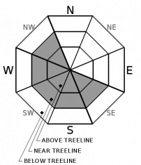
The slabs of wind drifted snow that exist on SE-S-SW-W-NW aspects should become more difficult to trigger as the ENE winds decrease and wind-loaded slows down. Still, it may be possible for a person to trigger a wind slab avalanche today especially on wind-loaded sun-exposed slopes or in cross-loaded gullies. These wind slabs could measure a few feet in depth and could involve enough snow to bury or injure a person.

Identify where wind slabs may exist by using clues like cornices above a slope, drifted snow, and other wind created textures. These areas have the best chances for finding variable wind affected snow and unstable wind slabs. Lower angle more sheltered terrain will hold more consistent and enjoyable snow. 

recent observations

* On Relay Peak yesterday, skier-triggered shooting cracks and whumpfing occurred on a cross-loaded SE facing gully. 

* Yesterday, observers noted continued strong ENE winds on Relay Peak and Flagpole Peak. Less wind existed on Silver Peak. In all three areas, new snow still remained available for transport and a mix of scoured surfaces and wind-affected surfaces existed on exposed slopes.

* A ski kick on a steep N facing below treeline slope on Silver Peak triggered a small loose dry sluff yesterday morning. 

* By yesterday afternoon observers noted some signs of warming including sticky wet snow on sunny SE-S aspects on Silver Peak and some small roller-balls on S aspects of Relay Peak.  

Weather and CURRENT CONDITIONS
weather summary

Yesterday's strong ENE winds and cooler temperatures should give way to light E winds and warmer temperatures today. Some sensors already showed temperatures near yesterday's highs (upper 20's and low 30's) as of 6 am this morning. Expect daytime highs in the mid to upper 40's today and upper 40's to mid 50's tomorrow above 7000 ft. The forecast calls for continued sun and warming through Thursday with temperatures climbing well above average.

CONDITIONS ALONG THE SIERRA CREST BETWEEN 8200 FT. AND 9200 FT. IN THE LAST 24 HOURS
6am temperature: 24 to 31 deg. F.
Max. temperature: 28 to 32 deg. F.
Average ridgetop wind direction: ENE
Average ridgetop wind speed: 40 to 60 mph
Maximum ridgetop wind gust: 138 mph
New snowfall: 0 inches
Total snow depth: 42 to 53 inches
Two-Day Mountain Weather Forecast Produced in partnership with the Reno NWS
For 7000 ft. to 8000 ft.
Tuesday Tuesday Night Wednesday
Weather: Sunny. Chance of precipitation is 0%. Clear. Chance of precipitation is 0%. Sunny. Chance of precipitation is 0%.
Temperatures: 43 to 49 deg. F. 26 to 32 deg. F. 50 to 56 deg. F.
Mid Slope Winds: Light winds. Light winds. Light winds.
Expected snowfall: No accumulation. | SWE = none. No accumulation. | SWE = none. No accumulation. | SWE = none.
For 8000 ft. to 9000 ft.
Tuesday Tuesday Night Wednesday
Weather: Sunny. Chance of precipitation is 0%. Clear. Chance of precipitation is 0%. Sunny. Chance of precipitation is 0%.
Temperatures: 38 to 44 deg. F. 24 to 29 deg. F. 45 to 51 deg. F.
Ridge Top Winds: East around 15 mph in the morning becoming light. North around 10 mph. West around 10 mph.
Expected snowfall: No accumulation. | SWE = none. No accumulation. | SWE = none. No accumulation. | SWE = none.
Disclaimer

This avalanche forecast is provided through a partnership between the Tahoe National Forest and the Sierra Avalanche Center. This forecast covers the Central Sierra Nevada Mountains between Yuba Pass on the north and Ebbetts Pass on the south. Click here for a map of the forecast area. This forecast applies only to backcountry areas outside established ski area boundaries. This forecast describes general avalanche conditions and local variations always occur. This forecast expires 24 hours after the posted time unless otherwise noted. The information in this forecast is provided by the USDA Forest Service who is solely responsible for its content.

For a recorded version of the avalanche forecast call (530) 587-3558 x258