THIS AVALANCHE FORECAST EXPIRED ON March 31, 2020 @ 6:59 am
Avalanche Forecast published on March 30, 2020 @ 6:59 am
Issued by Andy Anderson - Tahoe National Forest - Sierra Avalanche Center

Recent snow and wind have built fresh slabs of wind drifted snow and large fragile cornices on and above slopes in near and above treeline terrain. Human triggered wind slab avalanches will be possible today. Slab avalanches breaking on a weak layer of buried surface hoar have become unlikely, but they may not be impossible on some isolated terrain feature. MODERATE avalanche danger exists at all elevations. 

2. Moderate

?

Above Treeline
Heightened avalanche conditions on specific terrain features. Evaluate snow and terrain carefully; identify features of concern.

2. Moderate

?

Near Treeline
Heightened avalanche conditions on specific terrain features. Evaluate snow and terrain carefully; identify features of concern.

2. Moderate

?

Below Treeline
Heightened avalanche conditions on specific terrain features. Evaluate snow and terrain carefully; identify features of concern.
    Heightened avalanche conditions on specific terrain features. Evaluate snow and terrain carefully; identify features of concern.
Avalanche Problem 1: Wind Slab
  • Type ?
  • Aspect/Elevation ?
  • Likelihood ?
    Certain
    Very Likely
    Likely
    Possible
    Unlikely
  • Size ?
    Historic
    Very Large
    Large
    Small

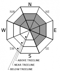
Slabs of wind drifted snow and large fragile cornices exist on wind-loaded and cross-loaded NW-N-NE-E-SE aspects. Yesterday skiers triggered small wind slabs on NE and SE facing slopes. Similar human triggered wind slab avalanches remain possible. Strong winds could also add additional snow to these wind slabs today. These fresh wind slabs should remain small in most places but some of them could entrain enough snow to bury or injure a person. It is not impossible that a wind slab avalanche or large cornice failure could provide a large enough trigger to break the buried persistent weak layer mentioned below.

Identify where wind slabs may exist using clues like cornices above a slope, drifted snow, wind-scoured ridges, and other wind created surface textures. Travel plans that give wind-loaded slopes and the cornices above them a wide berth will help avoid unexpected wind slab avalanches or cornice failures. Plenty of great snow exists on more sheltered terrain. 

Avalanche Problem 2: Persistent Slab
  • Type ?
  • Aspect/Elevation ?
  • Likelihood ?
    Certain
    Very Likely
    Likely
    Possible
    Unlikely
  • Size ?
    Historic
    Very Large
    Large
    Small

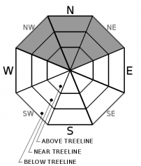
No new persistent slab avalanches have been reported since Friday. Additionally, snowpit data targeting the persistent weak layer (surface hoar on top of a thin crust) shows a strengthening trend in the snowpack. Triggering a persistent slab avalanche has become unlikely on a regional scale. Unlikely does not mean impossible and some isolated terrain feature on a NW-N-NE aspect may still hold a pocket of unstable snow. In the unlikely event, someone does trigger one of these avalanches they could still break 1 to 3 ft deep and propagate around terrain features.

Some uncertainty still surrounds this unusual problem. Continue to pay attention to where an isolated persistent slab might exist especially in terrain with the potential for larger triggers like cornice failures or wind slab failures. Digging into the snow and testing this layer can help provide information about the location and state of the weak layer. If you have any lingering doubts about the potential for a persistent slab avalanche, go ahead choose a different aspect or more conservative terrain.

recent observations

Yesterday ski cuts triggered wind slabs between 4 and 12 inches deep on test slopes on Wildflower Ridge and on larger slopes on the north side of Castle Peak. Skiers also accidentally triggered a small wind slab on a SE facing slope near Grouse Rocks.

Snowpits near avalanche activity that occurred on 3/27 on Mt. Judah found the buried surface hoar layer, but tests targetting this layer no longer showed signs of instability. Observations in other locations did not report any new persistent slab avalanche activity or other signs of ongoing instability like whumpfing or unstable test results yesterday. 

 By midday, observers reported warm and sticky snow on top of old melt-freeze crusts on E, SE, and S aspects. Skiers started to trigger small roller balls on E aspects on Mt. Judah by 11:00 am. 

Weather and CURRENT CONDITIONS
weather summary

Low pressure moving through the Pacific NW should bring strong SW winds to the area today and tomorrow. This system should also allow for continued cloud cover over the region through today. Daytime highs should climb a few degrees above yesterday. The forecast calls for more sun and warmer temperatures tomorrow. 

CONDITIONS ALONG THE SIERRA CREST BETWEEN 8200 FT. AND 9200 FT. IN THE LAST 24 HOURS
6am temperature: 19 to 26 deg. F.
Max. temperature: 30 to 35 deg. F.
Average ridgetop wind direction: SW
Average ridgetop wind speed: 20 to 35 mph
Maximum ridgetop wind gust: 67 mph
New snowfall: 1 to 2 inches
Total snow depth: 61 to 82 inches
Two-Day Mountain Weather Forecast Produced in partnership with the Reno NWS
For 7000 ft. to 8000 ft.
Monday Monday Night Tuesday
Weather: Partly to mostly cloudy. Slight chance of snow in the afternoon. Snow levels below 7000 feet. Chance of precipitation is 15%. Partly cloudy. Slight chance of snow. Snow levels below 7000 feet. Chance of precipitation is 15%. Partly cloudy then becoming sunny. Snow levels 7000 feet. Chance of precipitation is 5%.
Temperatures: 38 to 44 deg. F. 25 to 30 deg. F. 42 to 48 deg. F.
Mid Slope Winds: Southwest around 15 mph with gusts to 35 mph. Southwest around 15 mph with gusts to 35 mph. Southwest 15 to 20 mph with gusts to 35 mph.
Expected snowfall: Up to 1 inch. | SWE = trace amounts. Up to 1 inch. | SWE = less than 0.10 inch. No accumulation. | SWE = none.
For 8000 ft. to 9000 ft.
Monday Monday Night Tuesday
Weather: Partly to mostly cloudy. Slight chance of snow in the afternoon. Snow levels below 7000 feet. Chance of precipitation is 15%. Partly cloudy. Slight chance of snow in the evening. Snow levels below 7000 feet. Chance of precipitation is 10%. Partly cloudy then becoming sunny. Snow levels 7000 feet. Chance of precipitation is 5%.
Temperatures: 33 to 39 deg. F. 23 to 28 deg. F. 37 to 43 deg. F.
Ridge Top Winds: Southwest 20 to 30 mph with gusts to 55 mph. Southwest 20 to 35 mph with gusts to 70 mph. Southwest 25 to 40 mph with gusts to 70 mph.
Expected snowfall: Up to 1 inch. | SWE = trace amounts. Up to 1 inch. | SWE = less than 0.10 inch. No accumulation. | SWE = none.
Disclaimer

This avalanche forecast is provided through a partnership between the Tahoe National Forest and the Sierra Avalanche Center. This forecast covers the Central Sierra Nevada Mountains between Yuba Pass on the north and Ebbetts Pass on the south. Click here for a map of the forecast area. This forecast applies only to backcountry areas outside established ski area boundaries. This forecast describes general avalanche conditions and local variations always occur. This forecast expires 24 hours after the posted time unless otherwise noted. The information in this forecast is provided by the USDA Forest Service who is solely responsible for its content.

For a recorded version of the avalanche forecast call (530) 587-3558 x258