THIS AVALANCHE FORECAST EXPIRED ON March 5, 2020 @ 6:48 am
Avalanche Forecast published on March 4, 2020 @ 6:48 am
Issued by Steve Reynaud - Tahoe National Forest

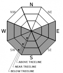
Loose wet avalanche activity will become possible at all elevations as daytime warming occurs today.  MODERATE avalanche danger will exist.

2. Moderate

?

Above Treeline
Heightened avalanche conditions on specific terrain features. Evaluate snow and terrain carefully; identify features of concern.

2. Moderate

?

Near Treeline
Heightened avalanche conditions on specific terrain features. Evaluate snow and terrain carefully; identify features of concern.

2. Moderate

?

Below Treeline
Heightened avalanche conditions on specific terrain features. Evaluate snow and terrain carefully; identify features of concern.
    Heightened avalanche conditions on specific terrain features. Evaluate snow and terrain carefully; identify features of concern.
Avalanche Problem 1: Loose Wet
  • Type ?
  • Aspect/Elevation ?
  • Likelihood ?
    Certain
    Very Likely
    Likely
    Possible
    Unlikely
  • Size ?
    Historic
    Very Large
    Large
    Small

Loose wet avalanches will become possible as daytime warming occurs today.  Well above average temperatures with light winds will lead to rapid warming in the late morning hours.  Overnight temperature inversions have made for above freezing temperatures at most locations above 7500-8000'.  Loose wet avalanches could involve all the recent storm snow sliding on the previous surface crusts.

Early to mid-morning will be the best time to travel on sunny aspects.  As the snow surface warms and gets heavier, deteriorating conditions will exist with increasing likelihood of loose wet avalanches.  Once the snow becomes wet and punchy, or roller balls and pinwheels start to occur, it will be time to change aspects or call it a day.  Small loose wet avalanches could have increased consequences with our low snowpack conditions with many rocks and obstacles present.

recent observations

Warm and variable conditions were reported yesterday from Rubicon Peak (West Shore area), Mt. Tallac (Desolation Wilderness area), and Castle Peak (Donner Summit area).  Wet and sticky snow was seen on all aspects by late morning with some areas of previous wind-blown snow in exposed areas.  Minor roller balls were reported with light NE winds helping to keep the snow surface somewhat cool at the higher elevations.


Weather and CURRENT CONDITIONS
weather summary

Well above average temperatures and dry conditions will continue for the next few days.  Overnight inversions have many locations reporting above freezing temperatures above 7500-8000' with colder air settling into the lower valleys.  High temperatures are expected to increase up to 10 degrees warmer than yesterday, with highs in the mid 40's to mid 50's in the mountains with generally light winds.  Clouds and wind will increase on Friday as a small storm approaches our area for Saturday with the potential of light snow.   

CONDITIONS ALONG THE SIERRA CREST BETWEEN 8200 FT. AND 9200 FT. IN THE LAST 24 HOURS
6am temperature: 31 to 40 deg. F.
Max. temperature: 40 to 51 deg. F.
Average ridgetop wind direction: NE shifting to SW
Average ridgetop wind speed: 20 to 40mph becoming 5 to 10 mph
Maximum ridgetop wind gust: 75 mph
New snowfall: 0 inches
Total snow depth: 39 to 50 inches
Two-Day Mountain Weather Forecast Produced in partnership with the Reno NWS
For 7000 ft. to 8000 ft.
Wednesday Wednesday Night Thursday
Weather: Sunny. Snow levels below 7000 feet increasing to 7500 feet in the afternoon. Chance of precipitation is 0%. Clear. Snow levels 8500 feet decreasing to 7500 feet after midnight. Chance of precipitation is 0%. Sunny then becoming partly cloudy. Snow levels below 7000 feet increasing to 7500 feet in the afternoon. Chance of precipitation is 0%.
Temperatures: 50 to 56. deg. F. 28 to 34. deg. F. 51 to 57. deg. F.
Mid Slope Winds: Light winds. Light winds becoming southwest around 15 mph with gusts to 35 mph after midnight. Light winds becoming southwest around 15 mph with gusts to 35 mph in the afternoon.
Expected snowfall: No accumulation. | SWE = none. No accumulation. | SWE = none. No accumulation. | SWE = none.
For 8000 ft. to 9000 ft.
Wednesday Wednesday Night Thursday
Weather: Sunny. Snow levels below 7000 feet increasing to 7500 feet in the afternoon. Chance of precipitation is 0%. Clear. Snow levels 8500 feet decreasing to 7500 feet after midnight. Chance of precipitation is 0%. Sunny then becoming partly cloudy. Snow levels below 7000 feet increasing to 7500 feet in the afternoon. Chance of precipitation is 0%.
Temperatures: 45 to 51. deg. F. 28 to 34. deg. F. 44 to 50. deg. F.
Ridge Top Winds: Light winds. Light winds becoming southwest around 15 mph with gusts to 30 mph after midnight. Southwest 15 to 30 mph with gusts to 50 mph.
Expected snowfall: No accumulation. | SWE = none. No accumulation. | SWE = none. No accumulation. | SWE = none.
Disclaimer

This avalanche forecast is provided through a partnership between the Tahoe National Forest and the Sierra Avalanche Center. This forecast covers the Central Sierra Nevada Mountains between Yuba Pass on the north and Ebbetts Pass on the south. Click here for a map of the forecast area. This forecast applies only to backcountry areas outside established ski area boundaries. This forecast describes general avalanche conditions and local variations always occur. This forecast expires 24 hours after the posted time unless otherwise noted. The information in this forecast is provided by the USDA Forest Service who is solely responsible for its content.

For a recorded version of the avalanche forecast call (530) 587-3558 x258