THIS AVALANCHE FORECAST EXPIRED ON March 6, 2020 @ 6:47 am
Avalanche Forecast published on March 5, 2020 @ 6:47 am
Issued by Steve Reynaud - Tahoe National Forest

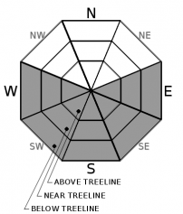
Loose wet avalanches will become possible at all elevations today.  Avalanche danger will rise to MODERATE as daytime warming occurs.

2. Moderate

?

Above Treeline
Heightened avalanche conditions on specific terrain features. Evaluate snow and terrain carefully; identify features of concern.

2. Moderate

?

Near Treeline
Heightened avalanche conditions on specific terrain features. Evaluate snow and terrain carefully; identify features of concern.

2. Moderate

?

Below Treeline
Heightened avalanche conditions on specific terrain features. Evaluate snow and terrain carefully; identify features of concern.
    Heightened avalanche conditions on specific terrain features. Evaluate snow and terrain carefully; identify features of concern.
Avalanche Problem 1: Loose Wet
  • Type ?
  • Aspect/Elevation ?
  • Likelihood ?
    Certain
    Very Likely
    Likely
    Possible
    Unlikely
  • Size ?
    Historic
    Very Large
    Large
    Small

Loose wet avalanches will be possible today as daytime warming occurs.  Another warm day is forecasted with above freezing overnight temperatures at the upper elevations due to temperature inversions.  Sunny terrain will warm quickly this morning and become wet by late morning.  Slopes with recent storm snow will be the most likely areas to produce loose wet instabilities today.

Early to mid-morning will continue to be the best time for travel on sunny slopes.  Small roller balls and pinwheels will be indicators that the snow is wet and losing strength.  Snow conditions will deteriorate along with increasing chances for loose wet avalanches into the mid-day and afternoon hours.   

recent observations

Observations were made on Incline Lake Peak in the Mt. Rose area yesterday.  Northerly aspects are a mixed bag of wind scoured snow, wet and heavy snow, along with some pockets of unconsolidated snow in wind protected below treeline areas.  Southerly aspects are transitioning back to spring conditions.  Slopes that have been wind scoured back down to firm crusts are transitioning the fastest back to corn snow conditions.


Weather and CURRENT CONDITIONS
weather summary

It will continue warm and dry through Friday ahead of an approaching storm on Saturday.  SW winds will start to increase today and will continue through Friday.  This storm will be on the small side with a couple inches of snow possible in town and up to 4 to 6'' along the Sierra Crest.  Clouds will linger on Sunday and Monday with cooler temperatures.

CONDITIONS ALONG THE SIERRA CREST BETWEEN 8200 FT. AND 9200 FT. IN THE LAST 24 HOURS
6am temperature: 33 to 40 deg. F.
Max. temperature: 46 to 53 deg. F.
Average ridgetop wind direction: NE shifting to SW
Average ridgetop wind speed: 10 to 20 mph
Maximum ridgetop wind gust: 31 mph
New snowfall: 0 inches
Total snow depth: 36 to 48 inches
Two-Day Mountain Weather Forecast Produced in partnership with the Reno NWS
For 7000 ft. to 8000 ft.
Thursday Thursday Night Friday
Weather: Sunny then becoming partly cloudy. Snow levels 7000 feet increasing to 8000 feet in the afternoon. Chance of precipitation is 0%. Partly cloudy. Snow levels 8000 feet. Chance of precipitation is 0%. Partly cloudy. Snow levels 8000 feet. Chance of precipitation is 0%.
Temperatures: 48 to 54. deg. F. 31 to 37. deg. F. 47 to 53. deg. F.
Mid Slope Winds: Southwest around 15 mph with gusts to 30 mph. Southwest around 15 mph. Gusts up to 30 mph increasing to 40 mph after midnight. Southwest 15 to 25 mph. Gusts up to 35 mph increasing to 45 mph in the afternoon.
Expected snowfall: No accumulation. | SWE = none. No accumulation. | SWE = none. No accumulation. | SWE = none.
For 8000 ft. to 9000 ft.
Thursday Thursday Night Friday
Weather: Sunny then becoming partly cloudy. Snow levels 7000 feet increasing to 8500 feet in the afternoon. Chance of precipitation is 0%. Partly cloudy. Snow levels 8000 feet. Chance of precipitation is 0%. Partly cloudy. Snow levels 8000 feet. Chance of precipitation is 0%.
Temperatures: 40 to 48. deg. F. 30 to 35. deg. F. 37 to 43. deg. F.
Ridge Top Winds: Southwest 15 to 30 mph. Gusts up to 50 mph in the afternoon. Southwest 15 to 30 mph with gusts to 60 mph. Southwest 25 to 35 mph with gusts to 75 mph.
Expected snowfall: No accumulation. | SWE = none. No accumulation. | SWE = none. No accumulation. | SWE = none.
Disclaimer

This avalanche forecast is provided through a partnership between the Tahoe National Forest and the Sierra Avalanche Center. This forecast covers the Central Sierra Nevada Mountains between Yuba Pass on the north and Ebbetts Pass on the south. Click here for a map of the forecast area. This forecast applies only to backcountry areas outside established ski area boundaries. This forecast describes general avalanche conditions and local variations always occur. This forecast expires 24 hours after the posted time unless otherwise noted. The information in this forecast is provided by the USDA Forest Service who is solely responsible for its content.

For a recorded version of the avalanche forecast call (530) 587-3558 x258