THIS AVALANCHE FORECAST EXPIRED ON March 8, 2020 @ 7:42 am
Avalanche Forecast published on March 7, 2020 @ 6:42 am
Issued by Brandon Schwartz - Tahoe National Forest

Wind drifted new snow will lead to a wind slab avalanche problem today in above treeline and near treeline areas. MODERATE avalanche danger will exist today above treeline and near treeline. LOW avalanche danger will exist in wind protected areas below treeline. Anticipate that the shallow new snow will hide rocks and logs that have been barely protruding from the existing snowpack.

2. Moderate

?

Above Treeline
Heightened avalanche conditions on specific terrain features. Evaluate snow and terrain carefully; identify features of concern.

2. Moderate

?

Near Treeline
Heightened avalanche conditions on specific terrain features. Evaluate snow and terrain carefully; identify features of concern.

1. Low

?

Below Treeline
Generally safe avalanche conditions. Watch for unstable snow on isolated terrain features.
    Heightened avalanche conditions on specific terrain features. Evaluate snow and terrain carefully; identify features of concern.
Avalanche Problem 1: Wind Slab
  • Type ?
  • Aspect/Elevation ?
  • Likelihood ?
    Certain
    Very Likely
    Likely
    Possible
    Unlikely
  • Size ?
    Historic
    Very Large
    Large
    Small

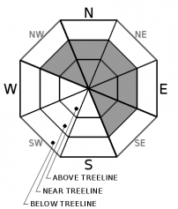
New snow and wind today will create new wind slabs in locations where drifting snow is depositing. This will occur in near and above treeline areas, mainly on NW-N-NE-E-SE aspects. Avalanche size is expected at D1 to D2.

Identify where wind drifted snow is depositing and forming wind slabs. This will occur mainly below cornice areas and/or where pillows of deeper wind drifted snow are forming. Shooting cracks will also be a sign of unstable snow in the immediate area today. Once you have identified the areas of concern for this avalanche problem, make a plan to move around them with caution and minimized risk.

recent observations

* Mist and light rain were reported from Donner Pass (7,100') at 6 am this morning.

* Recent observations from around the forecast area over the past several days have been fairly uniform from one location to another.

* Melt-freeze conditions have been prominent on E-SE-S-SW-W aspects for the latter half of this past week. Surface snow on upper elevation E aspects is still in a transitional state between recent storm snow and consolidated melt-freeze.

* NW-N-NE aspects are a highly variable mix of pockets of lingering recent storm snow, wind scoured areas, and superficial melt-freeze.

* The existing snowpack has a few relative weak layers in the upper snowpack on NW-N-NE aspects but is in good condition to handle the forecast amounts of new snow loading.

Weather and CURRENT CONDITIONS
weather summary

A storm system will move through the forecast area today. Mainly light snowfall is expected with the possibility of short lived periods of higher intensity snowfall. Snowfall from this first storm is expected to end by this evening. Another weather system passing by to the south of the forecast area will bring the possibility of ongoing snow showers through Monday. Ridgetop winds out of the SW became strong overnight. SW winds are expected to decrease gradually tonight and tomorrow. Air temperatures are forecast to remain on the cooler side this week with additional storm systems impacting the region midweek and beyond.

CONDITIONS ALONG THE SIERRA CREST BETWEEN 8200 FT. AND 9200 FT. IN THE LAST 24 HOURS
6am temperature: 24 to 29 deg. F.
Max. temperature: 38 to 46 deg. F.
Average ridgetop wind direction: SW
Average ridgetop wind speed: 43 mph
Maximum ridgetop wind gust: 81 mph
New snowfall: 0 to trace inches
Total snow depth: 36 to 48 inches
Two-Day Mountain Weather Forecast Produced in partnership with the Reno NWS
For 7000 ft. to 8000 ft.
Saturday Saturday Night Sunday
Weather: Mostly cloudy. Chance of snow in the morning, then snow in the afternoon. Snow levels below 7000 feet. Chance of precipitation is 90%. Mostly cloudy. Chance of snow. Snow levels below 7000 feet. Chance of precipitation is 50%. Mostly cloudy. Chance of snow. Snow levels below 7000 feet. Chance of precipitation is 30%.
Temperatures: 31 to 37. deg. F. 21 to 27. deg. F. 33 to 39. deg. F.
Mid Slope Winds: Southwest 15 to 30 mph with gusts to 50 mph. Southwest 10 to 20 mph with gusts to 35 mph in the evening decreasing to up to 10 mph. Light winds.
Expected snowfall: 80% probability of 1 to 3 inches. 20% probability of 3 to 5 inches. | SWE = up to 0.35 inch. Up to 1 inch. | SWE = less than 0.10 inch. No accumulation. | SWE = trace amounts.
For 8000 ft. to 9000 ft.
Saturday Saturday Night Sunday
Weather: Mostly cloudy. Snow. Snow levels below 7000 feet. Chance of precipitation is 100%. Mostly cloudy. Chance of snow. Snow levels below 7000 feet. Chance of precipitation is 55%. Mostly cloudy. Chance of snow. Snow levels below 7000 feet. Chance of precipitation is 35%.
Temperatures: 25 to 31. deg. F. 18 to 23. deg. F. 26 to 34. deg. F.
Ridge Top Winds: Southwest 30 to 50 mph with gusts to 80 mph. Southwest 20 to 35 mph with gusts to 60 mph. South 15 to 25 mph. Gusts up to 40 mph decreasing to 30 mph in the afternoon.
Expected snowfall: 80% probability of 3 to 6 inches. 20% probability of 6 to 10 inches. | SWE = 0.20-0.50 inch. 60% probability of 1 to 3 inches. 40% probability of up to 1 inch. | SWE = up to 0.15 inch. No accumulation. | SWE = trace amounts.
Disclaimer

This avalanche forecast is provided through a partnership between the Tahoe National Forest and the Sierra Avalanche Center. This forecast covers the Central Sierra Nevada Mountains between Yuba Pass on the north and Ebbetts Pass on the south. Click here for a map of the forecast area. This forecast applies only to backcountry areas outside established ski area boundaries. This forecast describes general avalanche conditions and local variations always occur. This forecast expires 24 hours after the posted time unless otherwise noted. The information in this forecast is provided by the USDA Forest Service who is solely responsible for its content.

For a recorded version of the avalanche forecast call (530) 587-3558 x258