THIS AVALANCHE FORECAST EXPIRED ON March 10, 2020 @ 6:53 am
Avalanche Forecast published on March 9, 2020 @ 6:53 am
Issued by Brandon Schwartz - Tahoe National Forest

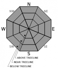
Normal Caution is advised keeping an eye out for unlikely isolated instability where wind drifted snow has deposited just off of ridgetops and sub ridges, especially below cornice features in above treeline and near treeline terrain. LOW avalanche danger is forecast on a regional scale for all elevations.

1. Low

?

Above Treeline
Generally safe avalanche conditions. Watch for unstable snow on isolated terrain features.

1. Low

?

Near Treeline
Generally safe avalanche conditions. Watch for unstable snow on isolated terrain features.

1. Low

?

Below Treeline
Generally safe avalanche conditions. Watch for unstable snow on isolated terrain features.
    Generally safe avalanche conditions. Watch for unstable snow on isolated terrain features.
Avalanche Problem 1: Normal Caution
  • Type ?
  • Aspect/Elevation ?
  • Likelihood ?
    Certain
    Very Likely
    Likely
    Possible
    Unlikely
  • Size ?
    Historic
    Very Large
    Large
    Small

There is plenty of recently wind drifted snow in near treeline and above treeline avalanche start zones along the Sierra Crest to create pause for concern, but we have not seen any signs of or received reports of associated wind slab instability over the past two days. SW winds kicked up a little bit last night with some snow still on the ridgetops and available for some minor additional drifting. Even though the vast majority of slopes are expected to be stable today, don't let this allow for complacency to take hold. Keep isolated instability as a factor in your decision making process when moving around or through slopes just off of ridgetops and sub ridges, especially below cornice features where recently wind drifted snow and potential isolated unstable wind slab could exist.

Cloud cover is expected to be thick enough and widespread enough today to keep loose wet avalanche problems from forming.

recent observations

* Recent new snow amounts of 3 to 5 inches along the Sierra Crest from Saturday with as much as 8 to 10 inches of wind drifted snow deposited into the more efficiently wind loaded avalanche start zones near and above treeline on N-NE-E aspects. The Carson Range on the eastern side of the forecast area received just a trace to 1 inch with little to no drifting.

* Despite the recent load of wind drifted snow, no signs of wind slab instability have been reported in the past two days.

Weather and CURRENT CONDITIONS
weather summary

A weak weather disturbance will move through the region today. This combined with residual moisture in the atmosphere is expected to create cloud cover and isolated snow showers throughout the forecast area today. Ridgetop winds increased a bit last night and are forecast at moderate speed for today. Another weather system passing to the south of the forecast area tomorrow may bring some light snow showers south of Hwy 50. Around 5 degrees of warming is forecast for tomorrow over today. Ridgetop winds are expected to shift from SW to E tomorrow at light to moderate speed.

CONDITIONS ALONG THE SIERRA CREST BETWEEN 8200 FT. AND 9200 FT. IN THE LAST 24 HOURS
6am temperature: 18 to 23 deg. F.
Max. temperature: 26 to 33 deg. F.
Average ridgetop wind direction: SW
Average ridgetop wind speed: 23 mph
Maximum ridgetop wind gust: 42 mph
New snowfall: Trace to 1 inches
Total snow depth: 38 to 51 inches
Two-Day Mountain Weather Forecast Produced in partnership with the Reno NWS
For 7000 ft. to 8000 ft.
Monday Monday Night Tuesday
Weather: Mostly cloudy. Isolated snow showers. Snow levels below 7000 feet. Chance of precipitation is 20%. Mostly cloudy. Snow levels below 7000 feet. Chance of precipitation is 10%. Partly cloudy. Slight chance of snow south of Highway 50. Snow levels below 7000 feet. Chance of precipitation is 20%.
Temperatures: 36 to 42. deg. F. 24 to 29. deg. F. 41 to 47. deg. F.
Mid Slope Winds: South to southwest 10 to 15 mph with gusts to 25 mph. Light winds. Light winds.
Expected snowfall: 20% probability up to 1 inch. 80% probability no accumulation. | SWE = less than 0.10 inch. No accumulation. | SWE = none. Little or no accumulation. | SWE = trace amounts.
For 8000 ft. to 9000 ft.
Monday Monday Night Tuesday
Weather: Mostly cloudy. Isolated snow showers. Snow levels below 7000 feet. Chance of precipitation is 20%. Mostly cloudy. Snow levels below 7000 feet. Chance of precipitation is 10%. Partly cloudy. Slight chance of snow south of Highway 50. Snow levels below 7000 feet. Chance of precipitation is 20%.
Temperatures: 29 to 37. deg. F. 21 to 26. deg. F. 33 to 41. deg. F.
Ridge Top Winds: Southwest 15 to 25 mph with gusts to 45 mph. South around 15 mph with gusts to 30 mph. East 15 to 20 mph with gusts to 30 mph.
Expected snowfall: 20% probability up to 1 inch. 80% probability no accumulation. | SWE = less than 0.10 inch. No accumulation. | SWE = trace amounts. Little or no accumulation. | SWE = trace amounts.
Disclaimer

This avalanche forecast is provided through a partnership between the Tahoe National Forest and the Sierra Avalanche Center. This forecast covers the Central Sierra Nevada Mountains between Yuba Pass on the north and Ebbetts Pass on the south. Click here for a map of the forecast area. This forecast applies only to backcountry areas outside established ski area boundaries. This forecast describes general avalanche conditions and local variations always occur. This forecast expires 24 hours after the posted time unless otherwise noted. The information in this forecast is provided by the USDA Forest Service who is solely responsible for its content.

For a recorded version of the avalanche forecast call (530) 587-3558 x258