THIS AVALANCHE FORECAST EXPIRED ON November 19, 2020 @ 6:59 am
Avalanche Forecast published on November 18, 2020 @ 6:59 am
Issued by Brandon Schwartz - Tahoe National Forest

Everyone is excited for the start of ski, snowboard, snowmobile, avalanche season! Unstable snow and human triggered avalanches are a major concern today. The snowpack is shallow so getting caught in an avalanche will almost certainly involve a collision with rocks and an increased likelihood of injury. Hold back out there today opting for cautious travel and conservative terrain selections.

3. Considerable

?

Above Treeline
Dangerous avalanche conditions. Careful snowpack evaluation, cautious route-finding and conservative decision-making essential.

3. Considerable

?

Near Treeline
Dangerous avalanche conditions. Careful snowpack evaluation, cautious route-finding and conservative decision-making essential.

3. Considerable

?

Below Treeline
Dangerous avalanche conditions. Careful snowpack evaluation, cautious route-finding and conservative decision-making essential.
    Dangerous avalanche conditions. Careful snowpack evaluation, cautious route-finding and conservative decision-making essential.
Avalanche Problem 1: Wind Slab
  • Type ?
  • Aspect/Elevation ?
  • Likelihood ?
    Certain
    Very Likely
    Likely
    Possible
    Unlikely
  • Size ?
    Historic
    Very Large
    Large
    Small

New snow combined with strong to gale force SW winds will have drifted snow in near treeline and above treeline areas. This drifted snow will have deposited deeper and loaded mainly onto NW-N-NE-E-SE aspects. Unstable wind slabs are likely to have formed on slopes where this drifted snow has deposited. Avalanche size up to D2 is expected.

Be wary of any slopes where small cornices or wind pillows have begun to form across the top. Stiffer snow on top of deeper softer snow as felt with the hand, foot, or pole should give pause for concern. Signs of recent avalanches and/or snow surface cracking are clear indications that unstable snow exists.

Avalanche Problem 2: Persistent Slab
  • Type ?
  • Aspect/Elevation ?
  • Likelihood ?
    Certain
    Very Likely
    Likely
    Possible
    Unlikely
  • Size ?
    Historic
    Very Large
    Large
    Small

Weak old snow exists within the pre-storm snowpack and may become overloaded today and create a persistent slab avalanche problem. This type of avalanche problem is scary as it is less predictable. Persistent slab avalanches are often not triggered by the first person on a slope, can be triggered from the bottom of a slope, and can fracture well above, behind, or in front of a person. Basically increased uncertainty and much harder to manage than other avalanche problems. Any whumpfing (audible snowpack collapse), cracking, or signs of avalanches indicate unstable snow in the immediate area. Size D2 avalanches are expected.

The weak layer for this avalanche problem does not exist in all areas. It has been seen on NW-N-NE aspects in below treeline to near treeline terrain above about 8,300' and gets weaker as elevation increases. This is fairly specific so making a plan to avoid it is not that hard. Other aspects or slopes less than 30 degrees in slope angle without steeper slopes above or adjacent are the go to places for avoidance of this avalanche problem. Use your inclinometer to measure slope angles. Guessing slope angles is not a repeatable strategy for success. 

Avalanche Problem 3: Storm Slab
  • Type ?
  • Aspect/Elevation ?
  • Likelihood ?
    Certain
    Very Likely
    Likely
    Possible
    Unlikely
  • Size ?
    Historic
    Very Large
    Large
    Small

On wind protected slopes, instability within the new snow may allow for problematic storm slabs today. This will mainly be in areas near treeline to below treeline where a foot or more of new snow accumulates.

If you encounter signs of instability such as snow surface cracking, recent avalanches, whumpfing, snowpack collapse, and/or unstable snowpit test results seek low angle (sub 30 degree) terrain without steeper slopes above or to the side.

recent observations

The snowpack on the ground was shallow, measuring just 5 to 12 inches on NW-N-NE-E aspects prior to this storm. On SE-S-SW-W aspects, melt created vast areas of bare ground prior to the current snowfall. Over the past two days, snowpack observations have noted a potentially problematic weak layer around mid height in the old snow. This weak snow (facets) exists at the interface between the Nov 7 and Nov 13 snowfall events and can appear as a line in snow about 4 to 8 inches above ground level. The snow is weakest on NW-N-NE aspects that are above 8,300' in below treeline to near treeline terrain with decent protection from previous NE wind scouring. Above treeline this layer was mostly scoured away by previous NE winds.

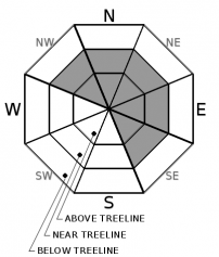
 The potentially problematic buried weak layer as seen on Nov 16 on Relay Peak (Mount Rose zone).

Weather and CURRENT CONDITIONS
weather summary

High intensity precipitation is expected to continue across the forecast area through this afternoon, tapering this evening. Snow level fluctuated between 6,100' and 7,000' last night. New snow has steadily accumulated at 7,000' and above. Gale force SW winds have started to decrease in speed from yesterday but will remain strong today with continued ridgetop gusts to 100 mph possible. Precipitation and winds are forecast to taper off around midnight tonight. For tomorrow expect partly cloudy skies and moderate speed SW winds.

CONDITIONS ALONG THE SIERRA CREST BETWEEN 8200 FT. AND 9200 FT. IN THE LAST 24 HOURS
6am temperature: 24 to 29 deg. F.
Max. temperature: 41 to 44 deg. F.
Average ridgetop wind direction: SW
Average ridgetop wind speed: 58 mph
Maximum ridgetop wind gust: 99 mph
New snowfall: 9 to 12 inches
Total snow depth: 15 to 24 inches
Two-Day Mountain Weather Forecast Produced in partnership with the Reno NWS
For 7000 ft. to 8000 ft.
Wednesday Wednesday Night Thursday
Weather: Cloudy. Snow. Snow levels 7,000'. Chance of precipitation is 95%. Mostly cloudy then becoming partly cloudy. Snow likely in the evening, then slight chance of snow after midnight. Snow levels below 7,000'. Chance of precipitation is 65%. Partly cloudy. Snow levels below 7,000'. Chance of precipitation is 0%.
Temperatures: 33 to 39 deg. F. 23 to 29 deg. F. 34 to 39 deg. F.
Mid Slope Winds: Southwest 15 to 30 mph with gusts to 60 mph. Southwest 15 to 30 mph. Gusts up to 60 mph decreasing to 45 mph after midnight. Light winds.
Expected snowfall: 75% probability of 5 to 10 inches. 25% probability of 3 to 7 inches. | SWE = 0.75 to 1.25 inches 60% probability up to 4 inches. 40% probability up to 2 inches.| SWE = Up to 0.30 inch No accumulation. | SWE = none
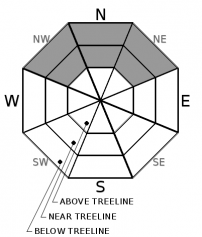
For 8000 ft. to 9000 ft.
Wednesday Wednesday Night Thursday
Weather: Cloudy. Snow. Snow levels 7,000'. Chance of precipitation is 95%. Mostly cloudy. Snow likely in the evening, then slight chance of snow after midnight. Snow levels below 7,000'. Chance of precipitation is 65% Partly cloudy. Snow levels below 7,000'. Chance of precipitation is 0%
Temperatures: 28 to 34 deg. F. 21 to 26 deg. F. 29 to 35 deg. F.
Ridge Top Winds: Southwest 35 to 55 mph decreasing to 30 to 45 mph in the afternoon. Gusts up to 100 mph. Southwest 30 to 50 mph with gusts to 90 mph. Southwest 15 to 30 mph. Gusts up to 65 mph decreasing to 40 mph in the afternoon.
Expected snowfall: 75% probability of 8 to 16 inches. 25% probability of 4 to 8 inches.| SWE = 1.00-1.50 inches 60% probability of 1 to 5 inches. 40% probability up to 2 inches. | SWE = 0.15-0.40 inch No accumulation. | SWE = none
Disclaimer

This avalanche forecast is provided through a partnership between the Tahoe National Forest and the Sierra Avalanche Center. This forecast covers the Central Sierra Nevada Mountains between Yuba Pass on the north and Ebbetts Pass on the south. Click here for a map of the forecast area. This forecast applies only to backcountry areas outside established ski area boundaries. This forecast describes general avalanche conditions and local variations always occur. This forecast expires 24 hours after the posted time unless otherwise noted. The information in this forecast is provided by the USDA Forest Service who is solely responsible for its content.

For a recorded version of the avalanche forecast call (530) 587-3558 x258