THIS AVALANCHE FORECAST EXPIRED ON November 20, 2020 @ 7:00 am
Avalanche Forecast published on November 19, 2020 @ 7:00 am
Issued by Steve Reynaud - Tahoe National Forest

Early season conditions exist across the forecast region with a shallow snowpack and many rocks, bushes, and trees present.  Human triggered avalanches remain possible today with wind slab and persistent slab avalanche problems at all elevations.  Look for unstable snow on specific terrain features and use cautious travel protocols due to low snow conditions.  

2. Moderate

?

Above Treeline
Heightened avalanche conditions on specific terrain features. Evaluate snow and terrain carefully; identify features of concern.

2. Moderate

?

Near Treeline
Heightened avalanche conditions on specific terrain features. Evaluate snow and terrain carefully; identify features of concern.

2. Moderate

?

Below Treeline
Heightened avalanche conditions on specific terrain features. Evaluate snow and terrain carefully; identify features of concern.
    Heightened avalanche conditions on specific terrain features. Evaluate snow and terrain carefully; identify features of concern.
Avalanche Problem 1: Wind Slab
  • Type ?
  • Aspect/Elevation ?
  • Likelihood ?
    Certain
    Very Likely
    Likely
    Possible
    Unlikely
  • Size ?
    Historic
    Very Large
    Large
    Small

Reactive wind slabs formed yesterday in near and above treeline areas with dense storm snow and strong to gale force winds.  These strong to gale force SW/S winds have continued overnight and will remain today before decreasing later this afternoon.  Sensitive wind slabs from yesterday could grow larger and remain reactive today along with additional new wind slabs forming.

Look for blowing snow, cornice formation, wind pillows, and evidence of previous wind loading from yesterday.  Dense heavy snow over less dense snow and any snow surface cracking could be indications of unstable snow.  Areas below cornices and wind features will be of concern today.     

Avalanche Problem 2: Persistent Slab
  • Type ?
  • Aspect/Elevation ?
  • Likelihood ?
    Certain
    Very Likely
    Likely
    Possible
    Unlikely
  • Size ?
    Historic
    Very Large
    Large
    Small

Weak snow formed during cold conditions after our first snow of the season in early November.  This weak snow now sits near the base of our snowpack with 1-3 feet of snow from 2 additional storm cycles on top.  This persistent slab showed weakness yesterday in the Mt. Rose area with a slope fracturing remotely and numerous whumping noises throughout the area.  We have found this layer to be weak above around 8300', in below and near treeline terrain on NW-N-NE aspects and has shown to be weaker at upper elevations. 

This weak layer does not exist everywhere and numerous anchors ( rocks, bushes, trees) are helping to break up this weak layer across slopes and help hold it in place in some areas.  Previous NE/E winds have scoured away much of this weak layer in wind exposed terrain.  Whumping noises, cracking, or recent avalanches would indicate unstable snow in the immediate area.  With this persistent slab, remote triggering, mid slope avalanches, and the potential for avalanches occurring even after multiple users have tracks on a slope, are all possible.  An avalanche associated with this weak layer would have high consequences of hitting numerous exposed obstacles.    

recent observations

A slope fractured on Relay Peak in the Mt. Rose area failing on the Nov 13 facet layer.  Numerous whumping sounds and cracking were also encountered throughout this area.  Small wind slabs were reactive in near treeline terrain on small test slopes with up to intense snow transport observed along exposed ridges.

Observations from Grouse Rock in Ward Canyon had snow levels around 7500', with dense heavy storm snow and moderate to intense wind transport.

Weak snow developed between the Nov 7 and the Nov 13 storm cycles and is buried around 4-8'' above ground level.  This snow is weakest on NW-N-NE aspects above around 8300' on below and near treeline terrain that was not previously wind scoured by NE/E winds.

Slope fracture on small terrain above creekbed, failing on the Nov 13 facet layer.

Weather and CURRENT CONDITIONS
weather summary

15 to 26'' of storm snow was reported above 8000' since Tuesday evening with a snow/rain mix and decreased snowfall below 7500'.  Partly sunny with increasing cloudy skies are forecasted today with continued strong SW winds decreasing  this afternoon.  A break in the storm activity will occur over the next few days with the chance of some smaller storms for our area next week.  

CONDITIONS ALONG THE SIERRA CREST BETWEEN 8200 FT. AND 9200 FT. IN THE LAST 24 HOURS
6am temperature: 19 to 21 deg. F.
Max. temperature: 29 to 32 deg. F.
Average ridgetop wind direction: SW
Average ridgetop wind speed: 35 to 55 mph
Maximum ridgetop wind gust: 108 mph
New snowfall: 6 to 13 inches
Total snow depth: 18 to 24 inches
Two-Day Mountain Weather Forecast Produced in partnership with the Reno NWS
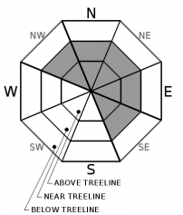
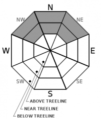
For 7000 ft. to 8000 ft.
Thursday Thursday Night Friday
Weather: Partly cloudy. Snow levels below 7000 feet. Chance of precipitation is 0%. Partly cloudy. Snow levels below 7000 feet. Chance of precipitation is 0%. Partly cloudy. Snow levels below 7000 feet. Chance of precipitation is 0%.
Temperatures: 34 to 39. deg. F. 17 to 25. deg. F. 35 to 41. deg. F.
Mid Slope Winds: Southwest winds 10 to 15 mph with gusts to 25 mph becoming light in the afternoon. East winds to 10 mph. East winds to 10 mph becoming light in the afternoon.
Expected snowfall: No accumulation. | SWE = none. No accumulation. | SWE = none. No accumulation. | SWE = none.
For 8000 ft. to 9000 ft.
Thursday Thursday Night Friday
Weather: Partly cloudy. Snow levels below 7000 feet. Chance of precipitation is 0%. Partly cloudy. Snow levels below 7000 feet. Chance of precipitation is 0%. Partly cloudy. Snow levels below 7000 feet. Chance of precipitation is 0%.
Temperatures: 29 to 35. deg. F. 17 to 23. deg. F. 31 to 37. deg. F.
Ridge Top Winds: Southwest 20 to 30 mph with gusts to 50 mph becoming south around 15 mph with gusts to 25 mph in the afternoon. Southeast around 15 mph with gusts to 30 mph. South around 15 mph with gusts to 30 mph.
Expected snowfall: No accumulation. | SWE = none. No accumulation. | SWE = none. No accumulation. | SWE = none.
Disclaimer

This avalanche forecast is provided through a partnership between the Tahoe National Forest and the Sierra Avalanche Center. This forecast covers the Central Sierra Nevada Mountains between Yuba Pass on the north and Ebbetts Pass on the south. Click here for a map of the forecast area. This forecast applies only to backcountry areas outside established ski area boundaries. This forecast describes general avalanche conditions and local variations always occur. This forecast expires 24 hours after the posted time unless otherwise noted. The information in this forecast is provided by the USDA Forest Service who is solely responsible for its content.

For a recorded version of the avalanche forecast call (530) 587-3558 x258