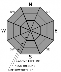
THIS AVALANCHE FORECAST EXPIRED ON November 25, 2020 @ 6:52 am
Avalanche Forecast published on November 24, 2020 @ 6:52 am
Issued by Steve Reynaud - Tahoe National Forest

LOW avalanche danger continues with normal caution advised when traveling in the backcountry.  Early season conditions exist with thin snow coverage throughout the forecast region.

1. Low

?

Above Treeline
Generally safe avalanche conditions. Watch for unstable snow on isolated terrain features.

1. Low

?

Near Treeline
Generally safe avalanche conditions. Watch for unstable snow on isolated terrain features.

1. Low

?

Below Treeline
Generally safe avalanche conditions. Watch for unstable snow on isolated terrain features.
    Generally safe avalanche conditions. Watch for unstable snow on isolated terrain features.
Avalanche Problem 1: Normal Caution
  • Type ?
  • Aspect/Elevation ?
  • Likelihood ?
    Certain
    Very Likely
    Likely
    Possible
    Unlikely
  • Size ?
    Historic
    Very Large
    Large
    Small

Early season conditions dominate the forecast area with limited terrain available for over the snow recreation.  Thin snowpack coverage, with many rocks, bushes, dirt, and trees poking out of the snow that could be hit, remains the main hazard for backcountry travel.  A mostly supportable snowpack on upper elevation northerly aspects does provide decent travel conditions and avoidance of many of these obstacles.  Light to moderate NE winds today are not expected to transport snow and be a concern.  Winds are set to switch back to the SW late tonight and increase into the strong to gale force range into Wednesday.  Normal caution is advised when traveling in the backcountry.  Maintain awareness of the changing snow conditions as you move through terrain.   

recent observations

Mostly supportable snow conditions exist above 8600' in the Mt. Rose area and above 7300-7800' along the Sierra Crest on northerly aspects.  Snow melt and loss has occurred on southerly aspects with more exposed obstacles or bare dirt in these areas.  The snowpack is around 1-2 feet deep and continues to settle and gain strength.  Weaknesses at or near the snow surface will need to be monitored as a future problem when our next snow storm arrives.    

Weather and CURRENT CONDITIONS
weather summary

Sunny skies, warming temperatures, with light to moderate NE winds are forecasted for today.  Winds will switch late tonight to the SW and increase ahead of a low pressure storm passing towards our north.  An inch to a couple inches of new snow could be possible out of this storm for Wednesday along with strong to gale force SW winds.  Thursday clears back out with warming temperatures and decreasing winds into the weekend.

CONDITIONS ALONG THE SIERRA CREST BETWEEN 8200 FT. AND 9200 FT. IN THE LAST 24 HOURS
6am temperature: 27 to 29 deg. F.
Max. temperature: 33 to 39 deg. F.
Average ridgetop wind direction: NE/E
Average ridgetop wind speed: 15 to 25 mph
Maximum ridgetop wind gust: 40 mph
New snowfall: 0 inches
Total snow depth: 16 to 21 inches
Two-Day Mountain Weather Forecast Produced in partnership with the Reno NWS
For 7000 ft. to 8000 ft.
Tuesday Tuesday Night Wednesday
Weather: Sunny. Snow levels below 7000 feet. Chance of precipitation is 0%. Clear. Snow levels 7000 feet decreasing to below 7000 feet after midnight. Chance of precipitation is 0%. Partly cloudy. Slight chance of snow showers. Snow levels below 7000 feet. Chance of precipitation is 25%.
Temperatures: 39 to 44. deg. F. 23 to 29. deg. F. 32 to 38. deg. F.
Mid Slope Winds: Light winds. Light winds becoming southwest 15 to 20 mph with gusts to 35 mph after midnight. Southwest 15 to 20 mph with gusts up to 35 mph.
Expected snowfall: No accumulation. | SWE = none. No accumulation. | SWE = none. Up to 1 inch. | SWE = less than 0.10 inch.
For 8000 ft. to 9000 ft.
Tuesday Tuesday Night Wednesday
Weather: Sunny. Snow levels below 7000 feet increasing to 7000 feet in the afternoon. Chance of precipitation is 0%. Clear. Snow levels 7000 feet decreasing to below 7000 feet after midnight. Chance of precipitation is 0%. Partly cloudy. Slight chance of snow showers through the day. Snow levels below 7000 feet. Chance of precipitation is 25%.
Temperatures: 35 to 40. deg. F. 22 to 27. deg. F. 28 to 33. deg. F.
Ridge Top Winds: Northeast 15 to 20 mph with gusts to 35 mph. Southwest around 15 mph with gusts to 25 mph increasing to 30 to 45 mph with gusts to 80 mph after midnight. Southwest 30 to 45 mph with gusts up to 80 mph.
Expected snowfall: No accumulation. | SWE = none. No accumulation. | SWE = none. Up to 1 inch. | SWE = less than 0.10 inch.
Disclaimer

This avalanche forecast is provided through a partnership between the Tahoe National Forest and the Sierra Avalanche Center. This forecast covers the Central Sierra Nevada Mountains between Yuba Pass on the north and Ebbetts Pass on the south. Click here for a map of the forecast area. This forecast applies only to backcountry areas outside established ski area boundaries. This forecast describes general avalanche conditions and local variations always occur. This forecast expires 24 hours after the posted time unless otherwise noted. The information in this forecast is provided by the USDA Forest Service who is solely responsible for its content.

For a recorded version of the avalanche forecast call (530) 587-3558 x258