THIS AVALANCHE FORECAST EXPIRED ON November 28, 2020 @ 6:48 am
Avalanche Forecast published on November 27, 2020 @ 6:48 am
Issued by Andy Anderson - Tahoe National Forest - Sierra Avalanche Center

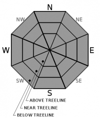
Shallow early season conditions with lots of exposed and barely covered obstacles and firm scoured snow surfaces in some places will represent today's main concerns. LOW avalanche danger exists at all elevations. Normal caution is advised 

1. Low

?

Above Treeline
Generally safe avalanche conditions. Watch for unstable snow on isolated terrain features.

1. Low

?

Near Treeline
Generally safe avalanche conditions. Watch for unstable snow on isolated terrain features.

1. Low

?

Below Treeline
Generally safe avalanche conditions. Watch for unstable snow on isolated terrain features.
    Generally safe avalanche conditions. Watch for unstable snow on isolated terrain features.
Avalanche Problem 1: Normal Caution
  • Type ?
  • Aspect/Elevation ?
  • Likelihood ?
    Certain
    Very Likely
    Likely
    Possible
    Unlikely
  • Size ?
    Historic
    Very Large
    Large
    Small

The snowpack remains thin. Collisions with obstacles like trees, stumps, rocks, logs, etc could cause problems for backcountry travelers. These collisions could result from a fall and loss of control while traveling on firm scoured surfaces or from simply running into something while moving at speed. On the plus side, the shallow snowpack is mostly supportable. Being observant and moving on lower angle slopes at slower speeds can help identify and avoid many of the obstacles. Avalanche activity will remain unlikely today. 

Early season represents a great time to practice avalanche rescue skills, route finding, and terrain identification. Start the season off by practicing safe travel strategies and make them a habit for the rest of the year.

recent observations

Overall the snowpack remains shallow but supportable in most places. Northerly aspects above 8600 ft in the Mt Rose backcountry and above 7800 ft. along the Sierra Crest hold the best coverage with more snow in the northern part of the forecast area. Variable snow surface conditions exist throughout the forecast area with scoured surfaces on slopes exposed to the east winds and patchy snow on sun-exposed aspects where significant snowmelt has occurred. Some soft surface snow (near-surface facets) may still exist in sheltered areas on northerly aspects.

Weather and CURRENT CONDITIONS
weather summary

The strong east winds peaked in the last 24 hours with gusts well over 100 mph in some places on the Sierra Crest. Temperatures have also been on a warming trend with this morning's temperatures representing the high temperatures in the last 24 hours in many places above 8000 ft. A high-pressure ridge building over the forecast area should cause the east winds to continue to decrease and the temperatures to continue to increase today. Expect seasonal temperatures and sunny calm weather for the next few days. 

CONDITIONS ALONG THE SIERRA CREST BETWEEN 8200 FT. AND 9200 FT. IN THE LAST 24 HOURS
6am temperature: 24 to 29 deg. F.
Max. temperature: 24 to 32 deg. F.
Average ridgetop wind direction: NE to E
Average ridgetop wind speed: 50 to 70 mph
Maximum ridgetop wind gust: 121 to 161 mph
New snowfall: 0 inches
Total snow depth: 15 to 20 inches
Two-Day Mountain Weather Forecast Produced in partnership with the Reno NWS
For 7000 ft. to 8000 ft.
Friday Friday Night Saturday
Weather: Sunny. Snow levels below 7000 feet. Chance of precipitation is 0%. Clear. Snow levels below 7000 feet. Chance of precipitation is 0%. Sunny. Snow levels below 7000 feet. Chance of precipitation is 0%.
Temperatures: 34 to 40 deg. F. 21 to 27 deg. F. 42 to 47 deg. F.
Mid Slope Winds: Light winds. Gusts up to 35 mph in the morning. Light winds. Light winds.
Expected snowfall: No accumulation. | SWE = none. No accumulation. | SWE = none. No accumulation. | SWE = none.
For 8000 ft. to 9000 ft.
Friday Friday Night Saturday
Weather: Sunny. Snow levels below 7000 feet. Chance of precipitation is 0%. Clear. Snow levels below 7000 feet. Chance of precipitation is 0%. Sunny. Snow levels below 7000 feet. Chance of precipitation is 0%.
Temperatures: 32 to 37 deg. F. 22 to 27 deg. F. 37 to 43 deg. F.
Ridge Top Winds: East 15 to 20 mph with gusts to 45 mph in the morning becoming light. Light winds. Light winds.
Expected snowfall: No accumulation. | SWE = none. No accumulation. | SWE = none. No accumulation. | SWE = none.
Disclaimer

This avalanche forecast is provided through a partnership between the Tahoe National Forest and the Sierra Avalanche Center. This forecast covers the Central Sierra Nevada Mountains between Yuba Pass on the north and Ebbetts Pass on the south. Click here for a map of the forecast area. This forecast applies only to backcountry areas outside established ski area boundaries. This forecast describes general avalanche conditions and local variations always occur. This forecast expires 24 hours after the posted time unless otherwise noted. The information in this forecast is provided by the USDA Forest Service who is solely responsible for its content.

For a recorded version of the avalanche forecast call (530) 587-3558 x258