THIS AVALANCHE FORECAST EXPIRED ON November 30, 2020 @ 6:50 am
Avalanche Forecast published on November 29, 2020 @ 6:50 am
Issued by Brandon Schwartz - Tahoe National Forest

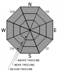
Normal caution tactics are advised for any travel in avalanche terrain at this time. Anticipate shallow snowcover, early season conditions. Avalanche danger is LOW for all elevations.

1. Low

?

Above Treeline
Generally safe avalanche conditions. Watch for unstable snow on isolated terrain features.

1. Low

?

Near Treeline
Generally safe avalanche conditions. Watch for unstable snow on isolated terrain features.

1. Low

?

Below Treeline
Generally safe avalanche conditions. Watch for unstable snow on isolated terrain features.
    Generally safe avalanche conditions. Watch for unstable snow on isolated terrain features.
Avalanche Problem 1: Normal Caution
  • Type ?
  • Aspect/Elevation ?
  • Likelihood ?
    Certain
    Very Likely
    Likely
    Possible
    Unlikely
  • Size ?
    Historic
    Very Large
    Large
    Small

No specific avalanche problems exist at this time. Normal caution tactics and companion rescue gear are advised for any travel in avalanche terrain today. Anticipate encountering lots of obstacles buried shallow in the snowpack. Slowing down and sticking to conservative route choices will help you avoid hitting them. Conditions right now are pretty good for practicing companion rescue.

recent observations

Snowpit data and other field observations indicate that avalanches are unlikely at this time. The existing snowpack is shallow but supportable for over snow travel. Numerous obstacles such as rocks, logs, etc are usually easily avoidable with a little care (i.e. slower speeds and conservative route choices). In areas protected from wind and sun, faceting processes are at work, especially on the upper portion of the snowpack. In sun exposed areas melt-freeze has affected the snow surface. In wind exposed areas, some scouring has occurred with rough (sastrugi) and sometimes firm snow surface conditions. Historically, some of our most problematic weak layers tend to form during dry spells such as the current one, so snowpack monitoring remains ongoing.

Weather and CURRENT CONDITIONS
weather summary

High pressure is in place over the forecast area. Air temperature inversion conditions have the coldest air on the mountain valley floors this morning rather than at the mid and upper elevations. Mainly light winds are forecast for today with the occasional moderate gust this afternoon. SW winds increase tonight and tomorrow ahead of an approaching dry cold front. This increase in winds is expected to mix out inversion conditions for increased warming at the low and mid elevations tomorrow. A slight cool down and a shift back to NE winds are forecast for Tuesday.

CONDITIONS ALONG THE SIERRA CREST BETWEEN 8200 FT. AND 9200 FT. IN THE LAST 24 HOURS
6am temperature: 30 to 36 deg. F.
Max. temperature: 43 to 54 deg. F.
Average ridgetop wind direction: E
Average ridgetop wind speed: 17 mph
Maximum ridgetop wind gust: 27 mph
New snowfall: 0 inches
Total snow depth: 14 to 19 inches
Two-Day Mountain Weather Forecast Produced in partnership with the Reno NWS
For 7000 ft. to 8000 ft.
Sunday Sunday Night Monday
Weather: Partly cloudy. Snow levels below 7000 feet. Chance of precipitation is 0%. Partly cloudy then becoming mostly cloudy. Snow levels below 7000 feet. Chance of precipitation is 0%. Mostly cloudy then becoming sunny. Snow levels below 7000 feet. Chance of precipitation is 0%.
Temperatures: 40 to 46. deg. F. 23 to 31. deg. F. 42 to 47. deg. F.
Mid Slope Winds: Light winds. Light winds becoming southwest around 15 mph after midnight. Gusts up to 25 mph. Light winds. Gusts up to 30 mph in the morning.
Expected snowfall: No accumulation. | SWE = none. No accumulation. | SWE = none. No accumulation. | SWE = none.
For 8000 ft. to 9000 ft.
Sunday Sunday Night Monday
Weather: Partly cloudy. Snow levels below 7000 feet. Chance of precipitation is 0%. Partly cloudy then becoming mostly cloudy. Snow levels below 7000 feet. Chance of precipitation is 0%. Mostly cloudy then becoming sunny. Snow levels below 7000 feet. Chance of precipitation is 0%.
Temperatures: 37 to 43. deg. F. 23 to 29. deg. F. 37 to 43. deg. F.
Ridge Top Winds: Light winds. Gusts up to 25 mph in the afternoon. Southwest 15 to 20 mph with gusts to 30 mph. West around 15 mph with gusts to 30 mph.
Expected snowfall: No accumulation. | SWE = none. No accumulation. | SWE = none. No accumulation. | SWE = none.
Disclaimer

This avalanche forecast is provided through a partnership between the Tahoe National Forest and the Sierra Avalanche Center. This forecast covers the Central Sierra Nevada Mountains between Yuba Pass on the north and Ebbetts Pass on the south. Click here for a map of the forecast area. This forecast applies only to backcountry areas outside established ski area boundaries. This forecast describes general avalanche conditions and local variations always occur. This forecast expires 24 hours after the posted time unless otherwise noted. The information in this forecast is provided by the USDA Forest Service who is solely responsible for its content.

For a recorded version of the avalanche forecast call (530) 587-3558 x258