THIS AVALANCHE FORECAST EXPIRED ON January 3, 2021 @ 6:58 am
Avalanche Forecast published on January 2, 2021 @ 6:58 am
Issued by Andy Anderson - Tahoe National Forest - Sierra Avalanche Center

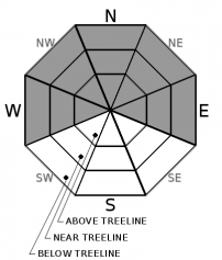
Triggering an avalanche on steep slopes still remains possible today especially in places with a shallower snowpack and old weak snow below the surface. Some fragile slabs of wind drifted snow may also exist in wind-affected terrain. MODERATE avalanche danger exists at all elevations. Conservative terrain choices are recommended when traveling in the backcountry.

2. Moderate

?

Above Treeline
Heightened avalanche conditions on specific terrain features. Evaluate snow and terrain carefully; identify features of concern.

2. Moderate

?

Near Treeline
Heightened avalanche conditions on specific terrain features. Evaluate snow and terrain carefully; identify features of concern.

2. Moderate

?

Below Treeline
Heightened avalanche conditions on specific terrain features. Evaluate snow and terrain carefully; identify features of concern.
    Heightened avalanche conditions on specific terrain features. Evaluate snow and terrain carefully; identify features of concern.
Avalanche Problem 1: Persistent Slab
  • Type ?
  • Aspect/Elevation ?
  • Likelihood ?
    Certain
    Very Likely
    Likely
    Possible
    Unlikely
  • Size ?
    Historic
    Very Large
    Large
    Small

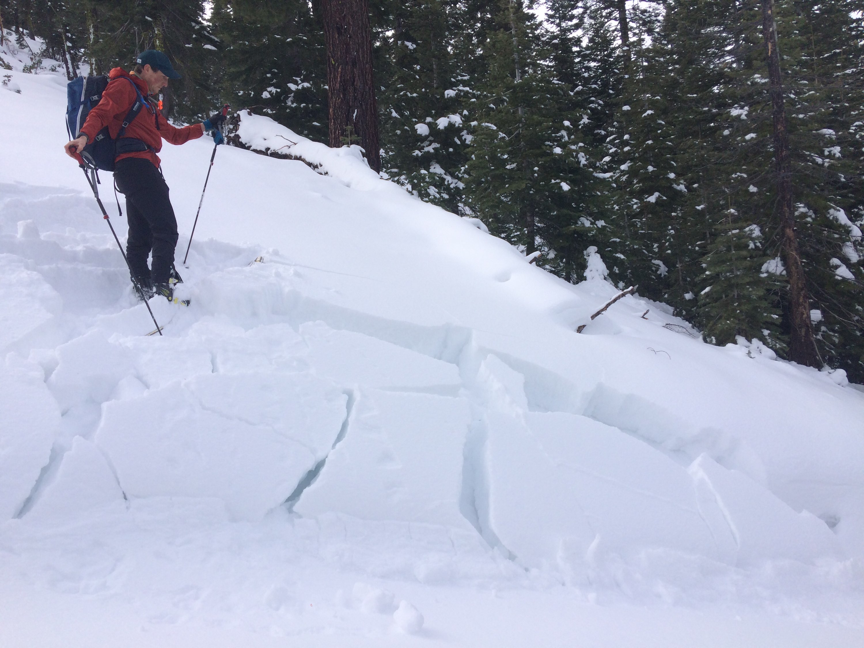
The likelihood of triggering an avalanche has decreased in many areas. However, persistent slab avalanches do remain possible in some places especially in areas where the weak layer sits closer to the surface. A person hitting just the right spot (trigger point) on a slope or larger triggers like multiple people on a slope of a large cornice failure could also be more problematic. Persistent weak layers do not gain strength uniformly. Most data indicates that the old weak snow buried in the snowpack continues to adjust to the weight of the snow above it, but some data like the whumpfing and test slope failure reported yesterday from Brockway Summit indicate that the Dec 11 facets remain active.

Persistent slabs behave in unpredictable ways. Signs of instability like whumpfing, cracking, and unstable snowpack test results may or may not exist. Sometimes triggering a large avalanche represents the first and only clue that the slope is unstable. Travel plans built around terrain less steep than 30 degrees not connected to steeper slopes or terrain without the weak layer can provide fun recreation opportunities with significantly higher safety margins. In many cases, those slopes hold great snow conditions right now.  While this problem will be here for a while longer, it won't last forever. Be patient, the bigger, steeper terrain will still be here after the persistent slab problem goes away. 

Test Slope Failure on a N facing below treeline slope on Brockway Summit 1/1/2021

Test Slope Failure on a N facing below treeline slope on Brockway Summit 1/1/2021.

Avalanche Problem 2: Wind Slab
  • Type ?
  • Aspect/Elevation ?
  • Likelihood ?
    Certain
    Very Likely
    Likely
    Possible
    Unlikely
  • Size ?
    Historic
    Very Large
    Large
    Small

Another bout of strong SW winds over the last 24 hours should have moved snow back across the ridges and built slabs of drifted snow on wind-loaded slopes. Some wind transport may continue today. For the most part, these wind slabs should remain small, but some larger ones could exist on the most heavily wind-loaded slopes. Human-triggered wind slabs will be possible today. 

Newly developed cornices, wind pillows, and wind created surface textures can all help to identify which slopes may hold wind slabs. Identifying where these wind slabs may exist only represents part of the strategy right now since the persistent slabs mentioned above may exist in the more sheltered terrain.

recent observations

* Widespread whumpfing and one test slope failure occurred on below treeline N facing terrain near Brockway Summit yesterday. The failure occurred on the Dec. 11 facet layer. The snowpack in this area is more shallow than in other places around the forecast area.  

* Data and observations over the last 2 days from Indian Valley (near Ebbetts Pass), Becker Peak (near Echo Summit), Stoney Ridge (West Shore), Munchkins and Poulson Peak (Hwy 89 between Tahoe City and Truckee), Donner Summit, and near Independence Lake mostly indicate that the snowpack continues to gain strength. The Dec 11 facets remain buried in the snowpack but they are adjusting to the load above them. The same is true of the interface at the bottom of the 12/25 snow.   

* Reports of shallowly buried surface hoar on sheltered slopes have come in from some areas around the forecast region.

* Observers reported soft cold snow on northerly aspects with warmer wetter snow on sunny more southerly aspects

Weather and CURRENT CONDITIONS
weather summary

Wind speeds peaked during the night as a weak system moved past the forecast area to the north. The winds should remain out of the SW through the weekend as more weak weather disturbances pass by. These systems will also bring a slight chance for some light snow but no appreciable accumulation is expected. The forecast calls for the next significant storm system to arrive on Monday. Check-in with the Reno NWS for more details.

CONDITIONS ALONG THE SIERRA CREST BETWEEN 8200 FT. AND 9200 FT. IN THE LAST 24 HOURS
6am temperature: 22 to 29 deg. F.
Max. temperature: 39 to 45 deg. F.
Average ridgetop wind direction: SW
Average ridgetop wind speed: 25 to 35 mph
Maximum ridgetop wind gust: 73 mph
New snowfall: 0 inches
Total snow depth: 29 to 36 inches
Two-Day Mountain Weather Forecast Produced in partnership with the Reno NWS
For 7000 ft. to 8000 ft.
Saturday Saturday Night Sunday
Weather: Mostly cloudy. Snow levels below 7000 feet. Chance of precipitation is 5%. Cloudy. Slight chance of snow showers after midnight. Snow levels below 7000 feet. Chance of precipitation is 20%. Mostly cloudy. Snow levels below 7000 feet. Chance of precipitation is 10%.
Temperatures: 33 to 38 deg. F. 25 to 30 deg. F. 36 to 41 deg. F.
Mid Slope Winds: Southwest 15 to 20 mph with gusts to 40 mph. Southwest around 15 mph with gusts to 40 mph. Southwest around 15 mph with gusts to 40 mph in the morning becoming light.
Expected snowfall: No accumulation. | SWE = none. Up to 1 inch. | SWE = less than 0.10 inch. Up to 1 inch. | SWE = none.
For 8000 ft. to 9000 ft.
Saturday Saturday Night Sunday
Weather: Mostly cloudy. Snow levels below 7000 feet. Chance of precipitation is 5%. Cloudy. Slight chance of snow showers after midnight. Snow levels below 7000 feet. Chance of precipitation is 15%. Mostly cloudy. Snow levels below 7000 feet increasing to 7000 feet in the afternoon. Chance of precipitation is 10%.
Temperatures: 29 to 34 deg. F. 23 to 28 deg. F. 32 to 38 deg. F.
Ridge Top Winds: Southwest 15 to 30 mph. Gusts up to 55 mph decreasing to 45 mph in the afternoon. Southwest 20 to 30 mph with gusts to 70 mph. Southwest 15 to 30 mph with gusts to 60 mph.
Expected snowfall: No accumulation. | SWE = none. Up to 1 inch. | SWE = less than 0.10 inch. Up to 1 inch. | SWE = none.
Disclaimer

This avalanche forecast is provided through a partnership between the Tahoe National Forest and the Sierra Avalanche Center. This forecast covers the Central Sierra Nevada Mountains between Yuba Pass on the north and Ebbetts Pass on the south. Click here for a map of the forecast area. This forecast applies only to backcountry areas outside established ski area boundaries. This forecast describes general avalanche conditions and local variations always occur. This forecast expires 24 hours after the posted time unless otherwise noted. The information in this forecast is provided by the USDA Forest Service who is solely responsible for its content.

For a recorded version of the avalanche forecast call (530) 587-3558 x258