THIS AVALANCHE FORECAST EXPIRED ON January 5, 2021 @ 6:54 am
Avalanche Forecast published on January 4, 2021 @ 6:54 am
Issued by Brandon Schwartz - Tahoe National Forest

Rapid new snow loading, drifting snow from gale force winds, and the stressing of older weak layers within the existing snowpack will create very dangerous avalanche conditions today. Avoid travel in, below, or adjacent to avalanche terrain. A rapid increase to HIGH avalanche danger will occur for all elevations today.

4. High

?

Above Treeline
Very dangerous avalanche conditions. Travel in avalanche terrain not recommended.

4. High

?

Near Treeline
Very dangerous avalanche conditions. Travel in avalanche terrain not recommended.

4. High

?

Below Treeline
Very dangerous avalanche conditions. Travel in avalanche terrain not recommended.
    Very dangerous avalanche conditions. Travel in avalanche terrain not recommended.
Avalanche Problem 1: Persistent Slab
  • Type ?
  • Aspect/Elevation ?
  • Likelihood ?
    Certain
    Very Likely
    Likely
    Possible
    Unlikely
  • Size ?
    Historic
    Very Large
    Large
    Small

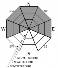
There are several weak layers within the existing snowpack ranging from the Dec 11 PWL to buried surface hoar that are expected to be stressed to the point of failure today under rapid new snow loading. Persistent slab avalanches failing within the old snow are expected to have wide propagation and could be rather large and destructive today. Avalanches could be triggered from low angle areas near the bottom of a slope or from the side on an adjacent lower angle slope. Persistent slab avalanches are most likely today near treeline or below treeline on W-NW-N-NE-E aspects and to a lesser extent above treeline as well.

While avoiding avalanche terrain today, keep well away from avalanche runout zones and pre-plan for how you are going to avoid avalanche terrain when poor visibility obscures the view of the terrain around you. Keep in mind that instability will rapidly rise as the day progresses and how that may affect a return route.

Avalanche Problem 2: Wind Slab
  • Type ?
  • Aspect/Elevation ?
  • Likelihood ?
    Certain
    Very Likely
    Likely
    Possible
    Unlikely
  • Size ?
    Historic
    Very Large
    Large
    Small

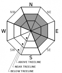
Rapid new snow loading combined with gale force SW winds over ridgetops will create widespread areas of drifting snow deposits and new wind slabs in lee areas.  Wind slab avalanches are most likely to occur today above treeline and near treeline on NW-N-NE-E-SE aspects but could occur in any areas where drifting snow is deposited.

Give cornice areas a wide berth. Ridgetop travel that avoids avalanche terrain could be difficult today due to gale force winds and poor visibiity. Keep in mind that instability will rapidly rise as the day progresses.

Avalanche Problem 3: Storm Slab
  • Type ?
  • Aspect/Elevation ?
  • Likelihood ?
    Certain
    Very Likely
    Likely
    Possible
    Unlikely
  • Size ?
    Historic
    Very Large
    Large
    Small

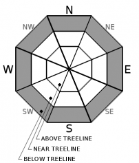
High intensity snowfall today is expected to create unstable layers within the new snow. Avalanches failing on these layers could occur in wind protected areas below treeline on any aspect. Don't expect "in the trees" to be a safe place from avalanches today. Persistent slab and storm slab avalanches are a good bet below treeline today. Avoid avalanche terrain.

recent observations

* The Dec 11 PWL gained some strength since the last storm but an overall poor snowpack structure remains. Recent snowpit data from around the forecast area indicates that this layer will likely become unstable again today under rapid new snow loading.

* Surface hoar buried a few inches below the old snow surface has been reported from some locations.

Weather and CURRENT CONDITIONS
weather summary

A storm system passing through the forecast area today will bring a period of high intensity snowfall along with gale force SW ridgetop winds. The main period of snow accumulation will occur between 10 am and 6 pm. Snowfall rates are expected at 2+ inches per hour during this time with the atmospheric potential for lightning strikes. Substantial new snow accumulation is expected during this time period unless snow levels rise higher than forecast or precipitation shuts off sooner than forecast. Snow level is expected around 6,500' to 7,000' through this morning, lowering during the mid to late afternoon hours. A break in the weather is forecast for tomorrow with sunny skies and decreasing winds. The next weather system is expected to affect the region on Wednesday.

CONDITIONS ALONG THE SIERRA CREST BETWEEN 8200 FT. AND 9200 FT. IN THE LAST 24 HOURS
6am temperature: 28 to 32 deg. F.
Max. temperature: 32 to 39 deg. F.
Average ridgetop wind direction: SW
Average ridgetop wind speed: 28 mph
Maximum ridgetop wind gust: 72 mph
New snowfall: 1 to 2 inches
Total snow depth: 28 to 35 inches
Two-Day Mountain Weather Forecast Produced in partnership with the Reno NWS
For 7000 ft. to 8000 ft.
Monday Monday Night Tuesday
Weather: Cloudy. Chance of snow in the morning, then snow and slight chance of thunderstorms in the afternoon. Snow levels below 7000 feet. Chance of precipitation is 100%. Mostly cloudy then becoming clear. Snow likely in the evening. Slight chance of snow showers after midnight. Snow levels below 7000 feet. Chance of precipitation is 65%. Sunny skies. Snow levels below 7000 feet. Chance of precipitation is 0%.
Temperatures: 34 to 39 deg. F. 17 to 23 deg. F. 36 to 41 deg. F.
Mid Slope Winds: Southwest 15 to 25 mph with gusts to 45 mph increasing to 25 to 35 mph with gusts to 65 mph in the afternoon. Southwest 25 to 35 mph with gusts to 65 mph decreasing to 15 to 20 mph with gusts to 35 mph after midnight. Light winds.
Expected snowfall: 80% probability of 4 to 10 inches. 20% probability of 10 to 14 inches.| SWE = 0.50-1.00 inch 90% probability of 1 to 4 inches. 10% probability of 4 to 6 inches.| SWE = Up to 0.25 inch No accumulation | SWE = none
For 8000 ft. to 9000 ft.
Monday Monday Night Tuesday
Weather: Cloudy. Chance of snow in the morning, then snow and slight chance of thunderstorms in the afternoon. Snow levels below 7000 feet. Chance of precipitation is 100%. Mostly cloudy then becoming clear. Snow likely in the evening. Slight chance of snow showers after midnight. Snow levels below 7000 feet. Chance of precipitation is 70%. Sunny skies. Snow levels below 7000 feet. Chance of precipitation is 0%.
Temperatures: 30 to 35 deg. F. 16 to 21 deg. F. 32 to 38 deg. F.
Ridge Top Winds: Southwest 30 to 45 mph with gusts to 90 mph increasing to 50 to 75 mph with gusts to 125 mph in the afternoon. Southwest 40 to 60 mph with gusts to 110 mph decreasing to 25 to 35 mph with gusts to 75 mph after midnight. Southwest around 15 mph. Gusts up to 35 mph decreasing to 25 mph in the afternoon.
Expected snowfall: 70% probability of 4 to 10 inches. 30% probability of 10 to 16 inches. | SWE = 0.60-1.10 inches 80% probability up to 4 inches. 20% probability of 4 to 6 inches. | SWE = Up to 0.30 inch No accumulation | SWE = none
Disclaimer

This avalanche forecast is provided through a partnership between the Tahoe National Forest and the Sierra Avalanche Center. This forecast covers the Central Sierra Nevada Mountains between Yuba Pass on the north and Ebbetts Pass on the south. Click here for a map of the forecast area. This forecast applies only to backcountry areas outside established ski area boundaries. This forecast describes general avalanche conditions and local variations always occur. This forecast expires 24 hours after the posted time unless otherwise noted. The information in this forecast is provided by the USDA Forest Service who is solely responsible for its content.

For a recorded version of the avalanche forecast call (530) 587-3558 x258