In partnership with: 
|
December 18, 2008 at 7:59 am |
|
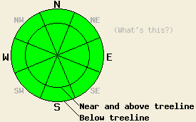
The avalanche danger is LOW for all elevations and aspects today. Expect the danger to increase as another storm impacts the forecast area tonight. |
|
|
|
Another cold, low pressure system should move in tonight bringing more wind and snow to the forecast area. Clouds have started to build ahead of this system. The winds have shifted to the southwest and started to increase. This system should bring another 1 to 2 feet of snow to the mountains above 7000' with the heaviest snowfall occurring late tonight and early Friday morning. Click here for a more detailed weather briefing from the NWS in Reno.
Since the end of the last storm on Tuesday, 4 to 6 inches of settlement has occurred in the snowpack. Observations from across the forecast area continue to show increasing strength in the snowpack and minimal slab formation. These observations indicate that avalanches should be difficult to trigger; however tests indicate that some fracture propagation potential still exists on the 11/26 facet layer below the new snow. Observers reported some very small wind slabs in the Carson Pass area on some of the most wind affected slopes. The clear, cold, and relatively calm weather since the end of the storm has allowed surface hoar to grow in some areas across the forecast area with crystals up to 3 cm across reported in the Sunrise Bowl area yesterday. If they are not destroyed by the wind before this next storm, these fragile feathery crystals could form a very weak layer when they are buried that could result in avalanche activity.
Today, avalanches should be unlikely because of the lack of slab formation and increasing strength in the snowpack. Even though avalanches are unlikely and increasingly hard to trigger today, be cautious because any avalanches that occur could involve large amounts of snow and collisions with large immovable objects like rocks and trees. Expect the avalanche danger to increase in the next 24 hours.
The avalanche danger is LOW for all elevations and aspects today. Expect the danger to increase as another storm impacts the forecast area tonight.
| 0600 temperature: | 8 deg. F. |
| Max. temperature in the last 24 hours: | 21 deg. F. |
| Average wind direction during the last 24 hours: | Northeast shifting to the west and southwest |
| Average wind speed during the last 24 hours: | 25-30 mph |
| Maximum wind gust in the last 24 hours: | 50 mph |
| New snowfall in the last 24 hours: | O inches |
| Total snow depth: | 28 inches |
For 7000-8000 ft: |
|||
| Thursday: | Thursday Night: | Friday: | |
| Weather: | Mostly cloudy with a chance of snow beginning later in the day. | Snow. | Steady snow in the morning tapering off to showers in the afternoon. |
| Temperatures: | 19-26 deg. F. | 15-20 deg. F. | 18-25 deg. F. |
| Wind direction: | West shifting to the southwest | Southwest | Southwest |
| Wind speed: | 10-15 mph in the morning increasing to 15-25 mph with gusts to 35 mph this afternoon. | 20-35 mph with gusts to 65 mph. | 25-35 mph with gusts to 85 mph in the morning decreasing to 15-25 mph with gusts to 45 mph in the afternoon. |
| Expected snowfall: | up to 2 in. | 8-12 in. | 4-8 in. |
For 8000-9000 ft: |
|||
| Thursday: | Thursday Night: | Friday: | |
| Weather: | Mostly cloudy with a chance of snow beginning later in the day. | Snow. | Steady snow in the morning tapering off to showers in the afternoon. |
| Temperatures: | 16-23 deg. F. | 10-15 deg. F. | 12-19 deg. F. |
| Wind direction: | West shifting to the southwest | Southwest | Southwest shifting to the west |
| Wind speed: | 15-25 mph with gusts to 50 mph in the morning increasing to 25-35 mph with gusts to 75 in the afternoon. | 35-45 mph increasing to 35-55 mph with gusts over 100 mph after midnight. | 40-50 mph with gusts over 100 mph in the morning decreasing to 25-35 mph with gusts to 65 mph in the afternoon. |
| Expected snowfall: | up to 2 in. | 12-16 in. | 4-8 in. |


This website is owned and maintained by the non-profit arm of the Sierra Avalanche Center. Some of the content is updated by the USDA avalanche forecasters including the forecasts and some observational data. The USDA is not responsible for any advertising, fund-raising events/information, or sponsorship information, or other content not related to the forecasts and the data pertaining to the forecasts.

