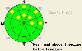
This Avalanche Advisory was published on December 20, 2008:

|
December 20, 2008 at 7:45 am |
|
Near and above treeline, avalanche danger is LOW with pockets of MODERATE danger on NW-N-NE-E aspects, 35 degrees and steeper. Below treeline, avalanche danger is LOW with pockets of MODERATE danger on NW-N-NE-E aspects, 35 degrees and steeper. |
|
|
|
Forecast Discussion:
A short lived break in the weather will occur today and tonight before the next storm system begins to affect our area sometime on Sunday. Ridgetop winds have decreased significantly overnight and remain moderate in speed out of the west southwest this morning. Air temperatures at the upper elevations are expected to warm to near freezing today, bringing some of the warmest air temperatures observed over the past week and a half.
Yesterday, very strong winds worked to redistribute existing snow on the ground and move new snow accumulation far down slope below ridgelines. Observations made on Mt. Judah (Donner Summit area) and on Fireplug (Mount Rose area) both identified shallow slab formation just below the ridgelines, becoming thicker (up to 8 to 14 inches) several hundred feet down slope. On Mt. Judah, the greatest area of instability was observed near treeline on a north aspect at 7,900'. Whumphing with shooting cracks up to 40' and stability tests indicating that fracture propagation was likely with relatively little force (ECTP-6) were all observed in this area. The snowpack failed at the interface between the old and new snow. In this location, the slab was composed of 14 inches of 4 finger hard higher density new snow which sat on top of fist hard lower density old snow.
Today, natural avalanches are unlikely, but human triggered avalanches remain possible. Several weak layers exist within the snowpack, especially near and below treeline in more wind sheltered areas. Higher density new snow on top of lower density old snow, buried surface hoar, and faceted snow crystals near the bottom of the snowpack are all existing weak layers with absence or presence varying by location. Significant avalanches will occur with failure of the snowpack on any of these weak layers.
For today's conditions, it may not be the first person on the slope who triggers an avalanche. Human triggered avalanches are expected to require larger triggers or just simply finding the right trigger point on a slope with a smaller trigger. Tracks made several feet to one side or another of an isolated rock, tree, or shallow area of the snowpack may be the difference between safe passage and a triggered avalanche.
The bottom line:
Near and above treeline, avalanche danger is LOW with pockets of MODERATE danger on NW-N-NE-E aspects, 35 degrees and steeper. Below treeline, avalanche danger is LOW with pockets of MODERATE danger on NW-N-NE-E aspects, 35 degrees and steeper.
The bottom line:
Near and above treeline, avalanche danger is LOW with pockets of MODERATE danger on NW-N-NE-E aspects, 35 degrees and steeper. Below treeline, avalanche danger is LOW with pockets of MODERATE danger on NW-N-NE-E aspects, 35 degrees and steeper.
Weather Observations from along the Sierra Crest between 8200 ft and 8800 ft:
| 0600 temperature: | 11 deg. F. |
| Max. temperature in the last 24 hours: | 17 deg. F. |
| Average wind direction during the last 24 hours: | West Southwest |
| Average wind speed during the last 24 hours: | 41 mph |
| Maximum wind gust in the last 24 hours: | 118 mph |
| New snowfall in the last 24 hours: | Trace to 3 inches |
| Total snow depth: | 33 inches |
Two-Day Mountain Weather Forecast - Produced in partnership with the Reno NWS
For 7000-8000 ft: |
|||
| Saturday: | Saturday Night: | Sunday: | |
| Weather: | Partly cloudy skies. | Mostly cloudy skies. | Cloudy with a chance of snow in the morning. Increasing snowfall in the afternoon. |
| Temperatures: | 23 to 30 deg. F. | 16 to 23 deg. F. | 25 to 32 deg. F. |
| Wind direction: | NW | NW | SW |
| Wind speed: | Around 10 mph | 5 to 10 mph | 10 to 20 mph with gusts to 30 mph in the afternoon. |
| Expected snowfall: | O in. | O in. | Trace to 4 in. |
For 8000-9000 ft: |
|||
| Saturday: | Saturday Night: | Sunday: | |
| Weather: | Partly cloudy skies. | Mostly cloudy skies. | Cloudy with a chance of snow in the morning. Increasing snowfall in the afternoon. |
| Temperatures: | 23 to 30 deg. F. | 18 to 25 deg. F. | 23 to 30 deg. F. |
| Wind direction: | NW | NW | SW |
| Wind speed: | 20 to 30 with gusts to 45 mph | 15 to 25 mph with gusts to 45 mph | 25 to 35 mph with gusts to 45 mph |
| Expected snowfall: | O in. | O in. | Trace to 4 inches in. |


