In partnership with: 
|
December 23, 2008 at 8:03 am |
|
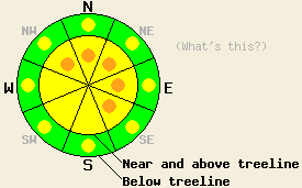
Near and above treeline the avalanche danger is MODERATE with pockets of CONSIDERABLE on NW-N-NE-E-SE slopes steeper than 35 degrees. Below treeline the avalanche danger is LOW with pockets of MODERATE on open slopes steeper than 35 degrees. |
|
|
|
Overnight 6 to 10 inches of new snow fell across the forecast area. A small ridge of high pressure moving into the area should bring some short term clearing today. Two more back to back low pressure systems should begin affecting the forecast area tonight with increasing southwest winds. These systems should be warmer and more moist than the last few storms. The forecast calls for snow levels to rise slightly on Wednesday before dropping again by Thursday. These two systems could produce 18 to 24 inches of snow above 7000' by Thursday afternoon.
Yesterday, avalanche activity occurred on steep wind loaded slopes along the Sierra Crest near and above treeline as a result of large triggers. Skiers produced small avalanches on steep test slopes in the Silver Peak area below treeline but could not cause failure on similar slopes above treeline. The test slope failure occurred on the interface between the two most recent storms. Observations in the Mount Rose area showed less avalanche activity and smaller avalanches due to less snow and wind loading. Observations indicate that a variety of weak layers and slabs exist across the forecast area.
Overnight and through today, human triggered avalanche will remain possible below treeline and will be probable near and above treeline on steep wind loaded slopes. Some natural avalanche activity may still be possible on the most heavily wind loaded slopes near and above treeline. NW-N-NE-E-SE aspects should have the most new wind loading and should be the most prone to avalanche activity today. Most avalanches should fail on the interface between the two most recent storms; however, large avalanches resulting from failure of an older weak layer are still possible today and would have serious consequences.
Near and above treeline the avalanche danger is MODERATE with pockets of CONSIDERABLE on NW-N-NE-E-SE slopes steeper than 35 degrees. Below treeline the avalanche danger is LOW with pockets of MODERATE on open slopes steeper than 35 degrees.
| 0600 temperature: | 15 deg. F. |
| Max. temperature in the last 24 hours: | 19 deg. F. |
| Average wind direction during the last 24 hours: | Southwest |
| Average wind speed during the last 24 hours: | 35-45 mph |
| Maximum wind gust in the last 24 hours: | 74 mph |
| New snowfall in the last 24 hours: | 8-10 inches |
| Total snow depth: | 50 inches |
For 7000-8000 ft: |
|||
| Tuesday: | Tuesday Night: | Wednesday: | |
| Weather: | Mostly cloudy with scattered snow showers in the morning. Isolated snow showers in the afternoon. | Cloudy with chance of snow. | Snow. |
| Temperatures: | 20-27 deg. F. | 10-17 deg. F. | 23-30 deg. F. |
| Wind direction: | West | Southwest | Southwest |
| Wind speed: | 10-15 mph with gusts to 25 mph. | 10-15 mph. | 10 to 15 mph in the morning increasing to 15 to 25 mph with gusts to 45 mph in the afternoon. |
| Expected snowfall: | up to 1 in. | up to 1 in. | 3-6 in. |
For 8000-9000 ft: |
|||
| Tuesday: | Tuesday Night: | Wednesday: | |
| Weather: | Mostly cloudy with scattered snow showers in the morning. Isolated snow showers in the afternoon. | Cloudy with chance of snow. | Snow. |
| Temperatures: | 12-19 deg. F. | 11-17 deg. F. | 20-27 deg. F. |
| Wind direction: | West | Southwest | Southwest |
| Wind speed: | 20-30 mph with gusts to 50 mph decreasing to 10-20 mph with gusts to 30 mph in the afternoon. | 15-20 mph with gusts to 40 mph. | 25-40 mph with gusts to 60 mph increasing to 40-55 mph with gusts to 90 mph in the afternoon. |
| Expected snowfall: | up to 1 in. | up to 2 in. | 4-8 in. |


This website is owned and maintained by the non-profit arm of the Sierra Avalanche Center. Some of the content is updated by the USDA avalanche forecasters including the forecasts and some observational data. The USDA is not responsible for any advertising, fund-raising events/information, or sponsorship information, or other content not related to the forecasts and the data pertaining to the forecasts.

