In partnership with: 
|
December 25, 2008 at 8:11 am |
|
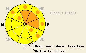
Near and above treeline on slopes steeper than 35 degrees, the avalanche danger is CONSIDERABLE on N-NE-E aspects with pockets of CONSIDERABLE on NW and SE aspects. Below treeline on open slopes steeper than 35 degrees, the avalanche danger is MODERATE with pockets of CONSIDERABLE on the NW-N-NE-E-SE aspects. Human-triggered avalanches will be probable today. Use extra caution when traveling in the backcountry. |
|
|
|
12 to 14 inches of new snow fell across the forecast area overnight. The southwest winds have averaged over 60 mph since yesterday. As this storm system passes over the forecast area today, snowfall should increase in intensity this morning before tapering to showers this evening. The forecast predicts another 8 to 16 inches of snow today. The winds should also peak this morning. A small ridge of high pressure follows this storm and should bring colder temperatures, clearer skies, and northeast winds to the forecast area tomorrow.
By midday yesterday the strong winds had transported enough snow to create small reactive wind slabs in the Mt. Judah area. A skier's weight easily broke the bond between these wind slabs and Monday night's low density snow. This failure resulted in avalanche activity on several small N-NE-E facing test slopes in the area. A snowmobile-triggered avalanche large enough to bury or injure a person was reported just west of Bear Valley without any injuries. In areas that received less wind and new snow yesterday, like Becker Peak near Echo Summit and the Mount Rose area, observations showed hardly any slab formation.
Today's primary avalanche concern will be the large wind slabs that have formed during the last 24 hours. Last night's snow was much more dense than the snow that has been falling on the forecast area. The strong winds have used this new heavy snow to form heavy wind slabs on top of the light snow that fell on Monday night. These wind slabs should continue to grow today as more snow and wind impact the forecast area. Avalanches should grow in size as the wind slabs expand. Avalanches involving these wind slabs could be large. These wind slabs will be larger and more widespread on the N-NE-E aspects. Some wind slabs should also form in cross-loaded gullies on the NW and SE aspects.
Even in areas unaffected by the wind, the new snow will be heavier than the layer below it and will create an upside-down snowpack. This stratigraphy will be the second avalanche concern today and could result in avalanches on steep, open slopes below treeline.
Today natural avalanche activity is possible and human-triggered avalanches are probable on wind-loaded NW-N-NE-E-SE aspects steeper than 35 degrees. Human-triggered avalanches are possible on any steep open slopes today. Some avalanches could still step down to the older weak layers today.
Near and above treeline on slopes steeper than 35 degrees, the avalanche danger is CONSIDERABLE on N-NE-E aspects with pockets of CONSIDERABLE on NW and SE aspects. Below treeline on open slopes steeper than 35 degrees, the avalanche danger is MODERATE with pockets of CONSIDERABLE on the NW-N-NE-E-SE aspects. Human-triggered avalanches will be probable today. Use extra caution when traveling in the backcountry.
| 0600 temperature: | 25 deg. F. |
| Max. temperature in the last 24 hours: | 27 deg. F. |
| Average wind direction during the last 24 hours: | Southwest |
| Average wind speed during the last 24 hours: | 60-70 mph |
| Maximum wind gust in the last 24 hours: | 132 mph |
| New snowfall in the last 24 hours: | 12-14 inches |
| Total snow depth: | 53-60 inches |
For 7000-8000 ft: |
|||
| Thursday: | Thursday Night: | Friday: | |
| Weather: | Snow. | Snow showers. | Partly cloudy in the morning becoming mostly cloudy in the afternoon. |
| Temperatures: | 21-27 deg. F. | 3-10 deg. F. | 15-22 deg. F. |
| Wind direction: | Southwest shifting to the west | West | West shifting to the northeast |
| Wind speed: | 25-35 mph with gusts to 65 mph decreasing to 15-25 mph with gusts to 45 mph in the afternoon. | 10-15 mph with gusts to 30 mph. | 10 mph. |
| Expected snowfall: | 8-12 in. | 2-4 in. | O in. |
For 8000-9000 ft: |
|||
| Thursday: | Thursday Night: | Friday: | |
| Weather: | Snow. | Snow showers. | Partly cloudy in the morning becoming mostly cloudy with a chance of snow showers in the afternoon. |
| Temperatures: | 13-21 deg. F. | 0-7 deg. F. | 11-18 deg. F. |
| Wind direction: | Southwest shifting to the west | West | West shifting to the northeast |
| Wind speed: | 40-60 mph with gusts to 120 mph decreasing to 30-45 mph with gusts to 85 mph in the afternoon. | 20-35 mph with gusts to 60 mph. | 20-30 mph with gusts to 50 mph decreasing to 10-15 mph with gusts to 25 mph |
| Expected snowfall: | 10-16 in. | 2-4 in. | O in. |


This website is owned and maintained by the non-profit arm of the Sierra Avalanche Center. Some of the content is updated by the USDA avalanche forecasters including the forecasts and some observational data. The USDA is not responsible for any advertising, fund-raising events/information, or sponsorship information, or other content not related to the forecasts and the data pertaining to the forecasts.

