In partnership with: 
|
December 30, 2008 at 7:54 am |
|
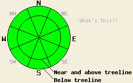
The avalanche danger is LOW for all elevations and aspects. Human triggered avalanches are unlikely but not impossible today. Isolated areas of instability may exist. |
|
|
|
A high pressure ridge should bring warmer temperatures, less wind, and sunny skies to the forecast area today. The winds started to decrease overnight and have averaged about 20 mph since 6pm yesterday. By 6 am this morning the remote sensors already showed temperatures in the low 30's above 7000'.
Yesterday, observations in the Mount Rose area and on Jake's Peak continued to show a variety of snow surface conditions. On open N-NE-E aspects stiff wind affected surface snow and some hard slabs exist. Areas protected from the NE winds on those same aspects continue to hold soft, unconsolidated surface snow above 7800'. On the southerly aspects sun-crusts have formed up to at least 9000'. Snowpit tests show bonds between and within layers in the snowpack gaining strength in both of these areas. These tests also indicate continued variability in strength and distribution of the older weak layers in the snowpack. No avalanche activity was reported yesterday.
Even though dangerous avalanche activity is unlikely today, two concerns warrant extra caution because of their consequences. First, small point releases and pinwheels that may occur on southerly aspects due to daytime warming. These small, isolated instabilities should not pose much of a threat to backcountry travelers. They could be large enough to knock a person off balance. Being knocked off balance while standing in a dangerous spot like the edge of a cliff could result in serious consequences.
The second concern today is isolated hard wind slabs near and above treeline on wind affected slopes that are 37 degrees or steeper. These slabs should be hard to trigger and are unlikely to produce avalanches today. However, there is a small chance that the right trigger in the right spot could result in a very isolated human-triggered slab avalanche. These unlikely avalanches would be a surprise to the person who triggers them due to otherwise widespread stable conditions. Use good travel habits to minimize these risks.
The avalanche danger is LOW for all elevations and aspects. Human triggered avalanches are unlikely but not impossible today. Isolated areas of instability may exist.
| 0600 temperature: | 32 deg. F. |
| Max. temperature in the last 24 hours: | 32 deg. F. |
| Average wind direction during the last 24 hours: | Southwest |
| Average wind speed during the last 24 hours: | 25-35 mph |
| Maximum wind gust in the last 24 hours: | 68 mph |
| New snowfall in the last 24 hours: | O inches |
| Total snow depth: | 59-67 inches |
For 7000-8000 ft: |
|||
| Tuesday: | Tuesday Night: | Wednesday: | |
| Weather: | Sunny | Clear | Partly cloudy |
| Temperatures: | 40-46 deg. F. | 28-34 deg. F. | 37-42 deg. F. |
| Wind direction: | West shifting to the southwest | Southwest | Southwest |
| Wind speed: | 10 mph | 10-15 mph with gusts to 25 mph | 10-15 mph |
| Expected snowfall: | O in. | O in. | O in. |
For 8000-9000 ft: |
|||
| Tuesday: | Tuesday Night: | Wednesday: | |
| Weather: | Sunny | Clear | Partly cloudy |
| Temperatures: | 36-44 deg. F. | 27-32 deg. F. | 33-38 deg. F. |
| Wind direction: | West shifting to the southwest | Southwest | West |
| Wind speed: | 10-15 mph increasing to 15-20 mph with gusts to 45 mph | 15-25 mph with ridgetop gusts to 65 mph | 10-20 mph with gusts to 40 mph |
| Expected snowfall: | O in. | O in. | O in. |


This website is owned and maintained by the non-profit arm of the Sierra Avalanche Center. Some of the content is updated by the USDA avalanche forecasters including the forecasts and some observational data. The USDA is not responsible for any advertising, fund-raising events/information, or sponsorship information, or other content not related to the forecasts and the data pertaining to the forecasts.

