In partnership with: 
|
December 31, 2008 at 8:00 am |
|
The avalanche danger is LOW for all elevations and aspects. Human triggered avalanches are unlikely but not impossible today. Isolated areas of instability may exist. This advisory will be updated on January 2nd, 2009 by 7:00 am. |
|
|
|
A low pressure system in the Pacific Northwest should cause increasing cloud cover over the forecast area through Thursday. This cloud cover should keep temperatures cooler over the next 24 hours as well. The forecast calls for a second stronger system to move into the Pacific Northwest overnight on Thursday. The cold front associated with this system should reach the Central Sierra by Friday evening and should bring even cooler temperatures. This second storm system will also bring a 60% chance of snow to the forecast area during the day on Friday with 4 to 10 inches of accumulation possible. Check the Thursday's NWS backcountry forecast for updated snowfall amounts.
Yesterday, observations in the Mount Rose area and on Hidden Peak continued to show variable snow surface conditions with stiff wind affected surface snow on open N-NE-E aspects and sun-crusts on the southerly aspects. Soft, unconsolidated surface snow remains in areas protected from the NE winds on northerly aspects above 7500'. Observers reported surface hoar in the Mount Rose area and near-surface facets in the Hidden peak area on some of these protected slopes. If sun, wind, or warmth does not destroy these fragile crystals before Friday's snow, they could become failure layers for avalanche activity. Snowpit tests from both of these areas show bonds between and within layers in the snowpack gaining strength. These tests also indicate that the older weak layers of facets still exist near the bottom of the snowpack. Observers reported some small surface sluffs on southerly sun exposed aspects in the Mount Rose area.
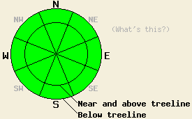
Dangerous avalanche activity is unlikely today. However, isolated hard wind slabs near and above treeline on wind affected slopes that are 37 degrees or steeper still warrant extra caution because of their consequences. These slabs should be hard to trigger and are unlikely to produce avalanches today. However, there is a small chance that the right trigger in the right spot could result in a very isolated human-triggered slab avalanche. These unlikely avalanches could be large and would be a surprise to the person who triggers them due to otherwise widespread stable conditions. Use good travel habits to minimize risk.
Surface instabilities due to daytime warming should be unlikely today due to the increased cloud cover and cooler temperatures. If the clouds do not materialize, small point releases and pinwheels could form again today.
The avalanche danger is LOW for all elevations and aspects. Human triggered avalanches are unlikely but not impossible today. Isolated areas of instability may exist. This advisory will be updated on January 2nd, 2009 by 7:00 am.
| 0600 temperature: | 31 deg. F. |
| Max. temperature in the last 24 hours: | 37 deg. F. |
| Average wind direction during the last 24 hours: | West southwest |
| Average wind speed during the last 24 hours: | 20-25 mph |
| Maximum wind gust in the last 24 hours: | 39 mph |
| New snowfall in the last 24 hours: | O inches |
| Total snow depth: | 56-65 inches |
For 7000-8000 ft: |
|||
| Wednesday: | Wednesday Night: | Thursday: | |
| Weather: | Partly cloudy this morning becoming mostly cloudy this afternoon | Mostly cloudy | Mostly cloudy |
| Temperatures: | 34-41 deg. F. | 20-27 deg. F. | 36-43 deg. F. |
| Wind direction: | West shifting to the south this afternoon | West | Southwest |
| Wind speed: | 10-15 mph | 10-15 mph with gusts to 25 mph | 10-15 mph with gusts to 25 mph |
| Expected snowfall: | O in. | O in. | O in. |
For 8000-9000 ft: |
|||
| Wednesday: | Wednesday Night: | Thursday: | |
| Weather: | Partly cloudy this morning becoming mostly cloudy this afternoon | Mostly cloudy | Mostly cloudy |
| Temperatures: | 32-39 deg. F. | 21-28 deg. F. | 32-39 deg. F. |
| Wind direction: | West shifting to the south this afternoon | West | West |
| Wind speed: | 10-15 mph with gusts to 30 mph | 10-15 mph with gusts to 35 mph increasing to 15-25 mph with gusts to 45 mph after midnight | 10-20 mph with gusts to 30 mph |
| Expected snowfall: | O in. | O in. | O in. |


This website is owned and maintained by the non-profit arm of the Sierra Avalanche Center. Some of the content is updated by the USDA avalanche forecasters including the forecasts and some observational data. The USDA is not responsible for any advertising, fund-raising events/information, or sponsorship information, or other content not related to the forecasts and the data pertaining to the forecasts.

