In partnership with: 
|
January 3, 2009 at 7:45 am |
|
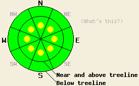
Near and above treeline, avalanche danger is LOW with pockets of MODERATE danger on all aspects, 37 degrees and steeper. Below treeline, avalanche danger is LOW. |
|
|
|
The weather system that affected the forecast area yesterday has moved off to the east, leaving a mix of clear skies and lingering clouds over some of the peaks this morning. Storm totals are 4 to 8 inches along the Sierra Crest and 3 to 5 inches in the Mount Rose area. Strong ridgetop winds that occurred yesterday have become light overnight and are shifting to the northeast and east this morning. Moderate speed east winds are expected to develop during the day today. Air temperatures have fallen around 20 deg F over the past 24 hours, with mountain top air temperatures in the low teens this morning.
Yesterday's weather system started warm and became progressively colder. Observations from Silver Peak and Deep Creek (both areas North of Squaw Peak) indicated rain had fallen up to near 8,500' before precipitation type switched to snow. On Silver Peak, significant wind transport of snow was observed near and above treeline with wind loading observed on N-NE-E aspects. A snowpit was dug at 8,100' on a 30 degree NNE aspect. Stability tests revealed moderate force shears occurring on the bottom of the newly formed rain crust, with fracture propagation potential indicated as unlikely. On Deep Creek Peak, a snowpit was dug at 7251' on a 38 degree N aspect below treeline. Stability tests revealed easy and moderate force shears within the new snow. Ski cuts produced some minor sluffing below treeline on steeper slopes and slope convexities. Needle crystals and graupel were noted within the new snow in both areas.
Today, human triggered slab avalanches will remain possible on steep slopes near and above treeline. Slabs that formed yesterday will remain in recently wind load areas, mainly on NW-N-NE-E-SE aspects. Developing east winds today are expected to redistribute snow onto SE-S-SW-W-NW aspects, creating fresh slabs in these areas. Any avalanche activity that occurs today is expected to be human triggered, size D2 or smaller. Below treeline, minor human triggered sluff activity remains possible today in open areas 37 degrees and steeper with new snow moving on yesterday's rain crust.
Near and above treeline, avalanche danger is LOW with pockets of MODERATE danger on all aspects, 37 degrees and steeper. Below treeline, avalanche danger is LOW.
| 0600 temperature: | 11 deg. F. |
| Max. temperature in the last 24 hours: | 29 deg. F. |
| Average wind direction during the last 24 hours: | West southwest, shifting to east. |
| Average wind speed during the last 24 hours: | 48 mph |
| Maximum wind gust in the last 24 hours: | 101 mph |
| New snowfall in the last 24 hours: | 3 to 8 inches |
| Total snow depth: | 57 to 67 inches |
For 7000-8000 ft: |
|||
| Saturday: | Saturday Night: | Sunday: | |
| Weather: | Partly cloudy skies. | Mostly cloudy skies. | Sunny in the morning, then increasing high clouds. |
| Temperatures: | 22 to 27 deg. F. | 8 to 13 deg. F. | 24 to 29 deg. F. |
| Wind direction: | NE | E | E in the morning, becoming variable. |
| Wind speed: | Increasing to 10 to 15 mph with gusts to 25 mph. | Up to 10 mph. | Up to 10 mph, becoming light in the afternoon. |
| Expected snowfall: | O in. | O in. | O in. |
For 8000-9000 ft: |
|||
| Saturday: | Saturday Night: | Sunday: | |
| Weather: | Partly cloudy skies. | Mostly cloudy skies. | Sunny in the morning, then increasing high clouds. |
| Temperatures: | 17 to 22 deg. F. | 7 to 12 deg. F. | 21 to 26 deg. F. |
| Wind direction: | NE | SE | Variable, mostly SE |
| Wind speed: | 10 to 20 mph with gusts to 30 mph. | Up to 10 mph. | Up to 10 mph. |
| Expected snowfall: | O in. | O in. | O in. |


This website is owned and maintained by the non-profit arm of the Sierra Avalanche Center. Some of the content is updated by the USDA avalanche forecasters including the forecasts and some observational data. The USDA is not responsible for any advertising, fund-raising events/information, or sponsorship information, or other content not related to the forecasts and the data pertaining to the forecasts.

