In partnership with: 
|
January 10, 2009 at 7:41 am |
|
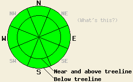
Avalanche danger is LOW for all elevations and aspects. Normal caution is advised. |
|
|
|
High pressure continues to build over the forecast area. Warm air temperatures are expected over the next several days. Ridgetop winds are forecast to remain from the east and moderate in speed today. An air temperature inversion is in place over the forecast area this morning. Above the 7,000' level, air temperatures have risen overnight and are near or above freezing at this time.
Observations around the forecast area, most recently from the Luther Pass and Mount Rose areas continue to indicate a generally stable snowpack. On northerly aspects, stability tests still reveal moderate to hard force shears within the snowpack in areas where the January 2nd rain crust exists and/or there is a basal layer of faceted snow. Despite these findings, natural and human triggered avalanches remain unlikely at this time. This is due to the strong cohesion of stable snow above these layers. We will continue to watch these layers for possible future avalanche concerns. Snow surface conditions consist mainly of melt-freeze snow and supportable wind affected snow. At higher elevations, a few isolated pockets of unconsolidated surface snow exist below treeline in wind protected areas.
Some melting of surface snow will occur today in sun exposed areas. Melting is also expected at lower elevations in shaded areas. Cool east winds may limit melting in some wind exposed areas. Any wet snow instability that may occur is expected to be very small. This should not pose a significant threat to backcountry travelers. As always, use good travel habits to minimize risk.
| 0600 temperature: | 32 deg. F. |
| Max. temperature in the last 24 hours: | 32 deg. F. |
| Average wind direction during the last 24 hours: | East |
| Average wind speed during the last 24 hours: | 38 mph |
| Maximum wind gust in the last 24 hours: | 69 mph |
| New snowfall in the last 24 hours: | O inches |
| Total snow depth: | 62 inches |
For 7000-8000 ft: |
|||
| Saturday: | Saturday Night: | Sunday: | |
| Weather: | Sunny skies. | Partly cloudy in the evening, becoming clear. | Sunny skies. |
| Temperatures: | 39 to 46 deg. F. | 19 to 29 deg. F. | 49 to 55 deg. F. |
| Wind direction: | E shifting to N in the afternoon. | NE | E |
| Wind speed: | 10 to 20 mph with gusts to 35 mph in the morning. | 10 to 15 mph with gusts to 35 mph. | Around 10 mph. |
| Expected snowfall: | O in. | O in. | O in. |
For 8000-9000 ft: |
|||
| Saturday: | Saturday Night: | Sunday: | |
| Weather: | Sunny skies. | Partly cloudy in the evening, becoming clear. | Sunny skies. |
| Temperatures: | 36 to 44 deg. F. | 26 to 36 deg. F. | 41 to 50 deg. F. |
| Wind direction: | E shifting to N in the afternoon. | NE | N |
| Wind speed: | 25 to 35 mph with gusts to 65 mph. | 25 to 40 mph with gusts to 65 mph. | 25 to 35 mph with gusts to 60 mph. |
| Expected snowfall: | O in. | O in. | O in. |


This website is owned and maintained by the non-profit arm of the Sierra Avalanche Center. Some of the content is updated by the USDA avalanche forecasters including the forecasts and some observational data. The USDA is not responsible for any advertising, fund-raising events/information, or sponsorship information, or other content not related to the forecasts and the data pertaining to the forecasts.

