This Avalanche Advisory was published on January 26, 2009:

|
January 26, 2009 at 7:59 am |
|
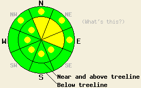
Near and above treeline, areas of MODERATE avalanche danger exist on all aspects, 37 degrees and steeper. Below treeline, avalanche danger is LOW with pockets of MODERATE danger above 7,500' on NW-N-NE-E aspect open areas, 37 degrees and steeper. |
|
|
|
Forecast Discussion:
One more weather system is expected to slide from north to south through the forecast area today. The weather forecast calls for mostly cloudy to cloudy skies, snow showers, moderate east winds, and air temperatures in the teens at the upper elevations. Another 3 to 7 inches of new snow has accumulated over the past 24 hours. This brings storm totals to 12 to 24 inches above 8,500'. The greatest overall accumulations have been observed along the Sierra Crest south of Hwy 50.
Yesterday, instability within the storm snow was observed in a variety of locations. On Hidden Peak (West Shore Lake Tahoe), easy skier triggering of soft slab avalanches with crowns up to 14 inches deep occurred at 9,200' on lightly wind loaded NE aspect test slopes, 37 to 49 degrees steep. Stability tests performed in the immediate area indicated that fracture propagation from relatively little force was likely. The failure layer was identified as a mix of needle and plate snow crystals. On Mt. Judah (Donner Summit area), intentional human triggered cornice collapse produced avalanches within the storm snow with crowns 12 to 16 inches deep at 8,200' on NE to E aspect slopes around 40 degrees steep. These avalanches propagated up to 65' wide and ran several hundred vertical feet, close to full path at times. In the Bear Valley/Ebbetts Pass area, the Mountain Adventure Seminars Guide Service reported no natural avalanches and no human triggered avalanche activity on terrain less than 35 degrees in slope angle.
Today, human triggered avalanches will remain possible. Natural avalanches are unlikely. Instability similar to that observed yesterday is expected to linger in steep near and above treeline areas on N-NE-E aspects. Additionally, ridgetop winds that shifted from SW to NW to NE yesterday and overnight will redistribute snow onto SE-S-SW-W-NW aspects above treeline. This will create new areas of snowpack instability with fresh slabs forming in lee areas. Some sluffing of surface snow is expected in below treeline areas above the 7,500' elevation band, mainly on steep NW-N-NE-E aspects.
The bottom line:
Near and above treeline, areas of MODERATE avalanche danger exist on all aspects, 37 degrees and steeper. Below treeline, avalanche danger is LOW with pockets of MODERATE danger above 7,500' on NW-N-NE-E aspect open areas, 37 degrees and steeper.
Weather Observations from along the Sierra Crest between 8200 ft and 8800 ft:
| 0600 temperature: | 10 deg. F. |
| Max. temperature in the last 24 hours: | 22 deg. F. |
| Average wind direction during the last 24 hours: | Southwest shifting to east. |
| Average wind speed during the last 24 hours: | 20 mph |
| Maximum wind gust in the last 24 hours: | 42 mph |
| New snowfall in the last 24 hours: | 3 to 7 inches |
| Total snow depth: | 78 inches |
Two-Day Mountain Weather Forecast - Produced in partnership with the Reno NWS
For 7000-8000 ft: |
|||
| Monday: | Monday Night: | Tuesday: | |
| Weather: | Mostly cloudy to cloudy skies. Isolated snow showers in the morning, becoming scattered in the afternoon. | Partly cloudy skies with isolated snow showers in the evening. | Sunny skies. |
| Temperatures: | 17 to 24 deg. F. | 1 to 8 deg. F. | 26 to 33 deg. F. |
| Wind direction: | NE to E | E | E |
| Wind speed: | Around 10 mph. | 10 to 15 mph with gusts to 25 mph. | 10 to 15 mph with gusts to 25 mph. |
| Expected snowfall: | Trace in. | Trace in. | O in. |
For 8000-9000 ft: |
|||
| Monday: | Monday Night: | Tuesday: | |
| Weather: | Mostly cloudy to cloudy skies. Isolated snow showers in the morning, becoming scattered in the afternoon. | Mostly cloudy skies with isolated snow showers in the evening. Partly cloudy skies after midnight. | Sunny skies. |
| Temperatures: | 15 to 21 deg. F. | 0 to 7 deg. F. | 21 to 28 deg. F. |
| Wind direction: | NE to E | E | E |
| Wind speed: | 15 to 20 mph with gusts to 30 mph. | 20 to 30 mph with gusts to 55 mph. | 20 to 30 mph with gusts to 60 mph. |
| Expected snowfall: | Trace to 1 in. | Trace in. | O in. |


