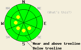
This Avalanche Advisory was published on January 27, 2009:

|
January 27, 2009 at 7:47 am |
|
Near and above treeline, avalanche danger is LOW with pockets of MODERATE danger on SE-S-SW-W-NW aspects, 37 degrees and steeper. Below treeline, avalanche danger is LOW. |
|
|
|
Forecast Discussion:
New snowfall amounts of a trace to 1 inch accumulated in most areas from the weak weather system that passed through the forecast area yesterday. Up to 3 inches accumulated in the Ebbetts Pass area. Skies have cleared overnight, allowing for significant cooling and relatively cold air temperatures this morning at all elevations. High pressure is building over the forecast area. Air temperatures are expected to warm into the mid to upper 20s today above 7,000'. Clear skies this morning are expected to become partly cloudy as the day progresses. Ridgetop winds remain from east this morning, but have increased to moderate to strong in speed overnight.
Yesterday, observations made on Carpenter Ridge (Independence Lake area) and on Silver Peak (North of Squaw Peak) both indicated significant strengthening within the recent storm snow. A very difficult to skier trigger soft slab was noted by test slope failure on Carpenter Ridge at 8,600' on a wind loaded 40 degree N aspect just above treeline. No other evidence of current snowpack instability was observed in either area. By late yesterday afternoon, east winds were observed transporting snow to the west side of Donner Ridge (Donner Summit area) at a rate of around 0.25 inch per hour. With an increase in east winds overnight, more redistribution of new snow is expected to have occurred.
Today, wind scouring and continued bonding within the recent storm snow are expected to have ended the instability that was observed over the past few days on N-NE-E aspects. Some roller ball activity may occur today in areas below 7,000'. This low elevation snow surface warming is not expected to present a significant hazard to backcountry travelers. East winds will continue to transport snow to lee areas. Small pockets of instability are expected mainly in steep above treeline areas due to wind loading on SE-S-SW-W-NW aspects. Human triggered avalanches remain possible today in the most heavily wind loaded areas. Natural avalanches remain unlikely.
The bottom line:
Near and above treeline, avalanche danger is LOW with pockets of MODERATE danger on SE-S-SW-W-NW aspects, 37 degrees and steeper. Below treeline, avalanche danger is LOW.
Weather Observations from along the Sierra Crest between 8200 ft and 8800 ft:
| 0600 temperature: | 10 deg. F. |
| Max. temperature in the last 24 hours: | 21 to 26 deg. F. |
| Average wind direction during the last 24 hours: | East |
| Average wind speed during the last 24 hours: | 41 mph |
| Maximum wind gust in the last 24 hours: | 71 mph |
| New snowfall in the last 24 hours: | Trace to 1 inches |
| Total snow depth: | 75 inches |
Two-Day Mountain Weather Forecast - Produced in partnership with the Reno NWS
For 7000-8000 ft: |
|||
| Tuesday: | Tuesday Night: | Wednesday: | |
| Weather: | Sunny skies in the morning becoming partly cloudy. | Partly cloudy skies in the evening, becoming clear. | Sunny skies. |
| Temperatures: | 27 to 34 deg. F. | 13 to 19 deg. F. | 32 to 39 deg. F. |
| Wind direction: | E | NE | NE |
| Wind speed: | 10 to 15 mph with gusts to 25 mph. | Around 10 mph. | 10 to 15 mph with gusts to 25 mph. |
| Expected snowfall: | O in. | O in. | O in. |
For 8000-9000 ft: |
|||
| Tuesday: | Tuesday Night: | Wednesday: | |
| Weather: | Sunny skies in the morning becoming partly cloudy. | Partly cloudy skies in the evening, becoming clear. | Sunny skies. |
| Temperatures: | 22 to 29 deg. F. | 10 to 17 deg. F. | 29 to 35 deg. F. |
| Wind direction: | E | NE | NE |
| Wind speed: | 25 to 35 mph with gusts to 60 mph. | 20 to 30 mph with gusts to 55 mph. | 25 to 35 mph with gusts to 60 mph. |
| Expected snowfall: | O in. | O in. | O in. |


