In partnership with: 
|
January 28, 2009 at 7:43 am |
|
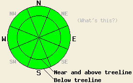
Avalanche danger is LOW for all elevations and aspects. Normal caution is advised. |
|
|
|
High pressure continues to build into the forecast area. Sunny skies and above freezing air temperatures are expected today in nearly all locations. Ridgetop winds shifted to the north and then to the west for a few hours overnight as a weak weather disturbance passed through extreme northern CA/NV. Ridgetop winds have shifted back to the northeast this morning and are light to moderate in speed.
Yesterday, east to northeast ridgetop winds were observed to move snow over ridges in near and above treeline areas. Observations made on Relay Peak (Mount Rose area) revealed very small pockets of instability in wind loaded areas, mainly on SW and W aspects. Isolated areas of snowpack collapse and shooting cracks were observed along the ridgetop, resulting from the passage of a skier. No human triggered avalanches were created on wind loaded test slopes as the newly formed slabs were quite small and refused to move, despite the other signs of instability. Sunny skies and air temperatures just below freezing caused significant settlement of new snow. On SE aspects that have been cross loaded by both the SW storm winds and the recent NE winds some skier triggered roller balls and pinwheels occurred yesterday all the way up to 9,800'. No other evidence of warming instability was observed.
Today, expect minimal instability as ridgetop winds that shifted overnight will have worked to scour snow from recently wind loaded areas and reduce the size of any pockets of instability. Minimal snow remains available for transport by northeast winds today so new slab formation will be minimal to nonexistent. With a day of intermediate warming having occurred yesterday between the end of the storm on Monday and above freezing air temperatures today, avalanche activity caused by snow surface warming is not expected. Widespread roller balls and pinwheels caused by snow falling from trees and rocks should be the limit of surface warming instability. Natural avalanches are unlikely, human triggered avalanches are unlikely but not impossible. Use good travel habits to minimize risk.
| 0600 temperature: | 25 deg. F. |
| Max. temperature in the last 24 hours: | 31 deg. F. |
| Average wind direction during the last 24 hours: | NE backing to W overnight, then shifting to NE. |
| Average wind speed during the last 24 hours: | 24 mph |
| Maximum wind gust in the last 24 hours: | 47 mph |
| New snowfall in the last 24 hours: | O inches |
| Total snow depth: | 74 inches |
For 7000-8000 ft: |
|||
| Wednesday: | Wednesday Night: | Thursday: | |
| Weather: | Sunny skies. | Clear skies. | Sunny skies. |
| Temperatures: | 34 to 41 deg. F. | 17 to 23 deg. F. | 37 to 44 deg. F. |
| Wind direction: | NE | NE | E |
| Wind speed: | 10 to 15 mph with gusts to 25 mph. | Around 10 mph. | 10 to 15 mph. |
| Expected snowfall: | O in. | O in. | O in. |
For 8000-9000 ft: |
|||
| Wednesday: | Wednesday Night: | Thursday: | |
| Weather: | Sunny skies. | Clear skies. | Sunny skies. |
| Temperatures: | 31 to 37 deg. F. | 18 to 25 deg. F. | 37 to 44 deg. F. |
| Wind direction: | NE | NE | E |
| Wind speed: | 25 to 35 mph with gusts to 60 mph. | 25 to 35 mph with gusts to 55 mph. | 15 to 25 mph with gusts to 35 mph. |
| Expected snowfall: | O in. | O in. | O in. |


This website is owned and maintained by the non-profit arm of the Sierra Avalanche Center. Some of the content is updated by the USDA avalanche forecasters including the forecasts and some observational data. The USDA is not responsible for any advertising, fund-raising events/information, or sponsorship information, or other content not related to the forecasts and the data pertaining to the forecasts.

