In partnership with: 
|
February 5, 2009 at 8:00 am |
|
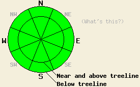
The avalanche danger is LOW for all elevations and aspects. The avalanche danger will increase over the next 24 hours. Use normal caution when traveling in the backcountry. |
|
|
|
A low pressure system moving into California should bring 1-2 inches of new snow to the forecast area by this evening. The forecast calls for an additional 3-8 inches of snow by the end of the day on Friday. The south winds started to increase this morning ahead of this low and should remain strong through the storm. This system should also bring much cooler temperatures to the forecast area causing snow level to quickly drop to about 5500' today. A second, colder system should follow this low pressure.
This week observations and snowpit data throughout the forecast area show a strong, stable snowpack that should handle moderate new snow loads well. Yesterday observations from Carson Pass and Castle Peak showed similar strength. All observations continue to show a mix of melt/freeze conditions on the southerly aspects, unconsolidated surface snow and near surface facets on the northerly aspects sheltered from the wind and sun, and crusts from wind and sun on exposed northerly aspects. All of these types of snow could form potential weak layers or sliding surfaces depending on how well the new snow bonds to them. Sun and warm temperatures seem to have destroyed most of the surface hoar observed earlier in the week.
The 1-2 inches of snow forecast for today should not be enough to cause widespread avalanche activity even if it does not bond well to the current snow surfaces. However, as more snow and wind impact the forecast area, wind slabs will become the primary avalanche concern. These wind slabs should start to form today on the NW-N-NE aspects due to loading from the southerly winds. Human-triggerable shooting cracks and small, shallow wind slabs may occur on steep, wind-loaded slopes near and above treeline today. While these instabilities should remain too small to pose much threat to backcountry travelers, they will indicate the strength of the bond between the new snow and the old snow surfaces. They will also indicate where larger more dangerous wind slabs might form later in this storm.
The avalanche danger is LOW for all elevations and aspects. The avalanche danger will increase over the next 24 hours. Use normal caution when traveling in the backcountry.
| 0600 temperature: | 30 deg. F. |
| Max. temperature in the last 24 hours: | 44 deg. F. |
| Average wind direction during the last 24 hours: | South |
| Average wind speed during the last 24 hours: | 15 mph |
| Maximum wind gust in the last 24 hours: | 47 mph |
| New snowfall in the last 24 hours: | O inches |
| Total snow depth: | 66 inches |
For 7000-8000 ft: |
|||
| Thursday: | Thursday Night: | Friday: | |
| Weather: | Scattered snow showers this morning becoming widespread by this afternoon | Snow showers in the evening becoming scattered and decreasing after midnight | Scattered snow showers in the morning becoming widespread by the afternoon |
| Temperatures: | 30-37 deg. F. | 23-29 deg. F. | 25-32 deg. F. |
| Wind direction: | South | Southwest | South |
| Wind speed: | 10-15 mph with gusts to 30 mph | 15-25 mph with gusts to 40 mph | 10-15 mph with gusts to 25 mph |
| Expected snowfall: | 1-2 in. | up to 3 in. | 3-5 in. |
For 8000-9000 ft: |
|||
| Thursday: | Thursday Night: | Friday: | |
| Weather: | Scattered snow showers this morning becoming widespread by this afternoon | Snow showers in the evening becoming scattered and decreasing after midnight | Scattered snow showers in the morning becoming widespread by the afternoon |
| Temperatures: | 24-31 deg. F. | 20-27 deg. F. | 21-28 deg. F. |
| Wind direction: | South | Southwest | South |
| Wind speed: | 25-40 mph with gusts to 65 mph | 25- 40 mph with gusts to 70 mph decreasing to 60 mph after midnight | 20-30 mph with gusts to 50 mph |
| Expected snowfall: | 1-2 in. | up to 3 in. | 4-6 in. |


This website is owned and maintained by the non-profit arm of the Sierra Avalanche Center. Some of the content is updated by the USDA avalanche forecasters including the forecasts and some observational data. The USDA is not responsible for any advertising, fund-raising events/information, or sponsorship information, or other content not related to the forecasts and the data pertaining to the forecasts.

