In partnership with: 
|
February 13, 2009 at 8:00 am |
|
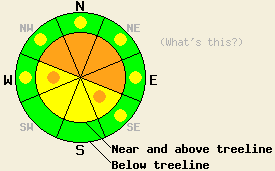
Near and above treeline, avalanche danger is CONSIDERABLE on NW-N-NE-E aspects, 35 degrees and steeper. Below treeline, avalanche danger is LOW with pockets of MODERATE danger developing in open areas, 37 degrees and steeper. |
|
|
|
Another storm system moved into to the forecast area early this morning. A 4 to 5 hour period of high intensity snowfall is expected to begin around 7 or 8 am and continue until mid day. Continued snow showers and cooling air temperatures are forecast to occur this afternoon. Air temperatures above 7,000' are in the teens this morning and are expected to remain fairly static until this afternoon. Ridgetop winds are out of the south to southwest this morning. Winds increased in speed during the overnight hours and are strong this morning.
Yesterday, observations made on Mt. Tallac (Desolation Wilderness area) and on Becker Peak (Echo Summit area) both indicated a fairly stable snowpack. In both areas, minimal slab formation was observed in wind exposed areas. Skier triggered sluffs were common on steep terrain features at all elevations. Tender cornices were reported on Becker Peak. On Mt. Tallac, some faceted snow crystals were observed on N-NE-E aspects below 8,700' at the base of the recent storm snow layers. Some very minimal skier triggered cracking was observed on this layer with stability tests yielding rough shears. Some degree of concern exists for snowpack failure at this layer interface as new snow loading continues above it. Overnight, significant wind transport and wind loading over ridges was reported from the Alpine Meadows Ski Area. Similar wind transport and wind loading is expected to have occurred in the backcountry.
Today, the combination of wind loading that occurred last night and the high intensity snowfall today will allow for unstable slabs up to several feet deep in the most heavily wind loaded areas. Areas of wind loading that occurred overnight and are continuing this morning will hold slabs that are sensitive to human triggering. Natural avalanches are possible, mainly near and above treeline on steep NW-N-NE-E aspects. During the period of high intensity snowfall that is expected this morning, the rapid addition of new snow will further increase the size and instability of slabs that formed overnight in lee areas.
Near and above treeline, avalanche danger is CONSIDERABLE on NW-N-NE-E aspects, 35 degrees and steeper. Below treeline, avalanche danger is LOW with pockets of MODERATE danger developing in open areas, 37 degrees and steeper.
| 0600 temperature: | 13 deg. F. |
| Max. temperature in the last 24 hours: | 19 deg. F. |
| Average wind direction during the last 24 hours: | Southwest shifting to south. |
| Average wind speed during the last 24 hours: | 37 mph |
| Maximum wind gust in the last 24 hours: | 79 mph |
| New snowfall in the last 24 hours: | Trace inches |
| Total snow depth: | 88 inches |
For 7000-8000 ft: |
|||
| Friday: | Friday Night: | Saturday: | |
| Weather: | Cloudy skies with snow. | Cloudy skies with snow showers. | Cloudy skies with numerous snow showers. |
| Temperatures: | 23 to 28 deg. F. | 15 to 20 deg. F. | 22 to 27 deg. F. |
| Wind direction: | S shifting to SW | SW | S |
| Wind speed: | 15 to 20 mph with gusts to 35 mph. | 10 to 15 mph with gusts to 25 mph. Increasing to 15 to 25 mph with gusts to 35 mph after midnight. | 10 to 15 mph with gusts to 25 mph. |
| Expected snowfall: | 4 to 9 in. | 2 to 5 in. | Up to 4 in. |
For 8000-9000 ft: |
|||
| Friday: | Friday Night: | Saturday: | |
| Weather: | Cloudy skies with snow. | Cloudy skies with snow showers. | Cloudy skies with numerous snow showers. |
| Temperatures: | 13 to 23 deg. F. | 5 to 11 deg. F. | 15 to 22 deg. F. |
| Wind direction: | S shifting to SW | SW | SW |
| Wind speed: | 30 to 40 mph with gusts to 70 mph. Decreasing to 20 to 30 mph with gusts to 50 mph in the afternoon. | 10 to 20 mph with gusts to 30 mph. Increasing to 20 to 30 mph with gusts to 45 mph after midnight. | 15 to 20 mph with gusts to 35 mph. |
| Expected snowfall: | 6 to 12 in. | 3 to 6 in. | 1 to 4 in. |


This website is owned and maintained by the non-profit arm of the Sierra Avalanche Center. Some of the content is updated by the USDA avalanche forecasters including the forecasts and some observational data. The USDA is not responsible for any advertising, fund-raising events/information, or sponsorship information, or other content not related to the forecasts and the data pertaining to the forecasts.

