In partnership with: 
|
February 17, 2009 at 8:00 am |
|
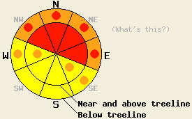
Large natural and human-triggered avalanches are likely. Near and above treeline the avalanche danger is HIGH on NW-N-NE-E aspects steeper than 35 degrees. Pockets of HIGH danger should also exist on slopes steeper than 35 degrees on the NW-N-NE-E aspects below treeline. Avalanche activity will be less likely on the windward SE-S-SW aspects. Backcountry travel in or around avalanche terrain is not recommended. |
|
|
|
Snow should continue along the Sierra Crest this morning. As the center of the low pressure system moves inland today the snow showers should increase and become more widespread. The forecast calls for another 8-16 inches of snow along the crest and 5-9 inches on the east side of Lake Tahoe. The southwest winds have decreased some, but they should remain strong enough to transport snow through tonight. By tomorrow a high pressure ridge should start to build over the forecast area causing snow to end and winds to decrease.
Since February 8th 62-87 inches of snow has fallen along the Sierra Crest. East of the lake in the Carson Range 30-40 inches has fallen. This new snow accumulated on top of a variety of hard crusts leftover from the warm weather and rain in January. Observations from across the forecast area show that weak, faceted snow has formed around these crusts. Layer bonding tests indicate that these facets are not strong enough to support the weight of the snowpack above them in many areas. Some large avalanches have occurred due to failure of this layer with minimal triggers.
Yesterday, observations on Mt. Judah also showed weakness in the most recent snow. 6-12 inch wind slabs on small, wind-loaded test slopes failed in response to a skier's weight. Shooting cracks up to 40 ft also occurred on wind loaded terrain. Large, fragile cornices that failed up to 10 ft away from their edges and fractured for 150 ft along the cornice with a single kick had also formed on wind-exposed ridges.
Wind slabs will continue to be the primary avalanche concern today. The new snow and wind will add snow to the wind slabs that already exist making them larger and more dangerous. They should be most widespread near and above treeline on wind-loaded NW-N-NE-E aspects. Reactive wind slabs could also grow below treeline on open, wind-loaded slopes. Today, they could fail naturally due to the new snow and wind loading; they could fail due to natural cornice collapses; and they could easily fail due to human triggers. These slabs could be large and could step down to the older weak layers below February's snow.
The second avalanche concern today will be large, deep slabs that fail on the weak facets near the January crusts. Loading by new snow, wind, or people could be enough to release some of these deep slabs. Avalanches that occur due to failure at this layer could have crowns of more than 8 feet and could propagate across large areas. This weak layer exists both above and below treeline. These avalanches will be most likely on all steep N-NE-E aspects.
Avalanche activity should be less likely in the Carson Range east of Lake Tahoe due to the smaller amounts of snow received in those mountains.
Large natural and human-triggered avalanches are likely. Near and above treeline the avalanche danger is HIGH on NW-N-NE-E aspects steeper than 35 degrees. Pockets of HIGH danger should also exist on slopes steeper than 35 degrees on the NW-N-NE-E aspects below treeline. Avalanche activity will be less likely on the windward SE-S-SW aspects. Backcountry travel in or around avalanche terrain is not recommended.
| 0600 temperature: | 16 deg. F. |
| Max. temperature in the last 24 hours: | 21 deg. F. |
| Average wind direction during the last 24 hours: | Southwest |
| Average wind speed during the last 24 hours: | 36 mph |
| Maximum wind gust in the last 24 hours: | 74 mph |
| New snowfall in the last 24 hours: | 9-13 inches |
| Total snow depth: | 94-117 inches |
For 7000-8000 ft: |
|||
| Tuesday: | Tuesday Night: | Wednesday: | |
| Weather: | Snow with the most intense snow between 10 am and 4 pm | Snow showers decreasing and becoming isolated after midnight | Partly cloudy in the morning becoming mostly cloudy in the afternoon |
| Temperatures: | 21-28 deg. F. | 10-16 deg. F. | 26-34 deg. F. |
| Wind direction: | Southwest | Southwest | South shifting to the southeast |
| Wind speed: | 10-20 mph with gusts to 35 mph | 10-15 mph with gusts to 30 mph | 10 mph |
| Expected snowfall: | 8-16 in. | up to 3 in. | O in. |
For 8000-9000 ft: |
|||
| Tuesday: | Tuesday Night: | Wednesday: | |
| Weather: | Snow with the most intense snow between 10 am and 4 pm | Snow showers decreasing and becoming isolated after midnight | Partly cloudy in the morning becoming mostly cloudy in the afternoon |
| Temperatures: | 16-23 deg. F. | 6-13 deg. F. | 22-29 deg. F. |
| Wind direction: | Southwest | Southwest | South shifting to the southeast |
| Wind speed: | 20-40 mph with gusts to 60 mph | 10-20 mph with gusts to 35 mph | 10 mph |
| Expected snowfall: | 8-16 in. | up to 3 in. | O in. |


This website is owned and maintained by the non-profit arm of the Sierra Avalanche Center. Some of the content is updated by the USDA avalanche forecasters including the forecasts and some observational data. The USDA is not responsible for any advertising, fund-raising events/information, or sponsorship information, or other content not related to the forecasts and the data pertaining to the forecasts.

