In partnership with: 
|
February 19, 2009 at 8:01 am |
|
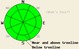
Avalanche danger is LOW for all elevations and aspects. Human triggered avalanches are unlikely but not impossible today. An unlikely human triggered avalanche may be large with severe consequences possible. Use normal caution and good travel habits while in the backcountry. |
|
|
|
High pressure is forecast to remain in place over the forecast area until later this weekend. Expect sunny skies, light winds, and warm air temperatures for the next few days. Air temperatures in the teens and 20s this morning are forecast to rise to near and above freezing in most locations today. Light ridgetop winds over the past 24 hours are expected to continue today.
Yesterday, observations made on Hidden Peak (West Shore Tahoe area), Mt. Judah (Donner Summit area), and on Tamarack Peak (Mount Rose area) all indicate settlement and stabilization of the recent storm snow. Overall the snowpack has good stability at this time. With the strengthening within the recent storm snow, the layer interface with the greatest relative weakness as shifted to the base of the recent storm snow. Along the Sierra Crest, this is a layer of faceted snow crystals just above the January 22-23 rain crust. In the Carson Range on the east side of Lake Tahoe, this is a layer of faceted snow just above and below the uppermost crust in the snowpack. These layers are found 3 to 7 feet deep in the snowpack, on all aspects, generally below 9,500' along the Sierra Crest and at all elevations in the Carson Range. Stability tests have indicated that this layer is also gaining strength, but that fracture propagation remains possible to likely on this layer interface.
No new natural or human triggered avalanche activity has been reported to occur within the forecast area since February 17, despite yesterday's media craze over the report of an old avalanche outside the boundary of the Mt. Rose Ski Area. From February 14 to 17, the vast majority of avalanches occurred within the recent storm snow. Only two reports of avalanches confirmed to have failed on the above mentioned crust / facet layers were received. Both events were human triggered. One event occurred on February 14 on Carpenter Peak (Independence Lake area) and the other event occurred outside the boundary of the Mt. Rose Ski Area on February 17.
Today, human triggered avalanches are unlikely but not impossible. Triggering an avalanche will be very difficult today. Any avalanche activity today is expected to be very, very isolated. However, in the unlikely event of a human triggered avalanche, the size of the avalanche could be quited large with a crown of 3 to 7 feet and severe consequences possible. Warming air temperatures today are expected to cause roller ball activity, but no significant warming instability of surface snow.
Avalanche danger is LOW for all elevations and aspects. Human triggered avalanches are unlikely but not impossible today. An unlikely human triggered avalanche may be large with severe consequences possible. Use normal caution and good travel habits while in the backcountry.
| 0600 temperature: | 20 to 29 deg. F. |
| Max. temperature in the last 24 hours: | 31 deg. F. |
| Average wind direction during the last 24 hours: | Southwest shifting to south. |
| Average wind speed during the last 24 hours: | 15 mph |
| Maximum wind gust in the last 24 hours: | 28 mph |
| New snowfall in the last 24 hours: | O inches |
| Total snow depth: | 115 inches |
For 7000-8000 ft: |
|||
| Thursday: | Thursday Night: | Friday: | |
| Weather: | Sunny skies. | Clear skies. | Partly cloudy skies. |
| Temperatures: | 37 to 45 deg. F. | 14 to 24 deg. F. | 37 to 45 deg. F. |
| Wind direction: | S | SW | SW |
| Wind speed: | Light winds. | Light winds. | Light winds. |
| Expected snowfall: | O in. | O in. | O in. |
For 8000-9000 ft: |
|||
| Thursday: | Thursday Night: | Friday: | |
| Weather: | Sunny skies. | Clear skies. | Partly cloudy skies. |
| Temperatures: | 30 to 40 deg. F. | 20 to 30 deg. F. | 30 to 40 deg. F. |
| Wind direction: | S | SW | SW |
| Wind speed: | 10 to 15 mph with gusts to 25 mph. | 10 to 15 mph with gusts to 25 mph in the evening. | Light winds. |
| Expected snowfall: | O in. | O in. | O in. |


This website is owned and maintained by the non-profit arm of the Sierra Avalanche Center. Some of the content is updated by the USDA avalanche forecasters including the forecasts and some observational data. The USDA is not responsible for any advertising, fund-raising events/information, or sponsorship information, or other content not related to the forecasts and the data pertaining to the forecasts.

