In partnership with: 
|
February 21, 2009 at 7:59 am |
|
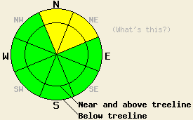
Avalanche danger is MODERATE both above and below treeline on N-NE aspects 35 degrees and steeper due to persistent deep slab instability. Elsewhere, avalanche danger is LOW. Possible consequences from human triggered avalanches remain high. Use good travel habits to minimize risk. |
|
|
|
Cloud cover will continue to increase over the forecast area today as a major storm system approaches the area. Rain and snow is expected to begin tonight and continue into Monday. Air temperatures are near freezing this morning above 7,000'. Air temperatures are expected to warm into the mid 30s to low 40s today in most locations. South to southwest ridgetop winds are light this morning, but are forecast to increase to moderate in speed as the day progresses.
Deep slab instability continues to persist within the forecast area. Previous thinking that only very large triggers were sufficient to cause human triggered avalanches was shattered yesterday. Two avalanches were triggered yesterday by the weight of a single person on a slope. A third avalanche was reported to have occurred secondary to another large human triggered cornice collapse. Each avalanche was large enough to bury a person.
Recent observations from around the forecast area indicate that the storm snow from February 6 - 17 has gained considerable strength. This has moved the relatively weakest layer within the snowpack down to the base of the storm snow where a layer of faceted snow crystals sits on top of the January 22-23 rain crust. This is the source of the continuing deep slab instability with four human triggered avalanches with crowns 3 to 6 feet reported in the past two days. Human triggered avalanche activity has been focused along the Sierra Crest on N-NE aspects between 7,400' and 8,700' on slopes 35 degrees and steeper. Each of the four events have occurred in complex terrain and/or heavily wind loaded areas.
Three human triggered avalanches were reported yesterday. One was triggered by a person walking on the edge of a ridge in the upper portion of Cabin Creek near Tinker's Knob (Between Sugar Bowl and Squaw Valley) at approximately 8,100' on a heavily wind loaded N aspect steeper than 35 degrees (photos). The second reported avalanche was triggered by an ascending skier in the Cascade Creek drainage (Desolation Wilderness area) in rocky, treed, complex terrain at 7,600' on a N aspect with varying slope angle of 36 to 40 degrees. Whumpfing and shooting cracks were observed by the same party in this area and by another backcountry traveler nearby on the Maggies Peaks. The third reported avalanche occurred on Castle Peak (Donner Summit area) and was human triggered by unintentional cornice collapse. Few details are available with the avalanche occurring on a N or NE aspect likely near 8,500' to 8,700' of unknown slope angle, but probably steeper than 35 degrees based on knowledge of that terrain. The triggering individual was reported to have fallen over the edge with the collapsing cornice but escaped injury and was not caught in the ensuing avalanche. A video of the February 19 intentionally human triggered avalanche which occurred in the same area has been made available (click here to view).
Today, despite the plethora of ski, snowboard, and snowmobile tracks that are visible on steep northerly aspects throughout the forecast area, human triggered avalanches with crowns 3 to 7 feet deep remain possible. Deep slab avalanches are notoriously hard to forecast for on both a regional scale and on an individual slope scale. Individuals should exercise great caution, gathering detailed information before choosing to travel on steep N-NE aspects in previously wind loaded or complex terrain. Very large cornices remain prone to collapse and should be approached with great caution. Surface hoar as been observed in a variety of areas over the past few days. Much of it is expected to be destroyed prior to the onset of snowfall. If you see surface hoar that is still persisting this afternoon, please let us know its location, elevation, distribution, and amount of area covered.
Avalanche danger is MODERATE both above and below treeline on N-NE aspects 35 degrees and steeper due to persistent deep slab instability. Elsewhere, avalanche danger is LOW. Possible consequences from human triggered avalanches remain high. Use good travel habits to minimize risk.
| 0600 temperature: | 30 deg. F. |
| Max. temperature in the last 24 hours: | 38 deg. F. |
| Average wind direction during the last 24 hours: | South to southwest |
| Average wind speed during the last 24 hours: | 14 mph |
| Maximum wind gust in the last 24 hours: | 29 mph |
| New snowfall in the last 24 hours: | O inches |
| Total snow depth: | 110 inches |
For 7000-8000 ft: |
|||
| Saturday: | Saturday Night: | Sunday: | |
| Weather: | Partly cloudy skies in the morning, then mostly cloudy in the afternoon. | Chance of rain and snow in the evening, then rain and snow likely after midnight. Snow level 7,000ft to 7,500ft. | Rain and snow. Snow level 7,500ft to 8,000ft. |
| Temperatures: | 39 to 45 deg. F. | Around 32 deg. F. | 35 to 40 deg. F. |
| Wind direction: | SW shifting to S | S | S |
| Wind speed: | Increasing to 10 to 20 mph by mid day. | 15 to 25 mph with gusts to 40 mph. | 15 to 25 mph with gusts to 40 mph. |
| Expected snowfall: | O in. | Up to 2 in. | Up to 3 in. |
For 8000-9000 ft: |
|||
| Saturday: | Saturday Night: | Sunday: | |
| Weather: | Partly cloudy skies in the morning, then mostly cloudy in the afternoon. | Chance of snow in the evening, then snow likely after midnight. | Snow in the morning, then snow and rain in the afternoon. |
| Temperatures: | 35 to 40 deg. F. | 21 to 28 deg. F. | 30 to 35 deg. F. |
| Wind direction: | SW shifting to S | S | S |
| Wind speed: | 10 to 20 mph with gusts to 30 mph, increasing to 20 to 30 mph with gusts to 50 mph in the afternoon. | 20 to 35 mph with gusts to 60 mph | 20 to 35 mph with gusts to 65 mph. |
| Expected snowfall: | O in. | Up to 2 in. | 3 to 7 in. |


This website is owned and maintained by the non-profit arm of the Sierra Avalanche Center. Some of the content is updated by the USDA avalanche forecasters including the forecasts and some observational data. The USDA is not responsible for any advertising, fund-raising events/information, or sponsorship information, or other content not related to the forecasts and the data pertaining to the forecasts.

