In partnership with: 
|
March 2, 2009 at 8:00 am |
|
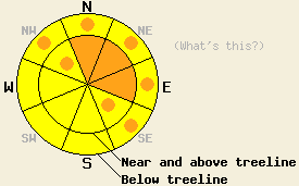
On slopes steeper than 35 degrees near and above treeline the avalanche danger is CONSIDERABLE for N-NE-E aspects with pockets of CONSIDERABLE on the NW and SE aspects. Below treeline the avalanche danger is MODERATE with pockets of CONSIDERABLE on open NW-N-NE-E-SE aspects 35 degrees and steeper. |
|
|
|
The deep low pressure off the west coast should push another colder wave of precipitation through the forecast area today. The snow levels should drop to between 6000'-6500' this morning and fall to 4000'-4500' tonight. Another wave of precipitation should follow on Tuesday / Tuesday night. Above 7000' the forecast calls for snowfall totals measured in feet by Wednesday morning. Strong southwest winds should continue through the storm.
Snow levels stayed between 6500' and 7500' yesterday. Above 7500' the Sierra Crest picked up 12-15 inches and the Carson Range east of the Lake received 8-10 inches of new, heavy (14-18% density) snow in the last 24 hours. Observations in the Mt. Judah area yesterday morning and in the Mt. Rose area showed significant wind transport, rapid cornice formation, and rapid wind slab growth on the N-NE aspects. By midday some shooting cracks and small test slope failures occurred due to the weight of a skier in the Mt. Judah area on N-NE aspects between 7600' and 8200'. Below 7600' precipitation was a mix of rain and snow. Some ski width wet snow sluffs resulted from ski cuts on lower elevation test slopes.
Today avalanche concern number one will be wind slabs formed by the strong southwest winds and the new snow. These new wind slabs will form on top of a mix of soft snow, crusts, and hard slabs. The new wind slabs may have difficulty bonding to these old snow surfaces. The changing temperatures, shifting winds, and other variable storm conditions will also create weaknesses in the new snow that could serve as failure layers for these wind slabs. As snow and wind continue today these wind slabs will increase in size and distribution. Failure of these wind slabs due to a skier, boarder, snowmobiler, or cornice collapse will be likely today. Natural avalanches involving these wind slabs will also be possible. Open, wind-loaded, N-NE-E aspects will hold the largest and most fragile wind slabs today. Cross-loading could create some triggerable wind slabs on NW and SE aspects as well. The consistently strong southwest winds could form these wind slabs in unexpected places. Use clues like blowing snow, drifts, cornices, ripples, and other signs of wind transport to determine where the most wind loading has occurred.
The second avalanche concern today will continue to be deep slabs due to failure of the crust / facet layer at the base of the Feb. snow. Variability in the strength of this layer will make it harder to predict what will cause it to fail and where that failure might occur. Northerly aspects between 7400'-8700' that have steep, open, unsupported (for example: a cliff at the bottom of a steep slope), and rocky terrain will hold the best potential for triggering this persistent weak layer. Avalanches due to failure of this layer could be triggered by a person from the right trigger point or avalanches that start due to failure of the new wind slabs could step down to this layer. Failure of this layer would result in large dangerous avalanches.
On slopes steeper than 35 degrees near and above treeline the avalanche danger is CONSIDERABLE for N-NE-E aspects with pockets of CONSIDERABLE on the NW and SE aspects. Below treeline the avalanche danger is MODERATE with pockets of CONSIDERABLE on open NW-N-NE-E-SE aspects 35 degrees and steeper.
| 0600 temperature: | 30-32 deg. F. |
| Max. temperature in the last 24 hours: | 35-39 deg. F. |
| Average wind direction during the last 24 hours: | Southwest |
| Average wind speed during the last 24 hours: | 50 mph |
| Maximum wind gust in the last 24 hours: | 93 mph |
| New snowfall in the last 24 hours: | 12 inches |
| Total snow depth: | 134 inches |
For 7000-8000 ft: |
|||
| Monday: | Monday Night: | Tuesday: | |
| Weather: | Snow showers with some isolated thunder storms this afternoon | Snow | Snow |
| Temperatures: | 37-43 deg. F. | 16-23 deg. F. | 23-30 deg. F. |
| Wind direction: | South | Southwest | Southwest |
| Wind speed: | 20-35 mph with gusts to 50 mph | 20-30 mph with gusts to 45 mph | 20-30 mph with gusts to 45 mph |
| Expected snowfall: | 6-12 in. | 8-16 in. | 8-16 in. |
For 8000-9000 ft: |
|||
| Monday: | Monday Night: | Tuesday: | |
| Weather: | Snow showers with some isolated thunder storms this afternoon | Snow | Snow |
| Temperatures: | 30-36 deg. F. | 12-19 deg. F. | 22-28 deg. F. |
| Wind direction: | South | Southwest | Southwest |
| Wind speed: | 45-60 mph with gusts to 100 mph | 35-50 mph with gusts to 100 mph | 35-50 mph with gusts to 100 mph |
| Expected snowfall: | 8-14 in. | 10-16 in. | 10-16 in. |


This website is owned and maintained by the non-profit arm of the Sierra Avalanche Center. Some of the content is updated by the USDA avalanche forecasters including the forecasts and some observational data. The USDA is not responsible for any advertising, fund-raising events/information, or sponsorship information, or other content not related to the forecasts and the data pertaining to the forecasts.

