In partnership with: 
|
March 6, 2009 at 8:00 am |
|
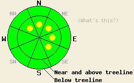
Near and above treeline on open, wind-loaded slopes 35 degrees and steeper, pockets of MODERATE avalanche danger still exist on NW-N-NE-E-SE aspects. Below treeline, avalanche danger is LOW. |
|
|
|
A dry, cold front should cause continued winds, some light snow, and some cloud cover across the forecast area today. The wind should begin to decrease and shift to the west today and to the northwest by this evening. A small high pressure system cause the winds to shift to the north and to decrease even more tomorrow. This high pressure should also bring sunny skies and warmer temperatures to the area.
Observations from Silver Peak, Mt. Judah, and Negro Canyon as well as remote sensors across the forecast area show significant settlement and consolidation within the March storm snow. The weaknesses formed during the storm continue to gain strength and to bond with the layers around them. Yesterday, layer bonding tests also showed good cohesion between the rain crust at the base of the new snow and the snow above and below it. Some wind transport and new wind loading occurred yesterday near the ridgetops. Below treeline the winds remained light and did not move much snow. A breakable crust formed on sun-exposed aspects up to at least 8000' yesterday. The shaded northerly aspects still held cold, soft snow. Observers reported some sluffing on the steep northerly aspects.
Today wind slabs will be the primary avalanche concern. The strong ridgetop winds will continue to move snow from the windward aspects to the leeward slopes near and above treeline adding to the wind slabs that formed during the storm. As the winds decrease, they will move less snow and load the leeward slopes more slowly. This slower loading will allow the snowpack to adjust more quickly to the new loading. Human triggering of these wind slabs should still be possible today. However, this instability should be more isolated and limited to upper elevation starting zones near ridgetops where the most wind loading will occur.
Near and above treeline on open, wind-loaded slopes 35 degrees and steeper, pockets of MODERATE avalanche danger still exist on NW-N-NE-E-SE aspects. Below treeline, avalanche danger is LOW.
| 0600 temperature: | 16 deg. F. |
| Max. temperature in the last 24 hours: | 26-30 deg. F. |
| Average wind direction during the last 24 hours: | West - Southwest |
| Average wind speed during the last 24 hours: | 39 mph |
| Maximum wind gust in the last 24 hours: | 83 mph |
| New snowfall in the last 24 hours: | Trace inches |
| Total snow depth: | 161 inches |
For 7000-8000 ft: |
|||
| Friday: | Friday Night: | Saturday: | |
| Weather: | Mostly cloudy with scattered snow showers in the morning. Showers should decrease in the afternoon. | Partly cloudy becoming clear after midnight | Sunny |
| Temperatures: | 27-33 deg. F. | 6-13 deg. F. | 35-41 deg. F. |
| Wind direction: | West | Northwest | North |
| Wind speed: | 10-15 mph with gusts to 30 mph | 10-15 mph with gusts to 30 mph | 10 mph |
| Expected snowfall: | trace in. | O in. | O in. |
For 8000-9000 ft: |
|||
| Friday: | Friday Night: | Saturday: | |
| Weather: | Mostly cloudy with scattered snow showers in the morning. Showers should decrease in the afternoon. | Partly cloudy with some isolated snow showers in the evening becoming clear after midnight | Sunny |
| Temperatures: | 18-25 deg. F. | 8-14 deg. F. | 29-35 deg. F. |
| Wind direction: | West | Northwest | North |
| Wind speed: | 20-30 mph with gusts to 50 mph | 20-30 mph with gusts to 50 mph | 15-25 mph with gusts to 35 mph decreasing to 10-15 mph in the afternoon |
| Expected snowfall: | trace in. | O in. | O in. |


This website is owned and maintained by the non-profit arm of the Sierra Avalanche Center. Some of the content is updated by the USDA avalanche forecasters including the forecasts and some observational data. The USDA is not responsible for any advertising, fund-raising events/information, or sponsorship information, or other content not related to the forecasts and the data pertaining to the forecasts.

