In partnership with: 
|
March 8, 2009 at 6:42 am |
|
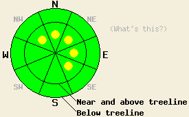
Near and above treeline on open, wind-loaded slopes 37 degrees and steeper, isolated pockets of MODERATE avalanche danger could develop on NW-N-NE-E-SE aspects. Below treeline, avalanche danger is LOW. |
|
|
|
The winds started to shift to the west - southwest and increase overnight as a strong cold front approaches the area. Cloud cover should also start to increase today. By tonight this cold front should cause temperatures to drop, and it could bring a dusting of new snow to the forecast area. Tomorrow, temperatures should remain cool and the winds should start to shift to the northwest.
Yesterday, observations from Maggie's Peak and Silver Peak showed a mostly stable snowpack. The winds did not transport much snow, and avalanche activity remained limited. Some small, point-release avalanches occurred near cliffs and rocks on steep SE facing slopes between 7500'-8500' on Jake's Peak and in the Eagle Creek drainage. Strong winds, cooler temperatures, and cloud cover should limit this warming instability today.
Over the last few days observations from the Mt. Rose area, the Donner Summit area, Silver Peak, Maggie's Peak, Ralston Peak, and the West Shore all showed a strengthening snowpack. The March snow has formed bonds within itself, and it has bonded well with the rain crust that formed on March 1st. The mild, sunny days have left sun crusts and melt / freeze crusts on most SE-S-SW-W aspects up to 8800'. The NW and E aspects hold a mix of soft snow and wind / sun crusts. Soft, powdery snow still exists on most of the sheltered N-NE aspects.
Today, the strong west and southwest winds should start to move snow from the S-SW-W aspects back over to the N-NE-E aspects. Some cross-loading could also occur on the NW and SE aspects. The crusts that have formed over the last few days should help limit this wind transport and hold some of the snow in place. The winds could move enough snow to form some small, isolated wind slabs on leeward slopes near and above treeline. Human triggering of these isolated wind slabs could be possible on steep, wind-loaded slopes. As the winds continue and increase this evening, these slabs should grow larger and more widespread. These wind slabs will be the primary avalanche concern today.
Near and above treeline on open, wind-loaded slopes 37 degrees and steeper, isolated pockets of MODERATE avalanche danger could develop on NW-N-NE-E-SE aspects. Below treeline, avalanche danger is LOW.
| 0600 temperature: | 23 deg. F. |
| Max. temperature in the last 24 hours: | 33 deg. F. |
| Average wind direction during the last 24 hours: | East shifting to the west after 6 pm last night |
| Average wind speed during the last 24 hours: | 21 mph |
| Maximum wind gust in the last 24 hours: | 48 mph |
| New snowfall in the last 24 hours: | O inches |
| Total snow depth: | 153 inches |
For 7000-8000 ft: |
|||
| Sunday: | Sunday Night: | Monday: | |
| Weather: | Partly cloudy in the morning becoming mostly cloudy with an isolated chance of snow showers this afternoon. | Mostly cloudy with scattered snow showers | Mostly cloudy with scattered snow showers in the morning. Snow showers should decrease in the afternoon. |
| Temperatures: | 35-41 deg. F. | 9-16 deg. F. | 22-28 deg. F. |
| Wind direction: | West shifting to the southwest | Southwest | Northwest |
| Wind speed: | 10-15 mph with gusts to 25 mph increasing to 20-30 mph with gusts to 65 mph in the afternoon | 30-45 mph with gusts to 75 mph | 20-30 mph with gusts to 65 mph decreasing to 40 mph in the afternoon |
| Expected snowfall: | trace in. | up to 2 in. | trace in. |
For 8000-9000 ft: |
|||
| Sunday: | Sunday Night: | Monday: | |
| Weather: | Partly cloudy in the morning becoming mostly cloudy with an isolated chance of snow showers this afternoon. | Mostly cloudy with scattered snow showers | Mostly cloudy with scattered snow showers in the morning. Snow showers should decrease in the afternoon. |
| Temperatures: | 29-35 deg. F. | 8-14 deg. F. | 17-23 deg. F. |
| Wind direction: | West shifting to the southwest | Southwest | Northwest |
| Wind speed: | 20-30 mph with gusts to 45 mph increasing to 30-50 mph with gusts to 105 mph this afternoon | 40-60 mph with gusts to 105 mph | 30-50 mph with gusts to 85 mph decreasing to 25-35 mph with gusts to 60 mph in the afternoon |
| Expected snowfall: | trace in. | up to 2 in. | trace in. |


This website is owned and maintained by the non-profit arm of the Sierra Avalanche Center. Some of the content is updated by the USDA avalanche forecasters including the forecasts and some observational data. The USDA is not responsible for any advertising, fund-raising events/information, or sponsorship information, or other content not related to the forecasts and the data pertaining to the forecasts.

