In partnership with: 
|
March 9, 2009 at 6:59 am |
|
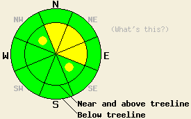
Near and above treeline, avalanche danger is MODERATE on N-NE-E aspects, 35 degrees and steeper. Pockets of MODERATE danger exist on NW and SE aspects, 35 degrees and steeper. Below treeline, avalanche danger is LOW. |
|
|
|
A cold front is passing through the forecast area this morning. SW winds have steadily increased to hurricane force speeds over the past 24 hours. A band of high intensity snowfall is expected to occur this morning, mainly north of the Lake Tahoe Basin. Local accumulations up to 3 inches are possible. As the day progresses, ridgetop winds are expected to shift from SW to NW. This will keep air temperatures cooler today with maximum daytime temperatures in the teens to mid 20s.
Yesterday in the Donner Summit and Mount Rose areas, significant blowing snow was observed over ridge features in near treeline and above treeline areas. This created wind loading and hard slab formation in lee areas, mainly on N-NE-E aspects. A remotely skier triggered avalanche occurred at 3 pm on the far NE slope of Alpine Walk Peak (Far NE Mount Rose area, N 39.3930, W 119.8986 W) near treeline at 8,100 on a NE aspect, with a 35 degree slope angle. When the skier was descending from the ridge, attempting to ski cut a wind loaded area, the avalanche occurred 30 feet below the skier within a stand of trees on a convex terrain feature. The crown measured approximately 75 feet wide and 2 to 3 feet deep. The debris ran 500' down slope. The bed surface was reported as a crust with the exact failure layer unknown. The reporting party observed that prior to the avalanche release, the slab felt and sounded "hollow" under a skier. This is a classic sign of an existing wind slab composed of old wind transported snow. Other observations made on Mt. Judah indicated significant blowing snow, wind loading and small avalanches 2 to 3 days old near and above treeline on steep N-NE aspects. Observations made below treeline on Rose Knob Peak revealed quality unconsolidated stable snow below treeline on NE aspects.
Today, human triggered avalanches large enough to bury a person remain possible in near treeline and above treeline areas on steep NW-N-NE-E-SE aspects. A mix of wind slabs and higher density hard slabs exist in many areas due to the recent and ongoing wind transport of snow. Hurricane force winds overnight and this morning will have moved any available snow to lee areas, increasing the size of slabs that were already growing in size yesterday afternoon. Exercise caution around this type of instability as signs such as cracking, collapsing, and test slope failure may not be readily apparent in areas around unstable slopes. Use good travel habits and choose slopes without secondary exposures such as terrain traps, cliffs, or dense trees below the slope to further minimize risk.
Near and above treeline, avalanche danger is MODERATE on N-NE-E aspects, 35 degrees and steeper. Pockets of MODERATE danger exist on NW and SE aspects, 35 degrees and steeper. Below treeline, avalanche danger is LOW.
| 0600 temperature: | 15 deg. F. |
| Max. temperature in the last 24 hours: | 29 deg. F. |
| Average wind direction during the last 24 hours: | Southwest |
| Average wind speed during the last 24 hours: | 59 mph |
| Maximum wind gust in the last 24 hours: | 105 mph |
| New snowfall in the last 24 hours: | Trace inches |
| Total snow depth: | 152 inches |
For 7000-8000 ft: |
|||
| Monday: | Monday Night: | Tuesday: | |
| Weather: | Mostly cloudy skies with scattered snow showers. Local areas of high intensity snowfall this morning. | Partly cloudy skies in the evening becoming clear. | Sunny skies in the morning, becoming partly cloudy. |
| Temperatures: | 20 to 26 deg. F. | 4 to 12 deg. F. | 27 to 34 deg. F. |
| Wind direction: | SW shifting to NW | W | E |
| Wind speed: | 20 to 30 mph with gusts to 60 mph. Gusts decreasing to 40 mph in the afternoon. | 10 to 20 mph with gusts to 35 mph in the evening, becoming light. | Up to 10 mph in the morning, becoming light. |
| Expected snowfall: | Up to 3 in. | O in. | O in. |
For 8000-9000 ft: |
|||
| Monday: | Monday Night: | Tuesday: | |
| Weather: | Mostly cloudy skies with scattered snow showers. Local areas of high intensity snowfall this morning. | Partly cloudy skies in the evening becoming clear. | Sunny skies in the morning, becoming partly cloudy. |
| Temperatures: | 12 to 20 deg. F. | 3 to 9 deg. F. | 22 to 29 deg. F. |
| Wind direction: | SW shifting to NW | NW | NE |
| Wind speed: | 30 to 50 mph with gusts to 70 mph. Winds decreasing to 25 to 35 mph with gusts to 60 mph in the afternoon. | 15 to 25 mph with gusts to 50 mph. Winds decreasing to around 10 mph with gusts to 25 mph after midnight. | 10 to 15 mph with gusts to 40 mph in the morning. |
| Expected snowfall: | Up to 3 in. | O in. | O in. |


This website is owned and maintained by the non-profit arm of the Sierra Avalanche Center. Some of the content is updated by the USDA avalanche forecasters including the forecasts and some observational data. The USDA is not responsible for any advertising, fund-raising events/information, or sponsorship information, or other content not related to the forecasts and the data pertaining to the forecasts.

