In partnership with: 
|
March 12, 2009 at 6:59 am |
|
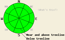
Avalanche danger is LOW for all elevations and aspects. Even though avalanche activity will remain unlikely today, very isolated human-triggered, hard-slab avalanches are not impossible above treeline. Normal caution is advised. |
|
|
|
Spring-like weather should prevail as a high-pressure ridge builds over the forecast area. The forecast calls for light to moderate east winds, sunny skies, and gradually warming temperatures over the next 24 hours. The winds should start to shift back to the southwest and west tomorrow as a low-pressure system moves through the Pacific Northwest.
The mild, calm weather has allowed continued settlement and consolidation in the snowpack. Yesterday, observations on Lincoln Ridge near Yuba Pass showed soft, powdery snow on northerly aspects protected from the sun and wind. Surfaces formed by sun and warmth like melt-freeze snow, breakable crusts, and supportable crusts existed in almost any open areas where the sun had hit the snow surface near and below treeline. These crusts and melt-freeze conditions were most widespread on the W-SW-S-SE aspects. Above treeline the intense SW winds during the last storm left hard wind slabs sitting on top of the snow pack on N-NE and some E aspects. These winds also scoured the SW-W-NW aspects leaving hard, wind-scoured surfaces. Layer bonding tests on Lincoln Ridge showed that the bonds between these wind slabs and the snow below them have gained some strength. In most areas these bonds are strong enough to hold the slab in place. Some isolated areas where these bonds remain slightly weaker still exist. Below this surface slab tests show a strong snowpack. Observations from across the forecast area this week have shown similar conditions.
Today, avalanche activity will remain unlikely across the forecast area. However, 2 minor concerns still exist. First, some small, wet-snow instabilities like point releases, pin-wheels, or roller-balls could form on the most sun exposed SE-S-SW slopes. The gradual warming and strong overnight refreeze should prevent large wet-snow instabilities from forming today.
Second a human triggered hard slab avalanche above treeline on a steep N-NE aspect is not impossible today. This unlikely but not impossible instability could still lurk on some very isolated, wind-loaded slope where the hard wind slab has not fully bonded to the snow below it. Any open areas above treeline that sound hollow, look wind loaded, or have a hard slab sitting on top of softer snow warrant extra caution today. Use good travel habits to minimize risks.
Avalanche danger is LOW for all elevations and aspects. Even though avalanche activity will remain unlikely today, very isolated human-triggered, hard-slab avalanches are not impossible above treeline. Normal caution is advised.
| 0600 temperature: | 21 deg. F. |
| Max. temperature in the last 24 hours: | 37 deg. F. |
| Average wind direction during the last 24 hours: | West shifting to the east after 8 pm yesterday |
| Average wind speed during the last 24 hours: | 15-25 mph |
| Maximum wind gust in the last 24 hours: | 38 mph |
| New snowfall in the last 24 hours: | O inches |
| Total snow depth: | 147 inches |
For 7000-8000 ft: |
|||
| Thursday: | Thursday Night: | Friday: | |
| Weather: | Sunny | Clear | Sunny |
| Temperatures: | 34-41 deg. F. | 16-23 deg. F. | 37-44 deg. F. |
| Wind direction: | East | East | Southwest shifting to the west |
| Wind speed: | 10 mph | 10 mph | 10 mph |
| Expected snowfall: | O in. | O in. | O in. |
For 8000-9000 ft: |
|||
| Thursday: | Thursday Night: | Friday: | |
| Weather: | Sunny | Clear | Sunny |
| Temperatures: | 30-37 deg. F. | 19-26 deg. F. | 32-39 deg. F. |
| Wind direction: | East | East | Southwest shifting to the west |
| Wind speed: | 10-15 mph with gusts to 25 mph | 10-15 mph with gusts to 25 mph | 10-15 mph |
| Expected snowfall: | O in. | O in. | O in. |


This website is owned and maintained by the non-profit arm of the Sierra Avalanche Center. Some of the content is updated by the USDA avalanche forecasters including the forecasts and some observational data. The USDA is not responsible for any advertising, fund-raising events/information, or sponsorship information, or other content not related to the forecasts and the data pertaining to the forecasts.

