In partnership with: 
|
March 16, 2009 at 6:52 am |
|
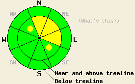
Along the Sierra Crest north of Hwy 50, avalanche danger is MODERATE near and above treeline on N-NE-E aspects, 35 degrees and steeper. Pockets of MODERATE danger exist on similar terrain on NW and SE aspects. For all other areas, avalanche danger remains LOW. |
|
|
|
A weather system continues to bring snow and rain to the northwest portion of the forecast area. Along the Sierra Crest north of Hwy 50, 2 to 3 inches of new snow has fallen with snow level around 7,100' this morning. Other portions of the forecast area further to the south and/or further to the east have received minimal precipitation, with 0 to a trace inches of new snow reported in the past 24 hours. Air temperatures are in the upper 20s to mid 30s this morning in nearly all locations. Ridgetop winds remain strong out of the southwest and are forecast to continue through tonight.
Yesterday, observations made on Yuba Pass and on Mt. Lola (Independence Lake area) showed that precipitation was confined mainly to the west side and along the Sierra Crest with little to no precipitation more than 5 to 10 miles east of the Sierra Crest. Stable snowpack conditions remained through yesterday, before precipitation intensity increased during the overnight hours.
Today, areas of snowpack instability will exist along the Sierra Crest north of Hwy 50. A few inches of new snow from last night combined with up to 4 inches of additional snowfall today will allow for the possibility of human triggered avalanches near and above treeline. This will occur above 7,000' in wind loaded areas, mainly on steep N-NE-E aspects. Some smaller pockets of unstable snow may exist in similar terrain on cross loaded NW and SE aspects due to continued strong SW winds. Any avalanche activity that occurs today will be fairly shallow and limited to the new snow. Below 7,000', the snowpack is in good condition to handle modest rainfall so rain on snow instability is not expected to occur today. For areas to the east such as the Carson Range and for all areas south of Hwy 50, minimal to no precipitation from this weather system will allow for continued widespread stable snowpack conditions.
Along the Sierra Crest north of Hwy 50, avalanche danger is MODERATE near and above treeline on N-NE-E aspects, 35 degrees and steeper. Pockets of MODERATE danger exist on similar terrain on NW and SE aspects. For all other areas, avalanche danger remains LOW.
| 0600 temperature: | 28 deg. F. |
| Max. temperature in the last 24 hours: | 30 deg. F. |
| Average wind direction during the last 24 hours: | Southwest |
| Average wind speed during the last 24 hours: | 62 mph |
| Maximum wind gust in the last 24 hours: | 83 mph |
| New snowfall in the last 24 hours: | 0 to 3 inches |
| Total snow depth: | 148 inches |
For 7000-8000 ft: |
|||
| Monday: | Monday Night: | Tuesday: | |
| Weather: | Mostly cloudy to cloudy skies with scattered snow showers. | Mostly cloudy skies with isolated snow showers in the evening. | Mostly cloudy skies. |
| Temperatures: | 41 to 47 deg. F. | 23 to 30 deg. F. | 43 to 50 deg. F. |
| Wind direction: | SW | SW | W |
| Wind speed: | 25 to 35 mph with gusts to 60 mph. Increasing to 30 to 45 mph with gusts to 80 mph in the afternoon. | 20 to 30 mph with gusts to 70 mph. Gusts decreasing to 40 mph after midnight. | 10 to 20 mph with gusts to 30 mph. |
| Expected snowfall: | Up to 2 in. | 0 to trace in. | O in. |
For 8000-9000 ft: |
|||
| Monday: | Monday Night: | Tuesday: | |
| Weather: | Cloudy skies with periods of snow. | Mostly cloudy skies with isolated snow showers in the evening. | Mostly cloudy skies. |
| Temperatures: | 31 to 37 deg. F. | 21 to 28 deg. F. | 42 to 48 deg. F. |
| Wind direction: | SW | SW shifting to W after midnight. | W |
| Wind speed: | 35 to 45 mph with gusts to 70 mph. Increasing to 40 to 55 mph with gusts to 90 mph in the afternoon. | 30 to 50 mph with gusts to 85 mph. Decreasing to 20 to 30 mph with gusts to 50 mph after midnight. | 15 to 25 mph with gusts to 45 mph. Gusts decreasing to 35 mph in the afternoon. |
| Expected snowfall: | Up to 4 in. | 0 to trace in. | O in. |


This website is owned and maintained by the non-profit arm of the Sierra Avalanche Center. Some of the content is updated by the USDA avalanche forecasters including the forecasts and some observational data. The USDA is not responsible for any advertising, fund-raising events/information, or sponsorship information, or other content not related to the forecasts and the data pertaining to the forecasts.

