In partnership with: 
|
March 31, 2009 at 7:00 am |
|
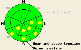
This morning, avalanche danger is LOW for all elevations and aspects. Pockets of MODERATE danger should develop at all elevations on sun-exposed, E-SE-S-SW aspects, 37 degrees and steeper in response to daytime warming. |
|
|
|
Spring weather is on tap for today. Daytime highs should reach into the low 40's above 8000' and upper 40's to low 50's between 7000' and 8000'. Some clouds and increased west and northwest winds should affect the forecast area this afternoon and tonight due to a low-pressure system east of the region. By tomorrow northerly flow and mostly sunny skies should return.
Yesterday, the strong overnight refreeze, cooler daytime temperatures, and cool northerly winds all helped keep any large, widespread wet-snow instabilities from forming. Observations on Mt. Tallac showed a frozen snow surface above 8800' until after 12:30 pm on all aspects. On the northerly aspects below 8800', a breakable crust existed on top of cold, unconsolidated snow in most areas. On the SE-S-SW aspects below 8800', excellent corn conditions existed by 12:00 pm with 2-3 inches of soft melt/freeze snow on the surface and a frozen supportable melt/freeze crust under this soft surface snow. By 2 pm areas of unconsolidated, wet snow 1-2 feet deep had formed near rocks and on slopes with a shallow snowpack on the SE-S-SW aspects. No avalanche activity was reported yesterday.
Today, the warmer air temperatures and intense March sunshine should cause more snow to melt more quickly than yesterday. This melting will dissolve the bonds holding the snow together making the snowpack weaker until the bonds can refreeze tonight. Expect a shorter time-period that occurs earlier in the day for safe and fun snow conditions today. By this afternoon enough melting could occur for wet-snow instabilities to form on steep sun-exposed E-SE-S-SW aspects. Afternoon cloud cover could help limit wet-snow instabilities if the clouds block enough of the sun's radiation. If you find yourself sinking into wet snow up to the top of your boots or start seeing/triggering pinwheels and roller-balls, move to a safer location on either a more westerly aspect, northerly aspect, or low angle terrain.
This morning, avalanche danger is LOW for all elevations and aspects. Pockets of MODERATE danger should develop at all elevations on sun-exposed, E-SE-S-SW aspects, 37 degrees and steeper in response to daytime warming.
| 0600 temperature: | 31 deg. F. |
| Max. temperature in the last 24 hours: | 43-46 deg. F. |
| Average wind direction during the last 24 hours: | Northeast shifting to the west and northwest after midnight |
| Average wind speed during the last 24 hours: | 23 mph |
| Maximum wind gust in the last 24 hours: | 69 mph |
| New snowfall in the last 24 hours: | O inches |
| Total snow depth: | 141 inches |
For 7000-8000 ft: |
|||
| Tuesday: | Tuesday Night: | Wednesday: | |
| Weather: | Mostly sunny in the morning becoming mostly cloudy this afternoon | Mostly cloudy becoming partly cloudy after midnight | Mostly sunny |
| Temperatures: | 44-52 deg. F. | 24-30 deg. F. | 44-51 deg. F. |
| Wind direction: | Northwest | West shifting to the northwest | North |
| Wind speed: | 10 mph increasing to 15-20 mph with gusts to 30 mph in the afternoon | 10-20 mph with gusts to 30 mph decreasing to 10-15 mph after midnight | 10-15 mph with gusts to 25 mph |
| Expected snowfall: | O in. | O in. | O in. |
For 8000-9000 ft: |
|||
| Tuesday: | Tuesday Night: | Wednesday: | |
| Weather: | Mostly sunny in the morning becoming mostly cloudy this afternoon | Mostly cloudy becoming partly cloudy after midnight | Mostly sunny |
| Temperatures: | 38-44 deg. F. | 22-29 deg. F. | 37-43 deg. F. |
| Wind direction: | Northwest | Northwest | North |
| Wind speed: | 10-20 mph increasing to 15-25 mph with gusts to 40 mph in the afternoon | 20-35 mph with gusts to 70 mph | 20-30 mph with gusts to 60 mph |
| Expected snowfall: | O in. | O in. | O in. |


This website is owned and maintained by the non-profit arm of the Sierra Avalanche Center. Some of the content is updated by the USDA avalanche forecasters including the forecasts and some observational data. The USDA is not responsible for any advertising, fund-raising events/information, or sponsorship information, or other content not related to the forecasts and the data pertaining to the forecasts.

