In partnership with: 
|
April 3, 2009 at 6:54 am |
|
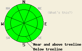
For the vast majority of locations, avalanche danger is LOW. Some small and isolated pockets of instability are possible in the most heavily wind loaded areas near and above treeline on slopes 37 degrees and steeper. These areas of instability are not expected to present a significant hazard to backcountry travelers. |
|
|
|
A weak weather system that moved through the forecast area overnight is winding down. New snow amounts this morning are generally 1 to 2 inches. Remote sensors are reporting some localized areas of new snow accumulation up to 4 inches. Lingering snow showers may produce up to 2 inches of additional snowfall accumulation this morning south of Lake Tahoe. Ridgetop winds have shifted from west to northeast this morning and have decreased from strong to moderate in speed. Air temperatures are in the high single digits and low teens this morning at the upper elevations. On the valley floors, air temperatures are in the mid 20s. Air temperatures are expected to remain cooler today, rising into the 20s and low 30s in most locations.
Yesterday, cloud cover formed early over the northern portion of the forecast area while sunny skies prevailed over the Tahoe Basin and areas to the south. This had a significant affect on the amount of wet surface snow that formed during the day. Observations made on Jake's Peak (West Shore Tahoe area) indicated that significant melting of surface snow had occurred near exposed rocks on E-SE aspects at 9,000' by 10 am. Areas between 7,000' and 9,000' on E-SE aspects that had a deeper snowpack and no exposed rocks remained much more frozen with only the top 1 to 2 inches of snow melting and softening at 11 am. Snow showers moved into the forecast area during the late afternoon and overnight hours. Cold front passage lowered air temperatures significantly overnight. With minimal new snowfall in most locations, the cold air is expected to have created a good refreeze of wet surface snow from yesterday.
Today, expect to find supportable dust on crust conditions in most areas. On more northerly aspects, shallow new snow will exist on top of rough wind affected surfaces or on top of breakable crust. North to northeast winds today are expected to redistribute new snow, minimizing the potential for significant slab formation. A few small and isolated pockets of shallow unstable slabs may exist in the most heavily wind loaded areas. Any avalanche activity that occurs today is expected to be limited to the ridges and is not expected to be large enough to push a person around.
For the vast majority of locations, avalanche danger is LOW. Some small and isolated pockets of instability are possible in the most heavily wind loaded areas near and above treeline on slopes 37 degrees and steeper. These areas of instability are not expected to present a significant hazard to backcountry travelers.
| 0600 temperature: | 16 deg. F. |
| Max. temperature in the last 24 hours: | 30 to 35 deg. F. |
| Average wind direction during the last 24 hours: | West shifting to northeast. |
| Average wind speed during the last 24 hours: | 45 mph |
| Maximum wind gust in the last 24 hours: | 87 mph |
| New snowfall in the last 24 hours: | 1 to 4 inches |
| Total snow depth: | 139 inches |
For 7000-8000 ft: |
|||
| Friday: | Friday Night: | Saturday: | |
| Weather: | Snow showers in the morning south of Lake Tahoe. Partly cloudy skies in the afternoon. | Clear skies. | Sunny skies. |
| Temperatures: | 29 to 35 deg. F. | 7 to 14 deg. F. | 35 to 42 deg. F. |
| Wind direction: | N to NE | N shifting to NE after midnight. | E |
| Wind speed: | 10 to 20 mph with gusts to 35 mph. | 10 to 15 mph with gusts to 30 mph. | Around 10 mph. |
| Expected snowfall: | South of Lake Tahoe up to 2 in. | O in. | O in. |
For 8000-9000 ft: |
|||
| Friday: | Friday Night: | Saturday: | |
| Weather: | Snow showers in the morning south of Lake Tahoe. Partly cloudy skies in the afternoon. | Clear skies. | Sunny skies. |
| Temperatures: | 21 to 29 deg. F. | 5 to 12 deg. F. | 31 to 39 deg. F. |
| Wind direction: | N to NE | N | E |
| Wind speed: | 20 to 30 mph with gusts to 50 mph. | 20 to 30 mph with gusts to 45 mph. | 10 to 20 with gusts to 40 mph. Gusts decreasing to 25 mph in the afternoon. |
| Expected snowfall: | South of Lake Tahoe up to 2 in. | O in. | O in. |


This website is owned and maintained by the non-profit arm of the Sierra Avalanche Center. Some of the content is updated by the USDA avalanche forecasters including the forecasts and some observational data. The USDA is not responsible for any advertising, fund-raising events/information, or sponsorship information, or other content not related to the forecasts and the data pertaining to the forecasts.

