In partnership with: 
|
April 9, 2009 at 6:56 am |
|
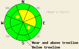
Near and above treeline, areas of MODERATE avalanche danger exist on NW-N-NE-E-SE aspects 37 degrees and steeper. Below treeline, avalanche danger is LOW. |
|
|
|
After a brief break in the weather overnight, another weather system has moved into the forecast area this morning. Snowfall totals over the past 36 hours range from 6 to 10 inches along the Sierra Crest with lower snowfall totals off to the east. Snow shower activity is expected today, increasing in intensity this afternoon. Anywhere from 4 to 15 inches of new snow is expected in the next 36 hours, mainly tonight and Friday morning. This large spread in accumulation amounts indicates a fair degree of uncertainty in the precipitation portion of the weather forecast. Air temperatures this morning are in the upper teens and 20s at most locations. Air temperatures are expected to rise into the mid to upper 30s in most areas. Ridgetop winds this morning are moderate in speed out of the southwest and are forecast to continue through tonight.
Yesterday, observation made on Mt. Judah (Donner Summit area) revealed 4 to 6 inches of new snow in the area. NE-E aspects near treeline were wind loaded with up to 20 inches of new snow. Human triggered avalanches occurred easily in wind loaded areas in response to human triggered cornice collapse and ski cuts. Avalanches were observed to have occurred at 8,200' on NE-E aspect, 38 to 46 degree slopes with crowns around 1 foot deep. The snowpack was observed to fail within the new snow about 4 inches above the melt-freeze crust that exists at the old/new snow interface. Good bonding of the new snow to the crust below was observed. On Powerhouse and Waterhouse Peaks (Luther Pass area), very similar snowpack conditions were observed. Around 6 inches of new snow was well bonded to the melt-freeze crust below on NW-N-NE aspects all the way up to 9,300'. On the summit, areas of wind loading up to 16 inches deep were observed. Stability tests identified a very easy shear with fracture propagation occurring around 4 inches above the melt-freeze crust at the base of the new snow. This was very similar to observations from Mt. Judah. Bonding at the old/new snow interface was good with all failure noted within the new snow. No slab formation or sluff activity was observed below treeline. Areas of warming instability were noted on southerly aspects, with small natural roller balls observed in a variety of locations on the West Shore of Lake Tahoe and Donner Summit. Remote sensors report up to 3 inches of settlement has occurred within the new snow over the past 24 hours.
Today, continued instability is expected in wind loaded areas near and above treeline, mainly on N-NE-E aspects. With a couple inches of new snow early this morning and possibly a few more during the day today, new instabilities within the storm snow are expected to form. Decreased snowfall rates overnight and this morning, continued bonding, and settlement within the new snow are expected to decrease the distribution of human triggered avalanches today as compared to yesterday. Duplicating yesterday's easy shear within the storm snow may prove difficult. New shears higher in the storm snow layer will more likely be found today. Enough new snow has accumulated that the danger of human triggered avalanches that are large enough to bury a person exists. If sun breaks occur, isolated areas of warming instability are possible today on southerly aspects below 8,500'.
Near and above treeline, areas of MODERATE avalanche danger exist on NW-N-NE-E-SE aspects 37 degrees and steeper. Below treeline, avalanche danger is LOW.
| 0600 temperature: | 21 deg. F. |
| Max. temperature in the last 24 hours: | 26 deg. F. |
| Average wind direction during the last 24 hours: | Southwest |
| Average wind speed during the last 24 hours: | 41 mph |
| Maximum wind gust in the last 24 hours: | 74 mph |
| New snowfall in the last 24 hours: | 1 to 3 inches |
| Total snow depth: | 139 inches |
For 7000-8000 ft: |
|||
| Thursday: | Thursday Night: | Friday: | |
| Weather: | Mostly cloudy skies with scattered snow showers in the morning. Numerous snow showers in the afternoon. | Cloudy skies with snow. | Cloudy skies with scattered snow showers. |
| Temperatures: | 35 to 41 deg. F. | 18 to 25 deg. F. | 31 to 38 deg. F. |
| Wind direction: | SW | SW | Variable |
| Wind speed: | 10 to 15 mph with gusts to 30 mph in the afternoon. | 10 to 15 mph with gusts up to 25 mph in the evening. | Light winds. |
| Expected snowfall: | Up to 3 in. | 1 to 4 in. | Up to 4 in. |
For 8000-9000 ft: |
|||
| Thursday: | Thursday Night: | Friday: | |
| Weather: | Mostly cloudy skies with scattered snow showers in the morning. Numerous snow showers in the afternoon. | Cloudy skies with snow. | Cloudy skies with scattered snow showers. |
| Temperatures: | 30 to 36 deg. F. | 18 to 24 deg. F. | 26 to 33 deg. F. |
| Wind direction: | SW | SW | S |
| Wind speed: | 20 to 30 mph with gusts to 45 mph. | 15 to 25 mph with gusts to 40 mph. | Up to 10 mph in the morning, becoming light. |
| Expected snowfall: | Up to 3 in. | 2 to 7 in. | Up to 5 in. |


This website is owned and maintained by the non-profit arm of the Sierra Avalanche Center. Some of the content is updated by the USDA avalanche forecasters including the forecasts and some observational data. The USDA is not responsible for any advertising, fund-raising events/information, or sponsorship information, or other content not related to the forecasts and the data pertaining to the forecasts.

