In partnership with: 
|
April 19, 2009 at 6:46 am |
|
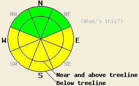
This morning the avalanche danger is LOW. Areas of MODERATE avalanche danger should quickly develop due to daytime warming on E-SE-S-SW-W aspects 37 degrees and steeper at all elevations today. |
|
|
|
After another night of above freezing temperatures, daytime highs should climb into the mid to upper 50's above 7000' today. By tomorrow the forecast area could see record high temperatures. This high pressure should remain over the forecast area into at least the middle of the week. The forecast calls for light north and east winds through tomorrow.
On Mount Judah by 10:30 am yesterday, 2-3 inches of wet corn snow existed on the surface of the sun-exposed E-SE-S aspects up to 8200'. The SW-W aspects quickly followed suit, and by 11:00 am similar conditions existed on these aspects. Some small human-triggered roller balls occurred on a 39 degree, SE facing test-slope at 7900' at 12:00 pm. A mix of supportable and breakable crusts, wind scoured surfaces, and a few patches of heavy, unconsolidated snow existed on the NW-N-NE aspects above 7500'. Below 7500' melt-freeze conditions existed on any slope that receives sunshine.
Today's main avalanche concern will be wet-snow instabilities. After an overnight refreeze due to radiational cooling, the snow surface should melt and soften quickly today due to warm daytime temperatures and the intense April sun. This melting will produce free water in to the snowpack which will weaken the snowpack by dissolving the bonds between the snow grains. Enough warming and melting could occur for human-triggered, wet-snow instabilities like roller balls, pinwheels, and small point-release avalanches to be possible today. The most likely areas for these instabilities will be on steep, sun-exposed, E-SE-S-SW-W aspects. Well established drainage channels that prevent free water from saturating any one layer in the snowpack should keep wet-slab avalanches unlikely. However, they are not impossible especially in areas where the snowpack sits on an impermeable ground surface like a granite slab. Plan to be off of any sun exposed slopes before they get too soft and wet. To help determine when a slope has become unsafe, use observations of surface wet-snow instabilities and simple tests like stepping into the snow (if you sink into wet snow above your ankles it is a good time to move to a different slope).
This morning the avalanche danger is LOW. Areas of MODERATE avalanche danger should quickly develop due to daytime warming on E-SE-S-SW-W aspects 37 degrees and steeper at all elevations today.
| 0600 temperature: | 38-40 deg. F. |
| Max. temperature in the last 24 hours: | 51-55 deg. F. |
| Average wind direction during the last 24 hours: | Northeast |
| Average wind speed during the last 24 hours: | 15 mph |
| Maximum wind gust in the last 24 hours: | 36 mph |
| New snowfall in the last 24 hours: | O inches |
| Total snow depth: | 132 inches |
For 7000-8000 ft: |
|||
| Sunday: | Sunday Night: | Monday: | |
| Weather: | Sunny | Clear | Sunny |
| Temperatures: | 54-61 deg. F. | 33-41 deg. F. | 58-65 deg. F. |
| Wind direction: | Northeast | Variable | Northeast |
| Wind speed: | up to 10 mph | Light | up to 10 mph |
| Expected snowfall: | O in. | O in. | O in. |
For 8000-9000 ft: |
|||
| Sunday: | Sunday Night: | Monday: | |
| Weather: | Sunny | Clear | Sunny |
| Temperatures: | 52-58 deg. F. | 35-41 deg. F. | 56-62 deg. F. |
| Wind direction: | Northeast | Variable | East |
| Wind speed: | 10 mph with gusts to 25 mph in the morning | Light | 10 mph |
| Expected snowfall: | O in. | O in. | O in. |


This website is owned and maintained by the non-profit arm of the Sierra Avalanche Center. Some of the content is updated by the USDA avalanche forecasters including the forecasts and some observational data. The USDA is not responsible for any advertising, fund-raising events/information, or sponsorship information, or other content not related to the forecasts and the data pertaining to the forecasts.

