In partnership with: 
|
April 24, 2009 at 7:00 am |
|
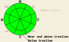
Today, the avalanche danger should remain LOW for all aspects and elevations. Some minor sluffing may occur in the new snow today. Some very small, isolated, human-triggerable winds slabs may form on N-NE-E aspects near and above treeline by this afternoon. |
|
|
|
A strong cold front moving through the forecast area should bring scattered, light snow showers through Saturday. Due to the lack of moisture associated with this system only a few inches of snow should accumulate. Temperatures should stay much colder today and tonight before they start to gradually warm up over the weekend. The southwest winds should remain strong until tonight when the front starts to move east of the forecast area. By tomorrow, the winds should diminish and shift to the north and east.
Yesterday marked the last day of continuous above freezing temperatures. By yesterday afternoon, several inches of wet, unconsolidated snow existed on the southerly aspects and on some sun-exposed northerly aspects on Incline Lake Peak in the Mt. Rose area. At 12:30 pm some small, human-triggered roller-balls occurred on a 39 degree SE aspect at 8600'. No other avalanche activity was reported.
As temperatures dropped below freezing last night, the snow should have started to refreeze. As long as the skies stay cloudy and the temperatures stay below freezing, this refreeze should continue. The refreeze will strengthen the snowpack by turning the water in the snowpack into ice that glues the snow together. While the snow remains frozen, avalanche activity in the old snow will remain unlikely.
Even though the winds will transport snow and form some wind slabs on the N-NE-E aspects today, the 1-2 inches of new snow that fell last night combined with up to 2 more inches of snow at the higher elevations today should not be enough for any large, dangerous wind slabs to form. A few pockets of small human-triggerable wind slabs and fragile cornices may form on the most heavily wind-loaded slopes near and above treeline by this afternoon. Slab avalanche activity due to this wind loading should remain very small and isolated. Most avalanche activity today should be limited to small sluffs occurring in the new snow.
Today, the avalanche danger should remain LOW for all aspects and elevations. Some minor sluffing may occur in the new snow today. Some very small, isolated, human-triggerable winds slabs may form on N-NE-E aspects near and above treeline by this afternoon.
| 0600 temperature: | 22 deg. F. |
| Max. temperature in the last 24 hours: | 48 deg. F. |
| Average wind direction during the last 24 hours: | Southwest |
| Average wind speed during the last 24 hours: | 37-50 mph |
| Maximum wind gust in the last 24 hours: | 65-78 mph |
| New snowfall in the last 24 hours: | 0-2 inches |
| Total snow depth: | 121 inches |
For 7000-8000 ft: |
|||
| Friday: | Friday Night: | Saturday: | |
| Weather: | Show showers | Cloudy with scattered snow showers | Mostly cloudy with scattered snow showers in the morning becoming partly cloudy in the afternoon |
| Temperatures: | 32-40 deg. F. | 18-25 deg. F. | 34-41 deg. F. |
| Wind direction: | Southwest | West shifting to the north | Northeast |
| Wind speed: | 20-30 mph with gusts to 45 mph | 10-15 mph with gusts to 25 mph | 10 mph |
| Expected snowfall: | up to 1 in. | trace in. | O in. |
For 8000-9000 ft: |
|||
| Friday: | Friday Night: | Saturday: | |
| Weather: | Show showers | Cloudy with scattered snow showers | Mostly cloudy with scattered snow showers in the morning becoming partly cloudy in the afternoon |
| Temperatures: | 25-35 deg. F. | 13-23 deg. F. | 28-38 deg. F. |
| Wind direction: | Southwest | West shifting to the north | North |
| Wind speed: | 30-45 mph with gusts between 65 and 80 mph | 15-25 mph with gusts to 35 mph | 10-20 mph with gusts to 30 mph |
| Expected snowfall: | up to 2 in. | trace in. | O in. |


This website is owned and maintained by the non-profit arm of the Sierra Avalanche Center. Some of the content is updated by the USDA avalanche forecasters including the forecasts and some observational data. The USDA is not responsible for any advertising, fund-raising events/information, or sponsorship information, or other content not related to the forecasts and the data pertaining to the forecasts.

