In partnership with: 
|
November 22, 2009 at 8:20 am |
|
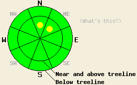
Complex conditions exist during the early season. On N-NE aspects above 8800 ft and steeper than 32 degrees where the combination of facets on top of an ice layer with new snow above exists the avalanche danger is MODERATE . Human-triggered avalanches will be possible on these slopes today. |
|
|
|
A low pressure system north of the forecast area should bring some light snow and strong westerly winds to the area this morning. The forecast calls for up to 2" of additional snow along the Northern Sierra Crest. Both the winds and the snow should decrease through the day. The skies should start to clear as a high pressure ridge begins to build over the forecast area. This ridge should bring clear skies and light east winds to the forecast area by Monday. The forecast calls for the clear weather to remain through most of next week.
Yesterday, observers reported one small (8" crown, 15' wide), human-triggered avalanche on a 38 degree NE aspect at 8900' in the Mt. Rose area. This slide failed on the weak facet layer above October's ice layer. In the more exposed terrain at higher elevations in the Mt. Rose area the 8" to 10" of new snow fell directly on top of the ice crust. Layer bonding tests indicated that this new snow seems to be bonding well to the ice crust. The facet layer did not exist in these higher more exposed areas. Backcountry skiers reported a large (5' crown, 30-40' wide) avalanche on the north side of Round Top in the Carson Pass area yesterday. Another observer in the Carson Pass area saw shooting cracks and heard whumpfing noises on a N aspect on the SW ridge of Red Lake Peak at 9000'-9100'. A snowpit in this area found the old facet layer below the new snow. Higher on the peak in more exposed terrain another observer reported that wind had scoured the N-NE aspects back to the October ice crust. All observers reported very thin coverage below 9000' on all aspects. On the SE-S-SW-W-NW aspects the snow cover remains thin at all elevations. Combined with previous observations on Mt. Rose, Barker Pass, Elephant's Back, and Mt. Lola, this information all points to a highly variable snowpack across the forecast area. Where the October ice layer has facets on top of it the snowpack remains weak; however, this layer only exists in certain places. This layer will most likely remain on N-NE aspects above 8800'. Digging quick test pits or hand pits often during the day will be the best way to determine if this layer exists on any particular slope.
In the areas where the facets do exist human-triggered avalanche activity remains possible. Wind loading that occurred on some of the N-NE aspects above 8800' also deposited a heavy wind slab on some of these slopes. In the areas where the combination of this wind slab, the weak facet layer, and the ice layer as a bed surface larger avalanche activity will remain possible today. The shallow snowpack also provide reasons for concern. The new snow just barely covers the myriad of rocks, dirt, stumps, shrubbery, and other knee shattering obstacles. This unconsolidated snow will allow people to hit the ground with almost every turn in many areas. Use extra caution if traveling in the backcountry today.
Complex conditions exist during the early season. On N-NE aspects above 8800 ft and steeper than 32 degrees where the combination of facets on top of an ice layer with new snow above exists the avalanche danger is MODERATE . Human-triggered avalanches will be possible on these slopes today.
| 0600 temperature: | 24 deg. F. |
| Max. temperature in the last 24 hours: | 27 deg. F. |
| Average wind direction during the last 24 hours: | West |
| Average wind speed during the last 24 hours: | 20 mph increasing to 35 mph |
| Maximum wind gust in the last 24 hours: | 80 mph |
| New snowfall in the last 24 hours: | O inches |
| Total snow depth: | 6-24 inches |
For 7000-8000 ft: |
|||
| Sunday: | Sunday Night: | Monday: | |
| Weather: | Partly cloudy with light snow showers this morning | Partly cloudy | Partly cloudy |
| Temperatures: | 30-37 deg. F. | 20-29 deg. F. | 38-45 deg. F. |
| Wind direction: | West | Northwest | East |
| Wind speed: | 15-25 mph with gusts to 40 mph | 10-15 mph with gusts to 30 mph becoming light after midnight | 10 mph |
| Expected snowfall: | up to 2 in. | O in. | O in. |
For 8000-9000 ft: |
|||
| Sunday: | Sunday Night: | Monday: | |
| Weather: | Partly cloudy with light snow showers this morning | Partly cloudy | Partly cloudy |
| Temperatures: | 23-30 deg. F. | 20-26 deg. F. | 33-40 deg. F. |
| Wind direction: | West | Northwest shifting to Northeast | Northeast |
| Wind speed: | 35-55 mph with gusts to 85 mph decreasing in the afternoon | 20-30 mph with gusts to 60 mph decreasing to 15-25 mph with gusts to 45 mph in the afternoon | 10-15 mph with gusts to 35 mph |
| Expected snowfall: | up to 2 in. | O in. | O in. |


This website is owned and maintained by the non-profit arm of the Sierra Avalanche Center. Some of the content is updated by the USDA avalanche forecasters including the forecasts and some observational data. The USDA is not responsible for any advertising, fund-raising events/information, or sponsorship information, or other content not related to the forecasts and the data pertaining to the forecasts.

