In partnership with: 
|
November 29, 2009 at 8:00 am |
|
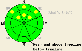
LOW avalanche danger exists across most of the forecast area. Some isolated pockets of MODERATE danger may still remain on NW-N-NE aspects steeper than 32 degrees above 8700'. |
|
|
|
The strong Northeast winds continued through the night averaging 50-55 mph over the Sierra Crest and 30-35 mph east of Lake Tahoe. These winds should start to decrease today as high pressure ridge starts to build over the forecast area. The forecast calls for this ridge to bring sunny skies, warmer temperatures, and light winds to the region for the early part of this week.
Observations from the Mt. Rose area and from Carson Pass yesterday indicated that the NE winds had scoured most of the exposed NW-N-NE-E aspects. In many places these winds exposed the Oct. ice layer. These winds transported new snow onto bare ground in most places. In both areas some isolated human-triggered cracking and collapsing did occur where small wind slabs had formed on NW aspects above 8700' due to cross loading. The slabs remained small and discontinuous. Observations showed that a mix of wind scoured ice, some discontinuous hard slabs, patches of unconsolidated new snow, and exposed rocks exist as the surface on most NW-N-NE-E aspects. The fragile combination of the Oct 19th facet layer on top of the early Oct. ice layer seems to be growing more isolated and disconnected. On other aspects thin, unconsolidated snow barely covers rocks, stumps, logs, dirt, and other toy-damaging, knee-breaking obstacles.
Today, the combination of the weak layer (the facets) and a slippery bed surface (the ice layer) will remain the primary avalanche concern. Even though the NE winds have caused this weak combination to become more isolated and disconnected, it still exists in some areas. On the few NW-N-NE slopes protected from the strong NE winds some human-triggerable avalanche activity may still remain possible. Cross-loaded NW aspects above 8700' that have this layer combination will be the most suspect slopes. Probing with a ski pole and quick hand pits can indicate if the facet/ice layer combination exists under the surface.
Use extra cation in the backcountry today. A persistent weak layer with variable strength and distribution provides a complex avalanche hazard. Along with the avalanche hazard the early season snowpack just barely covers the myriad of rocks, dirt, stumps, shrubbery, and other season-ending obstacles.
LOW avalanche danger exists across most of the forecast area. Some isolated pockets of MODERATE danger may still remain on NW-N-NE aspects steeper than 32 degrees above 8700'.
| 0600 temperature: | 22 deg. F. |
| Max. temperature in the last 24 hours: | 25 deg. F. |
| Average wind direction during the last 24 hours: | East Northeast |
| Average wind speed during the last 24 hours: | 55 mph |
| Maximum wind gust in the last 24 hours: | 107 mph |
| New snowfall in the last 24 hours: | 0-1 inches |
| Total snow depth: | 9-25 inches |
For 7000-8000 ft: |
|||
| Sunday: | Sunday Night: | Monday: | |
| Weather: | Sunny | Clear | Sunny |
| Temperatures: | 37-42 deg. F. | 27-37 deg. F. | 45-50 deg. F. |
| Wind direction: | Northeast | East | Southeast |
| Wind speed: | 10-20 mph with gusts to 30 mph | 10-20 mph with gusts to 30 mph | 10 mph becoming light and variable in the afternoon |
| Expected snowfall: | O in. | O in. | O in. |
For 8000-9000 ft: |
|||
| Sunday: | Sunday Night: | Monday: | |
| Weather: | Sunny | Clear | Sunny |
| Temperatures: | 34-39 deg. F. | 30-37 deg. F. | 41-46 deg. F. |
| Wind direction: | Northeast | East | Southeast |
| Wind speed: | 30-45 mph with gusts to 75 mph decreasing to 20-30 mph with gusts to 50 mph | 10-20 mph with gusts to 35 mph | 10-15 mph decreasing in the afternoon |
| Expected snowfall: | O in. | O in. | O in. |


This website is owned and maintained by the non-profit arm of the Sierra Avalanche Center. Some of the content is updated by the USDA avalanche forecasters including the forecasts and some observational data. The USDA is not responsible for any advertising, fund-raising events/information, or sponsorship information, or other content not related to the forecasts and the data pertaining to the forecasts.

