In partnership with: 
|
December 3, 2009 at 7:28 am |
|
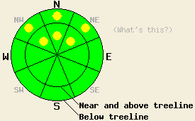
LOW avalanche danger exists in most areas. However, pockets of MODERATE avalanche danger remain on NW-N-NE aspects above 8,000' in near-treeline and below-treeline areas on slopes 32 degrees and steeper. |
|
|
|
The high-pressure ridge should remain over the forecast area through Friday. It should keep the weather clear and dry. The winds should start to increase tomorrow ahead of a low-pressure system that should impact the region this weekend.
The Oct. 19th facet layer remains as a persistent weak layer. Observations from across the forecast area continue to find this layer sitting on top of a slippery ice crust on NE-wind-protected, NW-N-NE aspects above 8600'. In areas where a slab exists on top of these facets, the snowpack remains unstable. In those areas where the NE wind did not scour the snow surface back to the ice crust, it left a stiff wind slab sitting on top of the weak facets. Whumpfing and snowpack collapse occurred due to failure of these facets in the Mt. Rose area again yesterday. Layer bonding tests in the Mt. Lola area also showed that when these facets break the fracture can propagate through the snowpack along this layer. In areas where this layer exists with a slab above it, but without the ice layer below it, layer bonding tests showed similar results as low as 8000' on N-NE aspects.
Failure of the Oct. 19th facet layer will continue to comprise the primary avalanche concern today. On slopes where this layer exists with a slab on top of it, the additional weight of a person may be enough to break this layer and result in an avalanche. The NW-N-NE aspects near and below treeline above 8000' will be the most likely to hold this combination of a weak layer with a slab above it. Quick hand pits or probing with a ski pole can identify whether the soft, sugary Oct 19 facet layer exists in the snowpack. In areas where this layer exists either on top of an ice layer or on top of the ground, slopes steeper than 32 degrees hold the potential for human-triggered avalanches.
Use extra caution in the backcountry today. A persistent weak layer with variable strength and distribution provides a complex avalanche hazard. Along with the avalanche hazard, the early season snowpack just barely covers the myriad of rocks, dirt, stumps, shrubbery, and other toy-damaging, knee-breaking obstacles.
LOW avalanche danger exists in most areas. However, pockets of MODERATE avalanche danger remain on NW-N-NE aspects above 8,000' in near-treeline and below-treeline areas on slopes 32 degrees and steeper.
| 0600 temperature: | 26 deg. F. |
| Max. temperature in the last 24 hours: | 42 deg. F. |
| Average wind direction during the last 24 hours: | East Northeast |
| Average wind speed during the last 24 hours: | 20 mph |
| Maximum wind gust in the last 24 hours: | 31 mph |
| New snowfall in the last 24 hours: | O inches |
| Total snow depth: | 8-21 inches |
For 7000-8000 ft: |
|||
| Thursday: | Thursday Night: | Friday: | |
| Weather: | Sunny | Clear | Partly cloudy |
| Temperatures: | 40-45 deg. F. | 27-33 deg. F. | 41-46 deg. F. |
| Wind direction: | Northeast | Variable | Becoming southwest in the afternoon |
| Wind speed: | 10 mph | Light | Increasing to 10 mph in the afternoon |
| Expected snowfall: | O in. | O in. | O in. |
For 8000-9000 ft: |
|||
| Thursday: | Thursday Night: | Friday: | |
| Weather: | Sunny | Clear | Partly cloudy |
| Temperatures: | 37-41 deg. F. | 27-32 deg. F. | 37-42 deg. F. |
| Wind direction: | Northeast | East shifting to the southeast | West |
| Wind speed: | 10-15 mph with gusts to 30 mph | 10 mph | 10 mph increasing to 10-15 mph with gusts to 25 mph in the afternoon |
| Expected snowfall: | O in. | O in. | O in. |


This website is owned and maintained by the non-profit arm of the Sierra Avalanche Center. Some of the content is updated by the USDA avalanche forecasters including the forecasts and some observational data. The USDA is not responsible for any advertising, fund-raising events/information, or sponsorship information, or other content not related to the forecasts and the data pertaining to the forecasts.

