In partnership with: 
|
December 7, 2009 at 8:00 am |
|
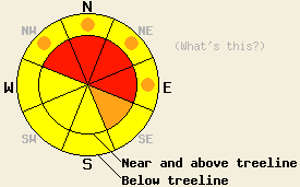
Near and above treeline, avalanche danger is HIGH on NW-N-NE-E aspects 34 degrees and steeper. Below treeline, avalanche danger is MODERATE with pockets of CONSIDERABLE danger in open areas on NW-N-NE-E aspects and in creek beds 34 degrees and steeper. |
|
|
|
A cold storm is currently impacting the forecast area. Snow level is down around 900' this morning. This is producing uncommonly low density snow for this region. Storm snow accumulations are running 10 to 15 inches along the Sierra Crest south of Hwy 50 and in the Carson Range while 18 to 25 inches have accumulated along the Sierra Crest north of Hwy 50. An additional 8 to 16 inches is expected to fall across the forecast area today and an another 1 to 4 inches tonight. Remote sensors above 8,000' are reporting air temperatures in the low teens and single digits this morning. Ridgetop winds have gradually shifted from southwest to west over the past 24 hours. Wind are expected to shift back to southwest and decrease to moderate in speed today after peaking with ridge gusts over 100 mph mid day Sunday.
Yesterday, observations made on Tamarack Peak (Mount Rose area) on NW-N-NE aspects near and below treeline between 8,900' and 9,200' indicated that the persistent weak instability of the October 19 facet layer that has been observed in this area since mid November is continuing to gain strength and become nonreactive (pit profile here). Observations made within the Mt.Rose Ski Area in a uncontrolled, natural state snowpack indicated that new snow was bonding well to the old snow surface during the afternoon hours. Observations made Saturday on Silver Peak (Pole Creek area) at 8,100' on a N aspect 31 degree avalanche path near treeline indicated that the Oct 19 layer was still reactive (pit profile here). It is important to understand that instability involving the Oct 19 facet layer will not disappear in a uniform fashion across in all areas. Instability will become more spatially variable over terrain, requiring slope by slope snowpack assessment in order to accurately determine local slope stability.
Today, most instability is expected to focus around new snow and occur in wind loaded areas. This will mainly occur near and above treeline on NW-N-NE-E-SE aspects. A second concern exists for deep slab instability involving the Oct 19 facet layer. This layer exists above 8,000' in near treeline and below treeline terrain on NW-N-NE aspects that receive some degree of shelter from NE winds. The Oct 19 layer sits on the ground between 8,000' and 8,600' and on top of the early Oct ice mass above 8,600'. A third concern exists near creek beds with recently open water sources where surface hoar was observed over the weekend in a variety of locations. This surface hoar is now a buried weak layer in many creek bed areas which act as CONSIDERABLE avalanche danger exists on N-NE-E aspects 32 degrees and steeper. Pockets of CONSIDERABLE danger exist on NW aspects. Below treeline pockets of CONSIDERABLE danger exist on NW-N-NE-E aspects 32 degrees and steeper.
Near and above treeline, avalanche danger is HIGH on NW-N-NE-E aspects 34 degrees and steeper. Below treeline, avalanche danger is MODERATE with pockets of CONSIDERABLE danger in open areas on NW-N-NE-E aspects and in creek beds 34 degrees and steeper.
| 0600 temperature: | deg. F. |
| Max. temperature in the last 24 hours: | 3 deg. F. |
| Average wind direction during the last 24 hours: | 17 |
| Average wind speed during the last 24 hours: | West southwest shifting to the northeast then back to the west southwest mph |
| Maximum wind gust in the last 24 hours: | 15 mph |
| New snowfall in the last 24 hours: | 28 inches |
| Total snow depth: | North of Hwy 50: 2-3 inches - South of Hwy 50 4-6 inches |
For 7000-8000 ft: |
|||
| Monday: | Monday Night: | Tuesday: | |
| Weather: | 26-40 | Sunny | Partly cloudy becoming mostly cloudy after midnight |
| Temperatures: | Mostly cloudy deg. F. | 12 to 19 deg. F. | 2 below zero to 5 deg. F. |
| Wind direction: | Southwest | Southwest | Southwest |
| Wind speed: | Southwest | 10-15 mph | 10-15 mph decreasing after midnight |
| Expected snowfall: | 10-15 mph with gusts to 30 mph in. | O in. | O in. |
For 8000-9000 ft: |
|||
| Monday: | Monday Night: | Tuesday: | |
| Weather: | Mostly cloudy | Sunny | Partly cloudy becoming mostly cloudy after midnight |
| Temperatures: | 21 to 28 deg. F. | 10 to 17 deg. F. | 1 to 8 deg. F. |
| Wind direction: | Southwest | West southwest | west |
| Wind speed: | 10 mph | 10-20 mph with gusts to 35 mph | 10-15 mph with gusts to 35 mph |
| Expected snowfall: | O in. | O in. | O in. |


This website is owned and maintained by the non-profit arm of the Sierra Avalanche Center. Some of the content is updated by the USDA avalanche forecasters including the forecasts and some observational data. The USDA is not responsible for any advertising, fund-raising events/information, or sponsorship information, or other content not related to the forecasts and the data pertaining to the forecasts.

