In partnership with: 
|
December 9, 2009 at 7:58 am |
|
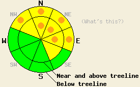
Pockets of CONSIDERABLE avalanche danger exist on NW-N-NE-E aspects steeper than 35 degrees at all elevations. MODERATE danger exists on cross-loaded NW and SE aspects steeper than 35 degrees near and above treeline. |
|
|
|
A strong inversion exists over the forecast area with temperatures in the Sierra Valleys below zero. Temperatures above 8000' have risen into the low teens. The high pressure ridge should remain in place today keeping the weather clear and cold. As the ridge starts to break down tonight temperatures, and cloud cover should start to increase over the forecast area. By tomorrow a few minor storms could start to impact the area with a chance for some light snow.
Yesterday, observers reported small, natural avalanches on Elephant's Back (near Carson Pass) and on Mt. Judah (near Donner Summit). Both of these slides occurred above treeline near ridgetops. Both slides had 6"-15" crowns. They both occurred on steep (37-40 degree) N-E facing slopes. In each of these areas, the stiff, newly-formed wind slabs overloaded the unconsolidated, new snow below them. Observers also reported continued wind loading (photo) across the forecast area all day yesterday. Mt. Rose Ski Patrol reported several small, natural avalanches in closed, uncontrolled areas. These slides started below treeline hundreds of feet below their historical/normal start zones in steep N-E facing terrain. The crowns on these slides ranged from 6"-10". Observers in the Ophir Creek area (Mt. Rose backcountry), on Carson Pass, and on Mt. Judah also reported widespread whumpfing and snowpack collapse near and below treeline. On Mt. Judah this collapse occurred as old, persistent weak layers (facets near a rain crust) broke under the additional weigh of a person. Observers reported that the persistent weak layers are becoming more variable in distribution and strength. Where these layers exist, layer bonding tests still indicate that once they break, the fracture can propagate through the snowpack along these layers.
Avalanche concern #1:
Today, in areas where a persistent weak layer exists underneath the new snow, natural avalanches remain possible, and human-triggered avalanches will be likely. These weak layers could include the Oct. 19th facet layer or the facets near the thin rain crust. Probing with a ski pole or digging quick hand pits can easily identify where these weak layers remain. These weak layers will most likely exist on sheltered NW-N-NE-E aspects near and below treeline that had some protection from the E-NE winds that scoured slopes in Nov. The new snow should gain strength faster than these weak layers. As the new snow becomes more cohesive and slab-like, these layers could become more reactive. Any slopes steeper than 34 degrees where these persistent weak layers exist hold the potential for human-triggered avalanche activity.
Avalanche concern #2:
The southwest winds have continued to transport snow since the end of the storm. This wind loading has formed new wind slabs on the N-NE-E aspects. These slabs will be most prevalent near and above treeline on open slopes near ridgelines. These slabs will continue to grow as the southwest winds continue to move snow. These newly formed wind slabs will be sitting on weak, unconsolidated new snow, old ice crusts, wind scoured surfaces, and in some areas on top of the previously mentioned weak layers. This instability could remain active today. Use clues like drifted snow, cornices, ripples, and other wind created textures to determine where wind-loading has occurred. Wind-loaded slopes steeper than 35 degrees will also hold avalanche potential today.
Pockets of CONSIDERABLE avalanche danger exist on NW-N-NE-E aspects steeper than 35 degrees at all elevations. MODERATE danger exists on cross-loaded NW and SE aspects steeper than 35 degrees near and above treeline.
| 0600 temperature: | 12 deg. F. |
| Max. temperature in the last 24 hours: | 16 deg. F. |
| Average wind direction during the last 24 hours: | West Southwest |
| Average wind speed during the last 24 hours: | 20-30 mph |
| Maximum wind gust in the last 24 hours: | 51 mph |
| New snowfall in the last 24 hours: | O inches |
| Total snow depth: | 23-35 inches |
For 7000-8000 ft: |
|||
| Wednesday: | Wednesday Night: | Thursday: | |
| Weather: | Sunny in the morning becoming partly cloudy this afternoon | Mostly cloudy | Mostly cloudy with a slight chance of snow in the afternoon |
| Temperatures: | 20-27 deg. F. | 15-21 deg. F. | 24-31 deg. F. |
| Wind direction: | Southwest | West | Southwest |
| Wind speed: | up to 10 mph | 10 mph | 10 mph |
| Expected snowfall: | O in. | O in. | trace in. |
For 8000-9000 ft: |
|||
| Wednesday: | Wednesday Night: | Thursday: | |
| Weather: | Sunny in the morning becoming partly cloudy this afternoon | Mostly cloudy | Mostly cloudy with a slight chance of snow in the afternoon |
| Temperatures: | 19-26 deg. F. | 16-23 deg. F. | 21-28 deg. F. |
| Wind direction: | Southwest | West | West |
| Wind speed: | 10-20 mph with gusts to 35 mph | 10-15 mph | 10-15 mph with gusts to 30 mph |
| Expected snowfall: | O in. | O in. | trace in. |


This website is owned and maintained by the non-profit arm of the Sierra Avalanche Center. Some of the content is updated by the USDA avalanche forecasters including the forecasts and some observational data. The USDA is not responsible for any advertising, fund-raising events/information, or sponsorship information, or other content not related to the forecasts and the data pertaining to the forecasts.

