In partnership with: 
|
December 10, 2009 at 8:01 am |
|
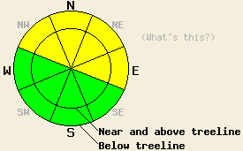
MODERATE avalanche danger exists on NW-N-NE-E aspects steeper than 35 degrees at all elevations. |
|
|
|
This evening the first of two storm systems should reach the forecast area. Southwest winds and cloud cover should increase ahead of this storm. This system should bring more snow to the mountains with 4-8 inches predicted between 7000'-8000' and 6-10" above 8000'. Snow levels should remain low through this first storm. This storm should begin to taper off by Friday afternoon. The second stronger, wetter storm should move into the the forecast area Friday night.
Remote sensors across the forecast area have reported 5-8" of settlement and consolidation since the end of the storm. Observations from Castle Peak and Silver Peak yesterday showed a slight strengthening trend in the snowpack. In the Sliver Peak area whumpfing and snowpack collapse still occurred between 6400' and 7800' on N and NE aspects. However, these collapses were much smaller and more isolated than the ones from previous days. These human-triggered collapses occurred due to failure of facets near the Nov. 22nd rain crust. Snowpit tests on higher elevation slopes in the Silver Peak area and on Castle Peak showed that persistent weak layers (the facets near the Nov. 22 rain crust and the Oct. 19th facets) still exist. These same tests also indicated that the risk of fracture propagation along these layers has diminished. Observations continue to indicate these persistent weak layers are becoming more variable in distribution and strength. In some areas, they can support a person's weight on the snowpack. In others, they cannot. Near and above treeline small, stiff, wind slabs formed by southwest winds do exist in both of these areas. These wind slabs have not bonded well to the light unconsolidated snow below them and failed easily in the layer bonding tests. No new avalanche activity was reported yesterday.
Avalanche concern #1:
The recently formed wind slabs on the N-NE-E aspects could remain active today. These slabs sit on weak, unconsolidated new snow, old ice crusts, wind scoured surfaces, and in some areas on top of old weak layers. These slabs will be most prevalent near and above treeline on open slopes near ridgelines. Observations continue to indicate that these slabs remain sensitive to human-triggering. Even though most of these slabs are small, they could entrain enough snow to drag a person off his/her feet and through areas of barely covered rocks, trees, and other club-like objects. In the most heavily wind-loaded areas some of these slabs could be large. Use clues like drifted snow, cornices, ripples, and other wind created textures to determine where wind-loading has occurred. Wind-loaded slopes steeper than 35 degrees will hold avalanche potential today.
Avalanche concern #2:
Even though the snowpack seems to be gaining strength, human-triggered avalanches will still be possible in areas where a persistent weak layer exists underneath the new snow. These weak layers could include the Oct. 19th facet layer or the facets near the Nov. 22nd rain crust. Probing with a ski pole or digging quick hand pits can easily identify where these weak layers remain. These weak layers will most likely exist on sheltered NW-N-NE-E aspects near and below treeline. The new snow is gaining strength faster than these weak layers. As the new snow becomes more cohesive and slab-like, these layers could become more reactive. Instability due to these persistent weak layers will not disappear uniformly. Stability will vary slope by slope and even within one specific slope some areas may be stable while an area 5 feet away is not. This variability adds uncertainty to any slope stability assessments. This added uncertainty makes extra cautious decisions a more prudent choice for slopes where these weak layers exist. Any slopes steeper than 35 degrees where these persistent weak layers exist hold the potential for human-triggered avalanche activity.
MODERATE avalanche danger exists on NW-N-NE-E aspects steeper than 35 degrees at all elevations.
| 0600 temperature: | 18 deg. F. |
| Max. temperature in the last 24 hours: | 20-25 deg. F. |
| Average wind direction during the last 24 hours: | Southwest |
| Average wind speed during the last 24 hours: | 20 mph |
| Maximum wind gust in the last 24 hours: | 36 mph |
| New snowfall in the last 24 hours: | O inches |
| Total snow depth: | 20-32 inches |
For 7000-8000 ft: |
|||
| Thursday: | Thursday Night: | Friday: | |
| Weather: | Cloudy with scattered snow showers this afternoon | Scattered snow showers in the evening with snow increasing after midnight | Steady snow in the morning becoming scattered snow showers by the afternoon |
| Temperatures: | 24-31 deg. F. | 17-24 deg. F. | 26-33 deg. F. |
| Wind direction: | Southwest | Southwest | Southwest |
| Wind speed: | 10 mph | 10 mph | 10-15 mph with gusts to 25 mph |
| Expected snowfall: | trace in. | up to 2 in. | 4-6 in. |
For 8000-9000 ft: |
|||
| Thursday: | Thursday Night: | Friday: | |
| Weather: | Cloudy with isolated snow showers in the morning. Scattered snow showers this afternoon. | Scattered snow showers in the evening with snow increasing after midnight | Steady snow in the morning becoming scattered snow showers by the afternoon |
| Temperatures: | 23-30 deg. F. | 16-23 deg. F. | 27-33 deg. F. |
| Wind direction: | Southwest | Southwest | Southwest |
| Wind speed: | 10-15 mph with gusts to 25 mph | 10-20 mph with gusts to 25 mph increasing to gusts to 40 mph after midnight | 20-30 mph with gusts to 55 mph |
| Expected snowfall: | trace to 1 in. | up to 2 in. | 5-8 in. |


This website is owned and maintained by the non-profit arm of the Sierra Avalanche Center. Some of the content is updated by the USDA avalanche forecasters including the forecasts and some observational data. The USDA is not responsible for any advertising, fund-raising events/information, or sponsorship information, or other content not related to the forecasts and the data pertaining to the forecasts.

