In partnership with: 
|
December 13, 2009 at 8:00 am |
|
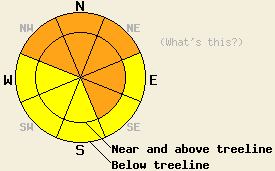
Avalanche danger is CONSIDERABLE today in wind loaded areas near and above treeline on NW-N-NE-E-SE aspects, 34 degrees and steeper. Near treeline and below treeline, avalanche danger is CONSIDERABLE on NW-N-NE aspects near and above 7,000' on slopes 32 degrees and steeper due to possible overloading of persistent weak layers near the base of the snowpack. In other areas, avalanche danger is MODERATE. |
|
|
|
A significant storm system continues to impact the forecast area this morning. Snowfall intensity peaked yesterday evening, but moderate snowfall is expected to continue along the Sierra Crest through this morning. Storm totals at the 8,000' level are running 20 to 47 inches with an additional 6 to 12 inches expected today. Ridgetop winds remain out of the southwest and have decreased this morning to moderate in speed. Winds peaked yesterday afternoon with hourly averages of 80 mph and gusts over 100 mph. Air temperatures decreased to the low to mid twenty's overnight for most locations and are expected to remain in the twenty's today.
Observations made yesterday on Pickett Peak (Carson Pass area), Silver Peak (Pole Creek area), and in Negro Canyon (Donner Summit area) all revealed widespread whumpfing triggered by individuals traveling on skis. These areas of unstable slabs were noted to collapse but still maintain enough strength not to fully detach and slide downhill. Stability tests and fracture propagation tests revealed that failure within the new snow occurred more easily than failure on known weak layers deep in the snowpack (video). No natural avalanche activity was observed in any of these areas. An additional 12 to 16 inches of new snow accumulated from late yesterday afternoon through the overnight hours in most areas, which is less than what was expected. An outlying 22 inches was reported overnight from a snow study plot at 7,800' on Donner Summit.
Squaw Valley Professional Ski Patrol reported that avalanche control work with explosives yesterday morning created widespread avalanche activity within the new snow. Several avalanches involving the storm snow were triggered last night by a grooming machine, but the failure layer and bed surface that exists within the ski area may or may not exist within the backcountry due to previous grooming and explosive control work.
Avalanche concern #1:
Wind loading and unstable slab formation will continue to exist today. Above treeline and near treeline areas on NW-N-NE-E aspects will receive the greatest amounts of wind loading. Snowpack failure may occur either within the storm snow or at ground level. Natural avalanches remain possible in these areas today. Human triggered avalanches are likely. Large destructive avalanches are possible.
Avalanche concern #2:
Deep slab instability remains possible in below treeline areas as the October 19 facet layer and possibly the November 22 thin rain crust/facet layer have become heavily loaded by significant accumulation of higher density new snow during the past 2 days. A variety of weak layers are known to exist near treeline and below treeline in the lower and middle portions of the snowpack near and above 7,000' on NE wind protected NW-N-NE aspects throughout the forecast area. These weak layers vary by location and individual slopes, taking the form of either basal facets (Sierra Crest and Carson Range), facets on top of the early October basal ice mass (Sierra Crest and Carson Range above 8,600'), and as small faceted crystals on top of the thin Nov 22 rain crust (Sierra Crest up to 9,000'). Stability tests and fracture propagation tests performed over the past several days indicate that significant avalanche activity is possible below treeline once these weak layers become overloaded and snowpack failure occurs. This is a situation that is unusual for this region. Backcountry travelers cannot afford to be lulled into a sense of security below treeline in areas where these weak layers exist. Large destructive avalanches below treeline are possible.
Avalanche danger is CONSIDERABLE today in wind loaded areas near and above treeline on NW-N-NE-E-SE aspects, 34 degrees and steeper. Near treeline and below treeline, avalanche danger is CONSIDERABLE on NW-N-NE aspects near and above 7,000' on slopes 32 degrees and steeper due to possible overloading of persistent weak layers near the base of the snowpack. In other areas, avalanche danger is MODERATE.
| 0600 temperature: | 21 to 24 deg. F. |
| Max. temperature in the last 24 hours: | 28 to 30 deg. F. |
| Average wind direction during the last 24 hours: | Southwest |
| Average wind speed during the last 24 hours: | 45 mph |
| Maximum wind gust in the last 24 hours: | 103 mph |
| New snowfall in the last 24 hours: | 12 to 22 inches |
| Total snow depth: | 40 to 65 inches |
For 7000-8000 ft: |
|||
| Sunday: | Sunday Night: | Monday: | |
| Weather: | Cloudy skies with snow in the morning. Numerous snow showers in the afternoon. | Cloudy skies with scattered snow showers in the evening. Isolated snow showers after midnight. | Mostly cloudy skies. |
| Temperatures: | 25 to 32 deg. F. | 15 to 22 deg. F. | 28 to 35 deg. F. |
| Wind direction: | SW | SW | SW |
| Wind speed: | 15 to 25 mph with gusts to 55 mph. Gusts decreasing to 45 mph in the afternoon. | 10 to 15 mph with gusts to 30 mph in the evening. | Around 10 mph. |
| Expected snowfall: | 4 to 8 in. | 0 to 1 in. | O in. |
For 8000-9000 ft: |
|||
| Sunday: | Sunday Night: | Monday: | |
| Weather: | Cloudy skies with snow in the morning. Numerous snow showers in the afternoon. | Cloudy skies with scattered snow showers. | Mostly cloudy skies. |
| Temperatures: | 20 to 27 deg. F. | 11 to 18 deg. F. | 26 to 33 deg. F. |
| Wind direction: | SW | SW | W |
| Wind speed: | 25 to 40 mph with gusts to 65 mph. Gusts decreasing to 55 mph in the afternoon. | 20 to 30 mph with gusts to 40 mph. Winds decreasing to 15 to 20 mph with gusts to 35 mph after midnight. | 10 to 20 mph with gusts to 30 mph. Gusts increasing to 40 mph in the afternoon. |
| Expected snowfall: | 6 to 12 in. | 0 to 1 in. | O in. |


This website is owned and maintained by the non-profit arm of the Sierra Avalanche Center. Some of the content is updated by the USDA avalanche forecasters including the forecasts and some observational data. The USDA is not responsible for any advertising, fund-raising events/information, or sponsorship information, or other content not related to the forecasts and the data pertaining to the forecasts.

