In partnership with: 
|
December 18, 2009 at 7:40 am |
|
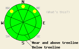
Near treeline and below treeline, pockets of MODERATE avalanche danger exist above 8,000' on NW-N-NE aspects, 35 degrees and steeper due to persistent deep slab instability. Above treeline and for all other areas, avalanche danger is LOW. |
|
|
|
High pressure is in place over the forecast area this morning. An air temperature inversion is in place with most remote sensors above 8,000' reporting air temperatures above freezing. Ridgetop winds became light yesterday. Winds have shifted from west to north overnight and are expected to remain light today.
Yesterday, observations made below treeline on Pickett Peak in the Luther Pass area at 8,300' on a NW aspect 33 degree slope continue to point to persistent instability of the Oct 19 facet layer near the bottom of the snowpack. Fracture propagation tests indicated that failure and fracture propagation along this layer remains likely once triggered (video). This matches well with observations made Wednesday in similar terrain at higher elevations on Tamarack Peak in the Mount Rose area (pit profiles). Observations made yesterday below treeline on Silver Peak in the Pole Creek area at 8,020' on a NE aspect, 30 degree slope indicated that in areas where the Oct 19 facet layer was less developed, the snowpack was now stable despite evidence of instability prior to the Dec 12 - Dec 13 storm cycle (video).
Today's avalanche concerns continue to focus on persistent deep slab instability below treeline. Areas above 8,000' on NW-N-NE aspects that are somewhat protected from NE winds hold the Oct 19 facet layer near or at the bottom of the snowpack. In some locations, these faceted crystals have rounded and bonded with the slab above stabilizing the snowpack. There are two snowpack structures that are worrisome at this time. The first exists between 8,000' to 8,600' where the faceted weak layer at ground level is very well developed (soft and sugary). The second exists above 8,600' where the facet layer sits on top of the ice mass that formed in early Oct. Both of these configurations continue to show evidence of instability. Human triggered failure of this weak layer is becoming increasing difficult. However, the right trigger placed in a shallow portion of the snowpack, near an isolated rock, or isolated tree can still cause an avalanche with the dense overlying slab 2 to 4+ feet in thickness. An avalanche of this type holds significant destructive potential and severe consequences for anyone caught in the avalanche. Dig your pits and choose your slopes wisely as this layer is very weak in some locations and nonexistent in others.
Near treeline and below treeline, pockets of MODERATE avalanche danger exist above 8,000' on NW-N-NE aspects, 35 degrees and steeper due to persistent deep slab instability. Above treeline and for all other areas, avalanche danger is LOW.
| 0600 temperature: | 34 to 36 deg. F. |
| Max. temperature in the last 24 hours: | 36 to 48 deg. F. |
| Average wind direction during the last 24 hours: | West |
| Average wind speed during the last 24 hours: | 15 mph |
| Maximum wind gust in the last 24 hours: | 26 mph |
| New snowfall in the last 24 hours: | O inches |
| Total snow depth: | 37 to 54 inches |
For 7000-8000 ft: |
|||
| Friday: | Friday Night: | Saturday: | |
| Weather: | Mostly cloudy skies in the morning, becoming partly cloudy. | Partly cloudy skies in the evening, becoming mostly cloudy. | Mostly cloudy skies. |
| Temperatures: | 37 to 44 deg. F. | 27 to 33 deg. F. | 38 to 45 deg. F. |
| Wind direction: | N | W | NW |
| Wind speed: | Light winds | Light winds | Light winds |
| Expected snowfall: | O in. | O in. | O in. |
For 8000-9000 ft: |
|||
| Friday: | Friday Night: | Saturday: | |
| Weather: | Mostly cloudy skies in the morning, becoming partly cloudy. | Partly cloudy skies in the evening, becoming mostly cloudy. | Mostly cloudy skies. |
| Temperatures: | 37 to 44 deg. F. | 24 to 31 deg. F. | 38 to 45 deg. F. |
| Wind direction: | N | W | NW |
| Wind speed: | Up to 10 mph. | Up to 10 mph. | Up to 10 mph. |
| Expected snowfall: | O in. | O in. | O in. |


This website is owned and maintained by the non-profit arm of the Sierra Avalanche Center. Some of the content is updated by the USDA avalanche forecasters including the forecasts and some observational data. The USDA is not responsible for any advertising, fund-raising events/information, or sponsorship information, or other content not related to the forecasts and the data pertaining to the forecasts.

