In partnership with: 
|
December 20, 2009 at 8:01 am |
|
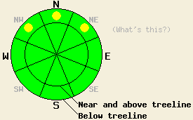
Near treeline and below treeline, pockets of MODERATE avalanche danger exist above 8,000' on NW-N-NE aspects, 35 degrees and steeper due to persistent deep slab instability. For all other areas, avalanche danger is LOW. |
|
|
|
The southwest winds and cloud cover have started to increase ahead of a series of low pressure systems. The first and weaker of these systems should reach the forecast area this afternoon with cooler temperatures and a chance of snow showers through tonight. The forecast calls for the second stronger, wetter system to impact the forecast area starting Monday afternoon and continuing through Tuesday. This system should bring more significant snow accumulation, colder temperatures, and stronger southwest winds.
Snowpits show that the Oct. 19th facet layer still exists near the base of the snowpack on NW-N-NE aspects above 8000'. In some areas like on Rubicon Peak yesterday and Silver Peak late last week, this layer has gained some strength. Tests in these areas indicate a more stable snowpack. In other areas like Incline Lake Peak, Mt. Lola, Castle Peak, and Picket Peak where more well developed facets (larger, more sugary snow grains) exist, snowpit tests performed over the last 4 days still indicate that this layer remains weak. These tests show that if this layer starts to break the fracture can propagate across a large area through these facets. Snowpit observations show that the snow from most recent storms has consolidated into 3-4 feet of cohesive snow. Where it sits on top of the facet layer, this 3-4 feet of snow represents a thick slab layer.
Primary avalanche concern:
Large destructive avalanches remain possible on NW-N-NE slopes above 8000' where the Oct. 19th facet layer exists. Even though the thick, well-consolidated snow above this layer makes it harder to break these facets, the right trigger in the right place could still initiate a fracture in this layer. Once that happens the fracture can propagate through this layer making the 3-4 feet of well consolidated snow a dense, destructive, 3-4-foot-deep slab. Areas near exposed rocks, trees, or on the edges of the slab where a shallower snowpack exists will represent the most likely places where people could trigger an avalanche due to failure of this layer.
Near treeline and below treeline, pockets of MODERATE avalanche danger exist above 8,000' on NW-N-NE aspects, 35 degrees and steeper due to persistent deep slab instability. For all other areas, avalanche danger is LOW.
| 0600 temperature: | 34 deg. F. |
| Max. temperature in the last 24 hours: | 44 deg. F. |
| Average wind direction during the last 24 hours: | Southwest |
| Average wind speed during the last 24 hours: | 20 mph |
| Maximum wind gust in the last 24 hours: | 42 mph |
| New snowfall in the last 24 hours: | O inches |
| Total snow depth: | 35-52 inches |
For 7000-8000 ft: |
|||
| Sunday: | Sunday Night: | Monday: | |
| Weather: | Cloudy with isolated snow showers in the afternoon. | Mostly cloudy with isolated snow showers | Cloudy with a chance of snow. |
| Temperatures: | 38-45 deg. F. | 23-30 deg. F. | 33-40 deg. F. |
| Wind direction: | Southwest | Southwest | Southwest |
| Wind speed: | 10-15 mph with gusts to 35 mph | 15-25 mph with gusts to 40 mph | 15-25 mph with gusts to 40 mph |
| Expected snowfall: | trace in. | trace in. | up to 2 in. |
For 8000-9000 ft: |
|||
| Sunday: | Sunday Night: | Monday: | |
| Weather: | Cloudy with isolated snow showers in the afternoon | Mostly cloudy with isolated snow showers | Cloudy with a chance of snow |
| Temperatures: | 37-44 deg. F. | 20-27 deg. F. | 32-38 deg. F. |
| Wind direction: | Southwest | Southwest | Southwest |
| Wind speed: | 20-30 mph with gusts to 60 mph | 25-40 mph with gusts to 65 mph | 30-45 mph with gusts to 70 mph |
| Expected snowfall: | trace in. | trace in. | up to 2 in. |


This website is owned and maintained by the non-profit arm of the Sierra Avalanche Center. Some of the content is updated by the USDA avalanche forecasters including the forecasts and some observational data. The USDA is not responsible for any advertising, fund-raising events/information, or sponsorship information, or other content not related to the forecasts and the data pertaining to the forecasts.

