In partnership with: 
|
December 27, 2009 at 7:59 am |
|
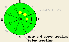
This morning LOW avalanche danger exists at all elevations and on all aspects. This afternoon pockets of MODERATE danger may develop above treeline on the most heavily wind-loaded N-NE-E aspects steeper than 35 degrees. Isolated, deep-slab instability remains unlikely but not impossible near and below treeline on NW-N-NE aspects above 8,000 ft. If more snow falls than forecasted, the avalanche danger will become more widespread. |
|
|
|
Most remote sensors only reported a trace amount of new snow overnight. The small low pressure system passing through the forecast area today could bring as much as 6 more inches of snow to the Sierra above 7000'. The winds should remain moderate out of the southwest. Temperatures should remain cool with daytime highs for today and tomorrow only reaching the high teens and low twenties. By tomorrow the winds should decrease and shift towards the southeast as this system moves out of the area.
Observations from Waterhouse Peak near Luther Pass yesterday showed a layer of weak, sugary crystals near the bottom of the snowpack (the Oct. 19th facet layer- photo). Snowpit tests on this layer at Waterhouse Peak (video), in the Deep Creek area (video), and on Carpenter Ridge (video) this week indicated that if this layer breaks, the fracture can propagate through the snowpack along these weak facets. In other areas including Incline Lake Peak, Cold Stream Canyon, Silver Peak, and Mt. Tallac, tests showed a strengthening trend in this layer. All of the recent observations indicate that the strength and distribution of this layer remains variable. Observations also showed that the strong, well-consolidated snow above the facets makes failure of this layer due to human-triggering unlikely. Observations from Waterhouse Peak and from Mt. Tallac yesterday on sheltered N-NE facing slopes showed that 4-6 inches of soft, unconsolidated snow existed on the surface in these areas. On exposed aspects, a mix of wind-scoured surfaces and wind-packed hard slabs existed.
Avalanche concern #1:
New wind slabs will start to form on exposed N-NE-E aspects near and above treeline today due to wind-loading from the southwest winds. If snowfall amounts stay on the mid to low end of the forecast (2-4 inches), these slabs should remain small and shallow (6-12 inches deep) only posing a threat to backcountry travelers on the most heavily wind-loaded slopes. However, if snowfall amounts start to reach into the highest end of the forecasted range (6 inches), 1-2 ft deep wind slabs could form on wind-loaded aspects. These larger wind slabs would also be more widespread and more sensitive to human triggering.
Avalanche concern #2:
Human-triggered avalanches resulting from failure of the Oct 19th facet layer remain unlikely but not impossible. Small, isolated areas where the weight of a person could break this layer may still exist on sheltered, NW-N-NE aspects above 8000 ft. In the unlikely event that avalanche activity does occur due to failure of this layer, the resulting avalanches will release without warning with crowns of 2-4 ft deep. These large avalanches would have dire consequences for those who triggered them. The uncertainty surrounding this layer's strength and distribution make stability evaluations on slopes with this layer unreliable and difficult. For these reasons continued caution in the backcountry is advised.
This morning LOW avalanche danger exists at all elevations and on all aspects. This afternoon pockets of MODERATE danger may develop above treeline on the most heavily wind-loaded N-NE-E aspects steeper than 35 degrees. Isolated, deep-slab instability remains unlikely but not impossible near and below treeline on NW-N-NE aspects above 8,000 ft. If more snow falls than forecasted, the avalanche danger will become more widespread.
| 0600 temperature: | 21 deg. F. |
| Max. temperature in the last 24 hours: | 29 deg. F. |
| Average wind direction during the last 24 hours: | Southwest |
| Average wind speed during the last 24 hours: | 20 mph |
| Maximum wind gust in the last 24 hours: | 42 mph |
| New snowfall in the last 24 hours: | trace to 1 inches |
| Total snow depth: | 33-54 inches |
For 7000-8000 ft: |
|||
| Sunday: | Sunday Night: | Monday: | |
| Weather: | Snow | Cloudy with a slight chance of snow showers | Cloudy with a slight chance of snow showers |
| Temperatures: | 23-28 deg. F. | 11-18 deg. F. | 22-29 deg. F. |
| Wind direction: | Southwest | Southeast | Southeast |
| Wind speed: | 10 mph | up to 10 mph | 10 mph becoming light in the afternoon |
| Expected snowfall: | 2-4 in. | O in. | O in. |
For 8000-9000 ft: |
|||
| Sunday: | Sunday Night: | Monday: | |
| Weather: | Snow | Cloudy with a slight chance of snow showers | Cloudy with a slight chance of snow showers |
| Temperatures: | 18-23 deg. F. | 10-17 deg. F. | 18-23 deg. F. |
| Wind direction: | Southwest | Southeast | Variable |
| Wind speed: | 15-25 mph with gusts to 35 mph | 10 mph | 10 mph becoming light in the afternoon |
| Expected snowfall: | 2-4 in. | O in. | O in. |


This website is owned and maintained by the non-profit arm of the Sierra Avalanche Center. Some of the content is updated by the USDA avalanche forecasters including the forecasts and some observational data. The USDA is not responsible for any advertising, fund-raising events/information, or sponsorship information, or other content not related to the forecasts and the data pertaining to the forecasts.

